Elevation: 10,718 ft
Prominence: 378
This peak is not in the book.
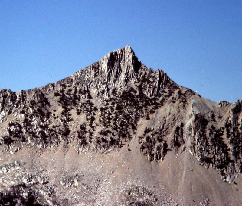
Peak 10718 is an impressive peak that is located 0.7 miles west of Peak 11202 and 0.7 miles south of Island Lake. It is seldom climbed. Livingston Douglas has provided the detailed route information set out below as well as suggesting the name Hourglass Peak since it overlooks Hourglass Lake to it south. Also see Dave Pahlas’ trip report linked below. USGS Boulder Chain Lakes
It will be a steep climb up Peak 10178, no matter what side you decided to try.
Southeast Ridge, Class 3 by Livingston Douglas
Access
[(B)(2)(a.1) FST-680 and FST-601, Big Boulder Creek Trail on Page 230]
The Climb
From the Big Boulder Creek trailhead parking lot, hike up FST-047, passing the Livingston Mill cabins/buildings on your right. Continue on FST-047 until reaching a trail junction at the Wilderness Boundary, which is about 2-1/2 miles from the trailhead parking lot. At this junction, FST-047 goes left; FST-680 (Big Boulder Creek Trail) goes straight. Go straight on FST-680 here. Just over 1-1/2 miles later, reach another trail junction; continue straight ahead on FST-680. Just under 1/2 mile from the trail junction, cross Gunsight Creek on a log bridge. Continue up the trail another 1-1/4 miles to a footbridge across the Walker Lake outlet stream (8,850 feet).
Please note that the Boulder Chain Lakes map inaccurately places this stream crossing at 8,700 feet. This is an important error because it will confuse you as to where you should leave the trail to begin the bushwhack up to Goat Lake. Go straight at the trail junction for FST-601/Walker Lake (the trail sign says “Walter Lake”) to continue up towards Island Lake. The Walker Lake Trail is NOT SHOWN on the USGS quadrangle. About 1/4 mile after crossing the Walker Lake outlet stream, reach two stream crossings with small footbridges across them. These two streams are branches of the Island Lake outlet stream. Warning: the USGS map does NOT SHOW the trail crossing the outlet stream coming down from Island Lake until much higher in elevation; the map is wrong. After the second crossing, leave the trail to bushwhack east below imposing cliffs to reach the outlet stream coming down from Goat Lake.
Bushwhack through massive boulders and thick forest on the south side of the Island Lake outlet stream, at the base of massive cliffs on your right side, to reach Goat Lake’s outlet stream. Unfortunately, you must drop 150 vertical feet to get underneath the right-side cliff face and reach the critical outlet stream coming down from Goat Lake. This is not a pleasant traverse/bushwhack but, thankfully, it only takes about 10 minutes to complete. When you return from Goat Lake, you can avoid most of the uphill by traversing across the braided branches of the Island Lake outlet stream and intercepting the trail just below a waterfall (rather than retracing your ascent route). The forest is relatively flat and unpleasant with deadfall, but it goes pretty quickly (I only ascended 30′ to get back to the trail).
To reach Goat Lake, first climb on the left/east side of the outlet stream then, when cliffs force you to do so, cross the stream and finish the climb on the R/W side of the stream. Goat Lake is beautiful. It is well worth the pain you’ve gone through to get here. Cross the outlet stream and skirt the E side of Goat Lake with some help from an on-and-off game trail. Once past Goat Lake, scramble up the climber’s left/E side of the inlet stream. You will reach a flat tundra basin at 9,200 feet, just E of an unnamed lake. Continue southward, leaving the gentle tundra and climbing endless boulders (glacial moraine) to finally reach the upper basin at 9,650 feet. Directly to the S is an imposing prow of cliffs. This prow splits the basin. It’s decision time now. If you plan to climb Peak 10718, you will scramble SSW up to an obvious ridge saddle. If you choose to climb Peak 11202, you will scramble SSE up to a flat area on the ridge that lies just E of the imposing prow.
To climb the southeast ridge of Peak 10718, scramble up the loose scree in the cirque. Use rock ribs on the east side of the cirque as necessary to make progress in the steeper sections. You want to reach the ridge just above, and west of, the ridge saddle. It is too steep to climb directly to the ridge saddle itself because a sheer headwall blocks your way at the top of the cirque. So as you get closer to the ridge, angle your way rightward/westward to access the ridge. Once on the ridge, you will feel great relief. After all, you’ve spent the past hour or so fighting with boulders and dreadfully loose scree to climb from the tundra basin to the ridge. You are rewarded with an outstanding view of many of the Boulder Chain of Lakes located to the immediate south of your perch.
Your joy will quickly turn to sadness when you see what the Southeast Ridge of Peak 10718 looks like. Tom Lopez calls this a “rough peak that is seldom climbed” and now you can see why. But there is good news. The southeast ridge is actually a relatively pleasant Class 3 endeavor. The ridge proper is littered with many ugly cliff bands and towers so you’ll have to avoid the ridge crest itself. And, from here, the summit block/fin appears to be a Class 5 finish. Wrong again. It won’t be and you WILL stand on top of this bad boy. Climb the southeast ridge, staying to the right/north of ridge problems. Amazingly, you’ll reach the summit boulders with an easy Class 3 scramble. The highest summit boulder goes at Class 2+, not Class 5. The views from the summit are stunning. Very few climbers have enjoyed this special viewpoint. Tom Lopez got that right.
If you plan to also climb Peak 11202 today, by doing a ridge traverse over to that peak (which the USGS map shows as feasible), I have some bad news for you. The map conveniently hides an imposing tower/block just east of the ridge saddle at 10,400 feet. I couldn’t see a way over or around it and I had planned to climb Peak 11202 today. There is a way to do it the same day, however. Return to the ridge saddle area where you reached the ridge. From there, descend 600 vertical feet down to just below 9,800 feet and contour eastward on dreadful glacial moraine boulders to reach the east side cirque mentioned earlier. From there, please consult the southwest ridge/southwest face route for Peak 11202 for more details.
If Peak 10718 is your sole objective for the day, simply retrace your steps back down past Goat Lake and down to the base of the outlet streaming coming from the lake. Bushwhack the revised route mentioned earlier to intercept FST-680 (Big Boulder Creek Trail) and follow the trail back down to the large trailhead parking lot.
Additional Resources
Regions: EASTERN IDAHO->White Cloud Mountains
Mountain Range: White Cloud Mountains