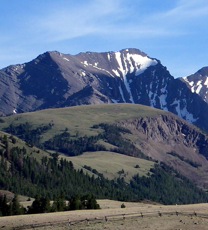
While a climber can choose to climb any mountain for any reason, we all tend to be interested in their stats to some degree. Idaho’s budding peakbaggers are generally only after the handful of summits over 12,000 feet in elevation with 300 feet of prominence (the widely used cutoff for what constitutes a separate mountain). Those who get hooked might broaden their scope to the peaks above 11,000 feet. And the most devoted collect ascents of any point with 300 feet of prominence; spending their off-season hiking up 5,000-foot sagebrush-covered hills in the southern portion of the state.
The inconvenient truth is that this game has been hinged upon the numbers and lines that appear on old, hand-drawn topographic maps created by surveyors in the field using only simple tools and trigonometry. Via triangulation, they must draw in every contour line and mark every elevation value based on the height relative to sea level. It’s an impressive feat, no doubt, but it’s destined to produce inaccuracies and errors.
The other problem we’ve faced is using interpolated values. While most summits are marked with a spot elevation (an exact, whole number value) for the highest point, the saddles used to calculate prominence—and even many summits—are represented only by contour lines drawn every 40 feet. The best we’ve been able to do is take an average between the last contour line drawn on the map and the next line that feature could have barely fallen short of. This means when you see a peak listed with a prominence of 305 feet, what it’s actually saying is ‘the map shows the prominence could be anywhere between 285 feet (clean prominence) and 325 feet (optimistic prominence) so we’re going with the value right in the middle‘.
For any summit that does not have a spot elevation (such as Mount Church), our range of possible prominence values doubles to 80 feet. If you’re inquisitive as I am, as soon as you learn about that you start wondering, “When will we know for certain if the borderline peaks are ranked or not?”; “When we will know which is the highest of competing summits?”; “When will we discover the true stats of these mountains??”
That time has finally arrived, thanks to USGS’s recent push to get the entire country measured with LiDAR (an acronym of ‘light detection and ranging’). Basically this means low-flying aircraft are scanning the earth’s surface using lasers. If you’d like to know more, you can continue reading here: https://www.usgs.gov/faqs/what-lidar-data-and-where-can-i-download-it.
LiDAR technology has been around for decades, but was previously only used for small-scale projects. According to USGS, LiDAR elevation data are accurate to within four inches—an adequate level of precision for us to solve our mountain mysteries once and for all. Eventually, USGS will be able to use these data to create the next generation of topo maps. It seems likely that they’re going to wait and roll out one big update when they’re ready.
You can view the progress of data collection here: https://apps.nationalmap.gov/lidar-explorer/#/. The mountains of the west are mostly all that remains and those data have started to trickle in. Fortunately, we don’t have to wait for USGS to use these data for their own map and peak profile updates. With a bit of know-how, you can download the data and dive in to answer those burning questions about our mountains.
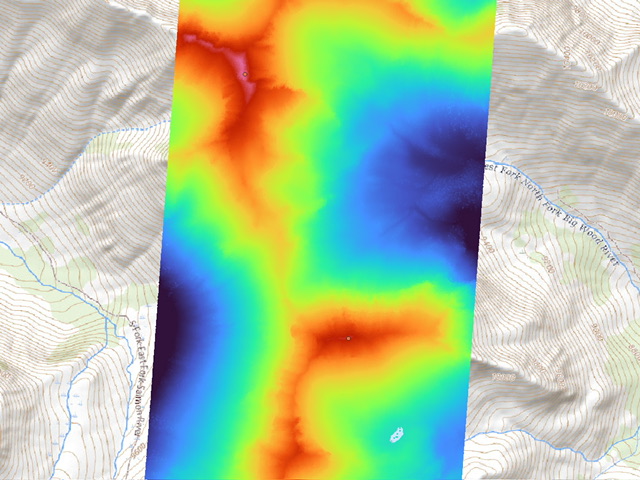
Here’s where the analysis begins. I’ve downloaded two tiles of LiDAR data that include Down East Peak and Window Peak and imported them into QGIS. A rainbow color ramp has been set for an elevation range of 9,500 feet-11,200 feet.
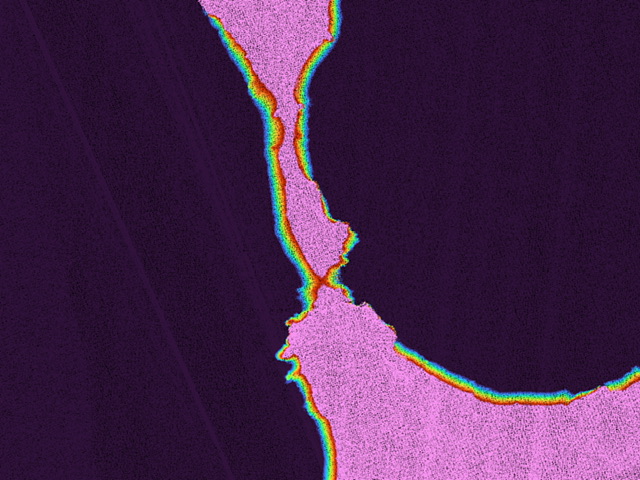
After finding the highest point on Window Peak, I move to the saddle between the two peaks to locate the key col needed to calculate its prominence. I’ve narrowed down the rainbow color ramp to 10,465 feet-10,480 feet (below that is black and above that is pink). Now I can clearly see that little red bottleneck is the lowest part of the saddle. I will continue to zoom in and reduce the elevation range in the color ramp until I can pick out the highest point of the lowest passing.
[These images are cropped down to the map portion of the QGIS program. The software is complex and showing a convoluted image of the entire interface would be difficult. Also as you keep zooming in you eventually get to individual data points.]
The first place you’re going to encounter these peak updates will be the ‘Lists of John’ website. To create this database initially, the admin spent thousands of hours poring over topo maps of entire the country to find every last peak with 300 feet of prominence. To the most dedicated peakbaggers who are interested in exploring beyond the popular mountains, every other similar website is simply a novelty. With the help of others, admin John Kirk is now taking on the next massive undertaking of updating 200,000 mountains with their LiDAR stats—in addition to investigating new, potentially ranked peaks that hat were previously overlooked due to map errors. With practice, each peak’s summit and saddle elevations can be found in about 5 minutes so the database overhaul will take years to complete.
In Spring 2023, the first batch of LiDAR data to include some of Idaho’s high peaks was released and, since then, two more batches have come in. While I haven’t formally submitted my findings to ‘Lists of John’ (I plan to do that soon), I’ve personally been tearing into those data like a kid opening Christmas presents. Nearly half of Idaho’s 10ers and 11ers now have LiDAR elevation data available. My focus has mainly been on peaks that have potential for a ranked/unranked status change. Here are some highlights:
–Heyburn’s east summit clocked in just 5” lower than the west summit
-Heyburn’s west pinnacle has 293 feet of prominence. Just seven more feet and it would have been the most challenging 10er in Idaho
-Peak 11909 might need a new name, since its elevation is 11917 feet (but I’m happy to continue calling it Peak 11909)
-Jerry Peak (10,013 feet) is indeed taller than South Jerry Peak (10,009 feet)
-Peak 9940, a formerly soft-ranked peak just east of Braxon, is not only ranked but it’s also a 10er! The map is missing two contour lines on the 10,014-foot summit.
-Senate Peak loses its 10er status with just 294 feet of prominence
-Judas Peak, just southeast of Hope Peak, is not much of a peak at all with only 219 feet of prominence. Our previous estimate was off by 101’ feet due to erroneous contour lines drawn in the saddle. Sad news for the climber who claimed the first ascent (the author). I should have anticipated such a betrayal from “Judas.”
So where do we go from here? Other parts of the country have organizations that oversee peak lists and certify their completers. A committee will vote on changes to the lists, and more often than not, they choose to preserve the traditional list despite its proven inaccuracies. The Appalachian Mountain Club has updated the White Mountain 4,000-footers (easily the most popular peakbagging list in the USA) in their latest guidebook with LiDAR elevations, but have no intention of dropping Mt. Tecumseh even though the new elevation is 3,995 feet. It was also discovered that Mt. Guyot should technically be added and South Hancock should be dropped and due to their updated prominence measurements—but again dogma will prevail over facts in this case.
Idaho’s peakbagging lists are all simply generated by objective criteria so new measurements can create updates and corrections to the lists. The 2,000-foot prominence list has several peaks riding either side of the cutoff line. The county highpoints list can now be cleaned up, as many of the counties have two or three high point candidates that highpointers have had to visit to ensure they attained the correct one. The ranked 12ers are unlikely to see any changes, but when we get down to the 11ers list that we’ve worked from for the past 18 years, it’s going to be a different story.
There are some potential elevation shifts that could change the 11ers list, such as Italian Peak gaining four feet or The Brow losing six feet, but most of our changes will likely be related to prominence. North Cabin and Little Regret are barely hanging on—with a few others not looking much safer. ‘Lists of John’ includes three “soft-ranked” 11ers (all in the Pioneers) that each have 280 feet of prominence which means 300 feet of optimistic prominence. In theory, if you climbed all the soft-ranked peaks from your desired list you’d have all your bases covered—however that’s based on the assumption that the topo maps are error-free.
LiDAR has already shown us that is definitely not the case. In fact, I have been inspired to write this article because I used the latest batch of LiDAR data to discover a previously unknown 11er in the Boulder Mountains. The map shows Point 11175 to have 275 feet of prominence so it wasn’t on anyone’s radar. We’re still waiting on LiDAR for most of the Lost River Range (coming soon) and all of the Pioneer Mountains (still haven’t been scanned so it could be a few years). I predict we’ll see a few more changes to the 11er list once all the results are in.
What does that mean for our list completers? Here I will offer my best read on peakbagger etiquette. The finishers all completed the known list at the time, and their legacy forever remains intact. For example, William Ervin and Carl Blaurock are credited with being the first completers of the Colorado 14ers—even though their list in 1923 was twelve peaks shorter than the current list. It is certainly good form for prior completers to climb any new peaks, provided they are still alive and able-bodied. For everyone else who is working on a list that they intend to finish, your target will likely shift on you a bit as we enter this new era.
While some of Idaho’s peak lovers may be less excited to see changes happening, we can all take solace in the fact that this is it. The new elevations are so accurate that we won’t have to worry about list changes again. The only potential exceptions that come to mind:
–Peaks with a LiDAR prominence of 299 feet or 300 feet could make a critical jump of a few inches when measured again in the future
-Earthquakes certainly have the power to knock summit blocks free and otherwise modify the landscape
-A recalculation of sea level could shift summit elevations slightly (but not prominence values)

How much detail are we talking about? This image shows the base of a mountain in that is covered with trees and bushes.
If you haven’t already noticed, I love talking about mountains! Feel free to email questions related to this article to derek@perco.ski
-Derek Percoski