Elevation: 9,140 ft
Prominence: 360
This formation is not in the book specifically but is discussed as part of the Cathedral’s Cemetery climbing area. Dana Hanson and I climbed this peak in 1984 following the lead of Paul Bellamy. I am not sure if it was a first ascent. We did not see evidence of other climbers, but I know this area was worked over by members of the Idaho Falls Alpine Club. Published November 2023
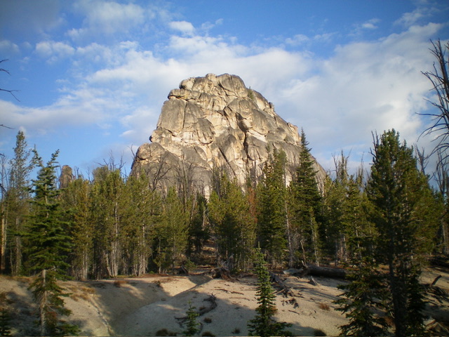
Peak 9140 South is a handsome block of rock that is just off FST-021 in the Bighorn Crags. Tom Lopez has the only recorded climb of this Class 5 crag. Don’t confuse it with Peak 9140 North, another Tom Lopez achievement nearby just to the north. USGS Hoodoo Meadows
Peak 9140 South as viewed from the east. Livingston Douglas Photo
Access
From the 4-way road junction, drive north then west then south up FSR-113 for a rugged, rutted 8.3 miles to a signed junction with FSR-114/Yellowjacket Lake Road. Turn right/northwest to stay on FSR-113/Bighorn Crags Road and drive 2.2 miles to the “Hiker’s Trailhead” at Bighorn Crags. The trailhead is just past the turnoff for Bighorn Crags Campground. It is at 8,475 feet and 45⁰06’15”N, 114⁰31’27”W.
Map Errors
The stock trail (FST-236) is shown on the USGS topo map. However, the hiker’s trail (FST-021) is not shown on the map.
The Approach
From the trailhead, hike up steep, rocky FST-021 to where it skirts the east side of Peak 9046 then bends left/west to cross its north ridge in open terrain. Continue northwest then north on the trail as it descends about 275 feet to a saddle and a signed trail junction. The stock trail (FST-236) reaches the ridge trail at this junction.
Continue north on FST-021 to reach the east side of Peak 9140 South in a semi-open pine forest. Bushwhack west around the south end of the imposing summit block and work around to the back side of the behemoth. At the north end of the west side of the massive block is the block’s weakness: a chute that leads up to the steep granite blocks/boulders above. From the top of that chute, it is a Class 5 climb to reach the top of the massive summit block.
Additional Resources
Mountain Range: Eastern Salmon River Mountains
Year Climbed: 1984
Longitude: -114.5458 Latitude: 45.1180