Elevation: 5,356 ft
Prominence: 40
This peak is not in the book.
This information is from the Panhandle National Forest web site.
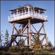
Arid Peak Lookout is set on a 20 foot tower and overlooks the beautiful Loop Creek area and the scenic “Route of the Hiawatha rail-trail”. It is on the National Historic Register of Fire Lookouts.
Getting to the lookout requires a moderate 3 mile hike. See the directions below. Arid Peak Lookout was built in 1934 to provide early detection of fires potentially sparked by the Milwaukee Railroad line. It was last staffed in 1969 and sat idle for over 25 years. Arid Peak Lookout was restored to it’s original splendor in 1996 and 1997.
Access and Route, Class 1
From the town of Avery turn left and head north up the North Fork of the St. Joe River Road FS-456 toward Wallace. Travel approximately 4.5 miles; then turn left down the hill just before the bridge across the river. You will then be on Road No. 1997 which is a single lane gravel road with pull outs. Travel approximately 3.5 miles and turn left on the first road (also labeled FST-1997). Travel approximately 6.5 miles to Trailhead for FST-175. There is a turn-around just past the trailhead before the gate. Do not block the turnaround or the gate. You can park in the wide spot by the trailhead. Hike up FST-175 approximately 1.5 miles to its junction with FST-173. Turn right and hike approximately 1.5 miles to Arid Peak.
Additional Resources
Regions: NORTHERN IDAHO
Mountain Range: Saint Joe Mountains
Longitude: -115.767542 Latitude: 47.367468