Elevation: 9,248 ft
Prominence: 668
This peak is not in the book. Published November 2018
Bald Mountain is the largest of the scrub-covered peaks and points on the ridge crest that extends from Rowley Canyon south to Montpelier Canyon. When viewed from US-30, Bald Mountain is a BIG mountain. It is not the highest peak on this ridge (Peak 9420 is over 150 feet higher), but it is the most impressive one. USGS Georgetown
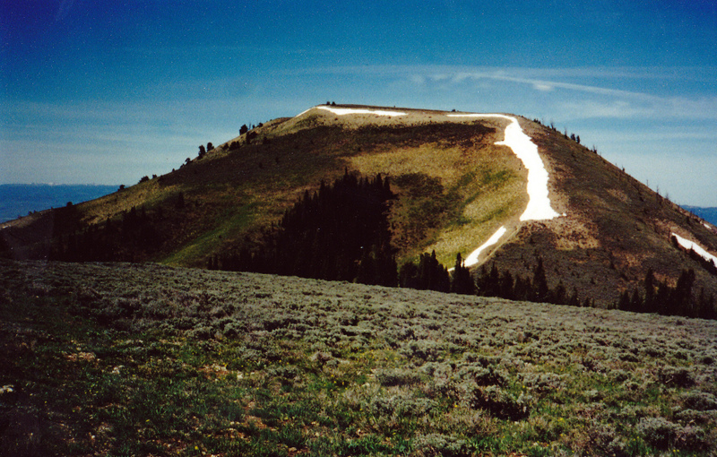
Yet another Idaho peak named Bald Mountain! This one is located in the Pruess Range northeast of Montpelier, ID. The view is west from the Home Canyon/Bennington Canyon Divide (5/30/01). Rick Baugher Photo
Northwest Ridge, Class 2
Access
Drive about ½ mile N of Bennington, ID on US-30. Turn right/east onto Red Canyon Road (a street sign is at the highway junction) and drive ½ mile east to reach a junction with Maple Road (signed). Turn left/north onto Maple Road and drive 1.2 miles north to an unsigned junction. This is Maple Canyon Road. Turn right/east onto Maple Canyon Road and drive 0.6 miles to a cattle gate. Park along the road just before the cattle gate; be sure to not block the gate.
If you have an ATV or MC, you can continue to drive past the cattle gate all the way to the Caribou National Forest boundary and the trailheads for the Left Fork Maple Canyon Trail/FST-524 (to the LEFT) and the Right Fork Maple Canyon Trail/FST-505 (STRAIGHT AHEAD). If you lack an ATV/MC, you must hike up Maple Canyon Road to reach the National Forest boundary. Please note that there are three unmarked junctions on Maple Canyon Road: Go right at the first junction/fork, go left at the second junction, and go either right or left at the third fork (those two options merge higher up).
The elevation at the cattle gate is 6,244 feet. The elevation at the dual trailheads is approximately 6,650 feet. Please note that there is a “NO TRESPASSING” sign on the cattle gate. However, the National Forest Service office in Montpelier assured me that it is permissible to hike (or drive) on Maple Canyon Road all the way to the National Forest Boundary.
I spoke with a local rancher who lives at the mouth of Maple Canyon, just north of the cattle gate and he concurred that as long as you stay on the road, you’re fine. With Idaho’s recently-revised trespassing statutes, I just wanted to be sure that it was permissible. The dual trailheads (which are just inside the Caribou National Forest boundary) serve as the launching point for climbs of Bald Mountain, Peak 8967, and Peak 9420. There is a cattle fence to cross at the National Forest boundary.
The Climb
The northwest ridge has a few zigs and zags in it. From the summit, the ridge goes west briefly to 9,100 feet, then it heads northwest down to 8,200 feet. From there, the ridge drops west to a saddle then climbs west over a ridge hump. From the ridge hump, the northwest ridge turns northeast then north-northeast to descend to the Right Fork Maple Canyon floor.
This ascent route begins at the Forest Service trailhead for the Right Fork Maple Canyon Trail/FST-505, which is located just inside the Caribou National Forest boundary at the end of Maple Canyon Road. Hike (or ride an ATV or MC) up FST-505 about 0.8 miles to a point where the trail turns sharply left/north to cross Maple Creek to begin its steep climb up the ridge that separates the Right Fork from the Left Fork. Please note that the USGS topo map has serious errors in the location of the trails up each fork of Maple Canyon. “Maple Canyon Road” (on the USGS topo map) does not continue eastward up the canyon from this sharp turn as the USGS map suggests. That road simply doesn’t exist.
Retreat back down the trail about 100-150 feet (horizontal) from the creek crossing. This will position you at the base of the northwest ridge. The ridge is located on the south side of the ATV trail. Scramble up a steep use trail to reach the ridge crest. Bushwhack south up through an open pine forest that is littered with dead pine branches rather than logs. I don’t know if I’ve ever seen a pine forest base quite like this! It makes for easy walking but is a bit strange. The ridge soon bends left/southeast and you leave the forest and reach open terrain. You will find cattle trails and game trails in the desert scrub to make the going relatively easy. In addition, the scrub has gaps to allow you to weave your way around the sagebrush bushes. The ridge crest bends leftward even more (and is now heading east) and leads you up over a ridge hump (Point 7960+). From this point, descend eastward 60 feet (vertical) to a wide, grassy saddle. From this saddle, you can now see the final, steep section of the northwest ridge in front of you (i.e., to your east). Scramble east up onto the ridge by following remnants of an old road on rock, dirt, and gravel. You are still in open terrain.
When you reach the well-defined ridge, it is forested and ascends steeply to the southeast. Follow a good use trail on the ridge crest proper (or on its right/west side). This trail ends on the ridge crest, in open terrain. You will see a nice tree stand (actually, a 2-person bench that looks like a ski-lift bench) with a ladder leading up to it in a large pine tree. The forest ends at about 8,600 feet. Grind your way southeast up the steep, open ridge to reach the west face/ridge at just above 8,800 feet. Bear left/east here and scramble up the final 400+ feet of uphill to reach the summit plateau. This flat summit area is a combination of broken scree and short desert scrub. The summit “high point” (if there is one) is in the center of the round-ish plateau. You will find a piece of rebar sticking out of the chip-rock ground surface and a small cairn nearby. This is an airy place with great views in all directions.
Northeast Ridge, Class 2
Access
Same as for the northwest ridge. This route is part of a ridge traverse from Bald Mountain to Peak 8967.
The Descent
From the summit, descend north on easy desert scrub to a rightward bend in the ridge. From this bend, descend northeast down the remnants of an old jeep road (somewhat steep rock/gravel terrain) to reach a small saddle (Saddle #1) at 8,780 feet. From this saddle, follow a use trail along a fence row to skirt the left/northwest side of Point 8963. You must scramble uphill for just over 100 feet (vertical), only to give it all back in a descent of over 150 feet to another saddle (Saddle #2) at 8,740 feet. Continue to follow the fence row and you will quickly intersect an ATV trail (FST-504). Go left/north onto FST-504.
Hike along FST-504 as it follows the ridge crest northward through a series of ups and downs, summarized as follows: UP 250 feet, DOWN 60 feet (to Saddle #3), UP 90 feet, DOWN 220 feet (to Saddle #4), UP 40 feet, then DOWN 270 feet (to Saddle #5). The final saddle (Saddle #5) is at 8,580 feet and is the lowest saddle between Bald Mountain and Peak 8967. It is officially the connecting saddle between these two ranked summits. The northeast ridge ends here. It is a long 2.5-mile trek. If you wish to continue northward to Peak 8967, please consult the southeast ridge route for that peak.
Additional Resources
Regions: Peale Mountains->Pruess Range->SOUTHERN IDAHO
Mountain Range: Peale Mountains
First Ascent Information:
- Other First Ascent: Northwest Ridge
- Year: 2018
- Season: Summer
- Party: Livingston Douglas
Longitude: -111.25189 Latitude: 42.40801