Elevation: 8,860 ft
Prominence: 160
This peak is not in the book. Published December 2020
Black Mountain is a forested ridge hump on the LONG south ridge of Peak 9381. It sits above Grouse Canyon to its west. Why it is called “Black Mountain” is a mystery. There is nothing “black” about it. Although named, Black Mountain is a most uninspiring peak. The shortest ascent route is via Antelope Lakes and FSR-192 to its southeast. However, access may be an issue on that side of the mountain given the mix of private and public land on the roads leading north from Crooked Creek Road to FSR-192. Check with the Dubois Ranger District for access updates (208-374-5422). Black Mountain IS accessible from Myers Creek Road to the west. USGS Heart Mountain
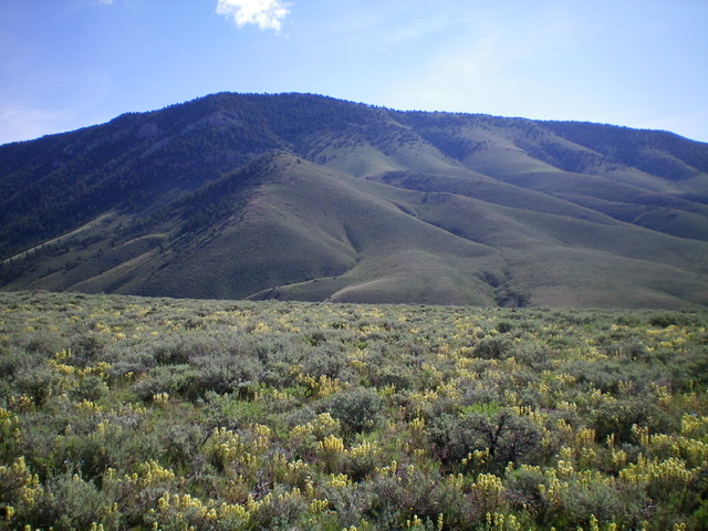
Black Mountain as viewed from the intervening ridge to its southwest. The summit is left of center as is the southwest shoulder/south face that leads up to it from Grouse Canyon. Livingston Douglas Photo
Access
From the junction of ID-22 and ID-28, drive east on ID-22 for 12.5 miles to a signed junction with Crooked Creek Road/FSR-178. Turn left/north onto Crooked Creek Road and reset your odometer. At 7.7 miles, go left at a signed junction. At 11.8 miles, reach BLM land. At 12.0 miles, go straight at a signed road junction. At 13.2 miles, reach a signed junction with Myers Creek Road/FSR-191. Go right onto Myers Creek Road and drive 1.8 miles to a signed road junction. Park here (6,741 feet). A steep, rocky mining road heads right/east from this junction. As the sign indicates, it leads to FSR-868. Myers Creek Road is a narrow, 2-track road with few pullouts but is in decent shape.
Southwest Shoulder/Southwest Face, Class 2
The Climb
In order to reach Black Mountain from Myers Creek, you must climb up over an intervening ridge and drop into Grouse Canyon. From Grouse Canyon, you can climb the west or southwest aspects of Black Mountain. From the road junction along Myers Creek Road, hike southeast up the steep, rocky mining road to reach the flat crest of the intervening ridge. This area is covered with thick sagebrush but there are multiple old roads (most unsigned) on this ridge.
Your objective is to cross this ridge and descend to Grouse Canyon. Unfortunately, there isn’t a single road that heads eastward to do this. You must wiggle your way there on a series of 2-track roads that, in combination, get you to Grouse Canyon. Fortunately, the USGS topo map shows these old roads and will help you. You can always simply bushwhack through the thick sagebrush to reach Grouse Canyon if you wish.
At the first unsigned junction you reach on the flat ridge crest area, go right/southeast. Go left/north at the second unsigned junction. Go right/east at a third unsigned junction onto a faint 2-track road. This road leads to a good jeep road (FSR-866) heading left/northeast down to Grouse Canyon. Descend FSR-866 to Grouse Canyon and a signed 3-way road junction. From this junction, hike briefly north on FSR-198 to pass a gully on the right/east side of the road and reach the base of the southwest shoulder of Black Mountain.
Leave the road and climb the steep sagebrush of the southwest shoulder (not too bad). Higher up, the terrain is easier (shorter scrub) but rockier (scree base). Reach the top of Point 7760+, a hump that is a good navigational objective on both the ascent and descent of this route. Descend northeast about 100 vertical feet to a minor saddle. Continue northeast straight up the face (soon to be forested), staying near a gully (and right/east of some rocky towers). Grind up a steep, forested slope on loose gravel/scree.
There are some diagonal elk trails to help you switchback up through the forest and reach the easy, open summit ridge just northwest of the top of Black Mountain. There are scattered trees here but no thick forest. Once on the summit ridge, it is an easy walk right/southeast to the semi-open summit of Black Mountain. The summit has triangulation posts and wiring but no USGS benchmark and no summit cairn. I built a nice cairn on top for future climbers to enjoy.
When you descend this route, finding Point 7760+ and its connecting saddle can be a challenge in the thick forest. You will get glimpses of the hump through the trees but it is difficult to hit it just right. Just work your way to it and then retrace the ascent route down to Grouse Canyon. On the return from Grouse Canyon, I followed [good] FSR-866 southeast all the way to a [signed] junction with the unnumbered jeep road that leads back to Myers Creek. Go right/northwest on that jeep road and ignore any side roads in making your way back to Myers Creek Road and your vehicle.
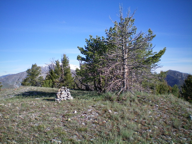
The summit area atop Black Mountain with its newly-built summit cairn. Livingston Douglas Photo
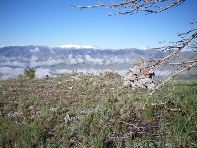
The summit view from the top of Black Mountain, looking west at the freshly snow-dusted peaks and the leftover clouds in the valleys below. Livingston Douglas Photo
Additional Resources
Regions: Beaverhead Range->EASTERN IDAHO
Mountain Range: Beaverhead Range
Longitude: -112.67019 Latitude: 44.28889