Elevation: 2,937 ft
Prominence: 350
This peak is not in the book. Published November 2022
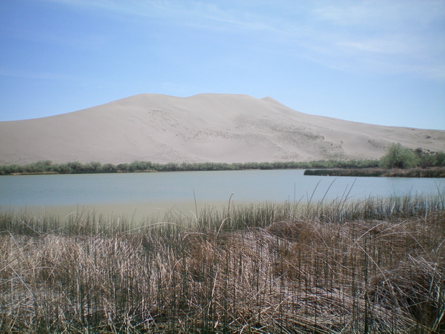
Bruneau Dunes HP is the highest point in the large sand dunes that make up the Bruneau Dunes State Park. However, it is NOT the highest point in the Bruneau Dunes State Park. That point is at 3,090 feet and is located due south of the official Bruneau Dunes HP. It is on the north edge of the Point 3229 massif and at the south edge of the border of Bruneau Dunes State Park. Bruneau Dunes HP is on a high ridge at the southwest end of the dunes massif that sits directly south of Big Lake. The [lower] northeast ridge point of the massif is only 2,835 feet in elevation.
The Bruneau Dunes as viewed from the lake. The high point is the pointed hump right of center. Livingston Douglas Photo
Access
Bruneau Dunes State Park is located off ID-78 west of Exit 112 on I-84 and east of Bruneau, Idaho. The turnoff for this State Park is well signed. There is a $7 day use fee (per vehicle) to enter the park.
Map Errors
The USGS topo map shows no hiking trails in the Park, yet there are several. Perhaps more disturbing is that the official Bruneau Dunes State Park trails map (available online and published by DeLorme) shows trails that do not exist. Most importantly, the hiking trail that follows the ridge crest of the two large dunes (the highest one is labeled “Big Dune”) does not exist. The ridge crest is a wind-blown, knife-edged crest of sand that is very difficult to hike without sliding down either side of the crest. Any footprints made in the sand are typically blown away within 5-10 minutes of placing them, even with light winds. It’s amazing.
Northwest Shoulder/North Ridge, Class 2
The Climb
From the Big Dune Picnic Area near Big Lake, follow a so-so hiking trail south-southwest to skirt the west side of Big Lake. The trail (which becomes difficult to follow since it is in soft sand) reaches a signed junction at the southwest end of Big Lake. Go right/west here and follow the hiking trail (which becomes somewhat indistinct) to reach the northwest shoulder. Leave the trail as it bends right/northwest and is part of a loop that circles back to the Small Lake/Big Lake area. Scramble up loose sand to reach the crest of the northwest shoulder.
Follow the crest of the sandy shoulder southeast as it heads toward the sandy summit ridge well above you. The summit high point is to the right/south of a prominent gully that separates the summit high point from a lower ridge point to the left/north. The shoulder steepens as you gain elevation and the sand becomes more difficult to climb. Leave the shoulder and traverse right/south across a minor gully then a minor ridge then drop right/south into a large gully. This gully heads left/east up to the critical ridge saddle that will give you the best access to the summit.

Bruneau Dunes HP (the hump right of center) as viewed from the base of the northwest shoulder. Livingston Douglas Photo
Scramble up this sandy gully (not too difficult) to reach the ridge saddle. Once on the narrow ridge, follow it right/south up a knife-edged, loose sand ridge crest to reach the high point. There is no summit cairn or any other market on the high point. Not even any footprints. You must straddle the knife edge in order to not slide down either side of the ridge crest. It is not a comfortable place to be. It is not easy to stop, drop your pack, and take photos. That is how unstable the steep sand is. But this ridge crest summit is clearly the high point of the two large dunes that sit directly south of Big Lake. It is the official high point as designated by LOJ.
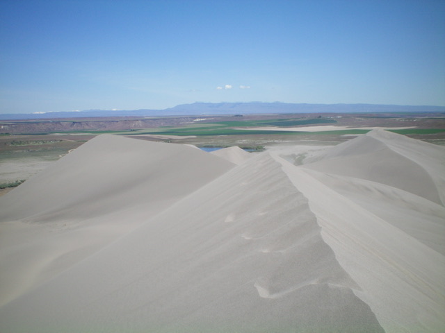
The summit view from the sandy ridgeline top of Bruneau Dunes HP, looking north. Livingston Douglas Photo
Additional Resources