Elevation: 9,643 ft
Prominence: 743
Climbing and access information for this peak is on Page 131 of the book. Livingston Douglas provided the 2024 update. Updated December 2024
Estes Mountain is a striking summit which can easily be reached from the road described below. Please be aware that much of the peak’s south slopes are part of a patented mining claim and are on private property. As a result, it is best to climb the peak via its north ridge which is accessed as described below. USGS Custer
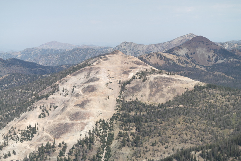
The south face of Estes Mountain as viewed from Mount Greylock
This peak has been under assault by miners since the mid-1800s. Mining on on the peak’s south face has extended nearly up to its summit. Further mining has taken place on its east side where you will find old cabins and other mining debris. Ray Brooks reports: “Mining began on Estes Mountain, which is up Yankee Fork, in 1875, when Curtis Estes discovered rich ore near the top of the 9,643-foot peak. Mining has continued at least to 2018, when I hiked up an “OK” road a few scenic miles & about 2,000 vertical feet to near the top of the mountain. A few hundred feet below the summit was a locked gate & both No Trespassing & No Hunting signs, which I respected.“
Access
The following access information expands on the access information in the book. Start on Loon Creek Summit Road [(F)(3.2) on Page 141] which begins just north of the Yankee Fork Dredge. From this road, you can access the ridge line south of Estes Peak via a road that, as far as I know, does not have a Forest Service number designation. I will designate it as FSR-3.2.2/Estes Mining Road. This road leaves Loon Creek Summit Road 5.1 miles north of the beginning of that road.
2024 Updates by Livingston Douglas
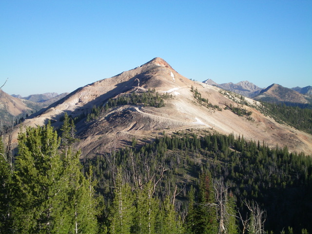
Estes Mountain as viewed from Peak 9366 to its southeast. Livingston Douglas Photo
As of Summer 2024, there was no mining activity on Estes Mountain. The mining road is not maintained as it used to be. The switchbacking mining road is gated and closed early on and has a “No Trespassing” sign on it. Contrary to the website information, the Estes Mountain Road is currently in poor shape and does not appear to be maintained. It requires a 4WD and good tires. The drive up to the east side of Estes Mountain is 3.4 miles instead of 2.4 miles as the website indicates.
From Yankee Fork Road/FSR-070, drive north up [signed] Loon Creek Road/FSR-172 for 5.1 miles to an unsigned junction with a steep, poorly-maintained 2-track road heading right/east. Reset your odometer here. At 2.1 miles, go right at an unsigned road junction. At 3.1 miles, reach a critical unsigned junction. Go left here to reach the critical 9,060-foot saddle at the base of the east ridge.
Go right here to reach a broader saddle at 8,980 feet. This saddle offers a better campsite (in the nearby pine forest) and a better launch point for a climb of Peak 9366, Peak 9380, Peak 9403, and Mount Greylock (9,857 feet). It is not a bad launch point for the climb of Estes Mountain either (as I chose to do from my campsite).
Map Errors
There are more mining roads on Estes Mountain than appear on the USGS topo map (see photo). This is due to the intense mining activity that occurred on Estes Mountain 10-15 years ago. The active mining operation is currently west of Estes Mountain, over on the west side of Jordan Creek at the “Sunbeam Mine” location on the USGS topo map.
East Ridge, Class 2
The Climb
From the 8,980-foot saddle, bushwhack northwest then west through a mix of rock and thick pine forest to reach the 9,060-foot saddle at the base of the east ridge of Estes Mountain. Barely skirt the left/south side of Point 9080+ on the way to the higher saddle. From the saddle, hike west up the mining road to quickly reach a gated road closure and “No Trespassing” sign. Continue hiking up the road (at your own risk). Leave the rocky road high up where it is a short distance underneath the rocky summit area. Scramble right/east up the rocky ridge crest to the summit.
Alternatively, you can leave the rocky mining road midway up when it crosses to the left/south side of the ridge crest at a saddle. There is a hiking trail that you will discover as you scramble north up the endless pile of talus to reach the summit. The hiking trail helps alleviate the loose, steep, arduous nature of the talus slope. I took this route on my descent from the summit.
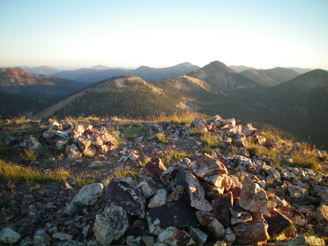
The multiple cairns atop Estes Mountain. Livingston Douglas Photo
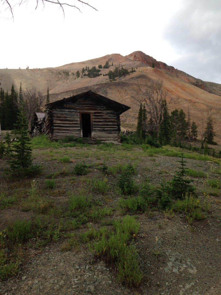
Cabins on the east side of Estes Mountain
Additional Resources
Regions: Eastern Salmon River Mountains->Salmon River Mountains->Southeast Corner Peaks->WESTERN IDAHO
Mountain Range: Salmon River Mountains
Longitude: -114.71169 Latitude: 44.44539