Elevation: 6,659 ft
Prominence: 599
This peak is not in the book. Published November 2023
Galway Benchmark is a minor hump that sits above the Freeman Creek drainage to its north. It is overshadowed by its much-higher neighbors on the Continental Divide to its east: Freeman Peak (10,273 feet) and Monument Peak (10,323 feet). Golway Benchmark is most easily climbed via an old 2-track road (and fence row) that comes up its east ridge from an unsigned Forest Service Road that departs from Freeman Creek Road. USGS Badger Spring Gulch
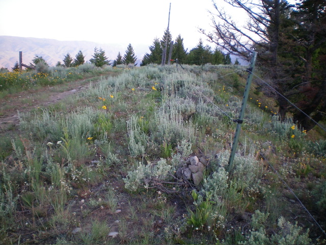
The open summit of Golway Benchmark. Livingston Douglas Photo
Access
From the Sinclair Gas Station on US-93 at the north end of Salmon, ID, drive north on US-93 for 4.0 miles to a signed junction with Carmen Creek Road. Drive east then northeast on [paved] Carmen Creek Road to a “Y” junction. Go right/east onto [signed] Freeman Creek Road. Drive 2.9 miles up narrow, somewhat-rocky Freeman Creek Road to an unsigned road junction and a large parking area. This junction is at 5,349 feet (map). Park here.
Map Errors
There are several ATV trails on the east side of the north ridge that are not shown on the USGS topo map or the Salmon National Forest map. These ATV trails provide easy access to the crest of the north ridge and are useful to hikers. The USGS topo map fails to show a jeep road heading north from the summit and another road heading west from the summit. The Salmon National Forest map shows both of these roads.
Northeast Gully/Northeast Shoulder, Class 2
The Climb
From the 5,349-foot road junction, hike about 0.6 miles south up the jeep road to a large meadow and dispersed campsite on the right/west side of the road. There is a weak 2-track heading right-ish into a gully. Follow the 2-track up the gully as it heads directly at the north ridge. The 2-track morphs into a foot trail then just ends high in the gully at the base of a steep-ish headwall of scrub. Either climb directly up the headwall onto the north ridge (a good option) or exit the gully and climb steeply up grass/scrub onto a narrow shoulder on its left/south side (another good option). I chose the latter option.
Once atop the steep shoulder, scramble southwest up through a mix of scrub, pines, and downed trees to reach the north ridge at a fence corner (and fence row) just below the summit. Follow the ridge crest (and fence row) left/southeast on a 2-track road to quickly reach the summit. The summit had no cairn so I built a small one. The high point is along the fence row and is just off the road on its east side. There was no benchmark in sight. This is a semi-open area so the high point is indisputable.
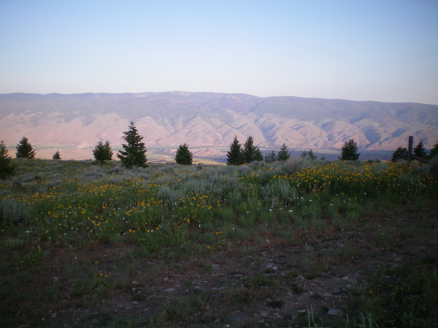
Summit view from Golway Benchmark, looking west. Livingston Douglas Photo
North Ridge, Class 2
The Descent
From the summit, descend northwest then north, following a dilapidated electric fence row. Follow the forested ridge crest as it meanders its way northward and eventually reaches a 2-track road that crosses the ridge at a fence row/gate in an open area. Follow this road right/east then northeast as it turns into an ATV trail that descends steeply to a large meadow and camping area that has multiple ATV trails emanating from it. From the meadow, follow the main ATV trail left/northeast briefly to intersect the jeep road that quickly leads north and back to the junction with Freeman Creek Road. Now knowing that these ATV trails exist so close to that junction, I would much prefer to ascend Golway Benchmark via my descent route rather than via my ascent route.
Additional Resources
Regions: Beaverhead Range->EASTERN IDAHO
Mountain Range: Beaverhead Range
Longitude: -113.7682 Latitude: 45.2513