The Gannett Hills that straddle the Idaho/Wyoming border were not included in the book. This was an oversight on my part. Livingston Douglas has provided us with both an overview of these mountains as well as routes for several of the range’s Idaho peaks.
The Gannett Hills straddle the Idaho/Wyoming state line for almost 20 miles from just south of Fairview, WY to just north of Geneva, ID. US-89 is the primary highway that connects Geneva to just east of Fairview. The Gannett Hills cover a lot of square mileage. They are found in Lincoln County in Wyoming and both Bear Lake County and Caribou County in Idaho. The Gannett Hills are in both the Bridger-Teton National Forest (WY) and the Caribou-Targhee National Forest (ID). While the northern Gannett Hills are on the west side of US-89, the middle and southern Gannett Hills straddle both sides of US-89.
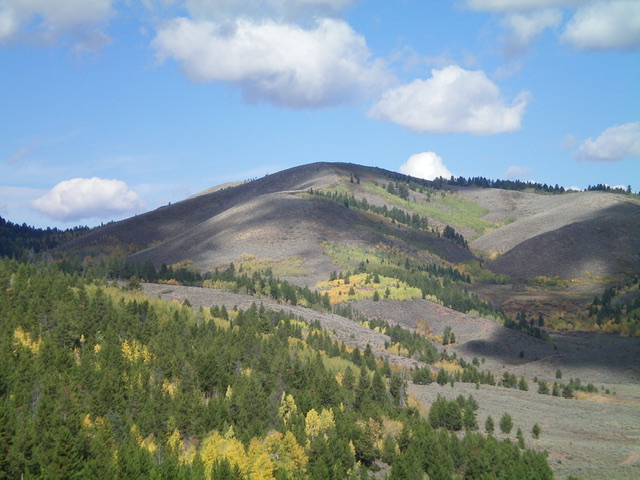
Peak 7820. Livingston Douglas Photo
The Wyoming Gannett Hills are generally much easier to reach, thanks to US-89 and side roads that emanate from it. The Idaho Gannett Hills are remote and are not so easy to climb. The north end of Idaho’s Gannett Hills are mostly on private land and access is difficult if not impossible, even via Crow Creek Road/FSR-111 due to posted, private land that blocks access to the nearby Caribou-Targhee National Forest. The south end is a mix of private and public land.
The best access is via North Loop Road (about three miles north of Geneva on US-89) and Dry Creek Road/FSR-834. Much of the Gannett Hills is roadless and most of the roads that remain are dubious at best (even Crow Creek Road in its upper section) and may require the use of an ATV or MC to get even reasonably close to a Gannett Hills summit. A backpack trip may be required to reach many of Idaho’s Gannett Hills.
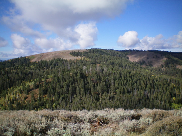
The east ridge of Peak 8140. Livingston Douglas Photo
I climbed the highest point of the Gannett Hills, Red Mountain at 8,809 feet from Crow Creek Road in 2019. I climbed four more of Idaho’s Gannett Hills in 2022: Peak 8140 and Peak 7820 from the south and Peak 8060 and Peak 8024 from the northwest. Use this link to read about these peaks: Gannett Hills Peaks.
The Gannett Hills are named after Henry Gannett (1846-1914) who was such a talented topographer that he is regarded as the “father of mapmaking in America.” He was a topographer with the USGS for over 20 years and was the chief topographer for the famous Hayden survey (during the 1872-1879 period) which mapped much of Yellowstone National Park and the western United States.
Gannett was so highly regarded that not only is his name given to the Gannett Hills of Idaho/Wyoming but also for Gannett Peak (the highest peak in Wyoming), the Gannett Glacier (near Gannett Peak), and Mount Gannett (a 9,629-foot peak in the Chugach Mountains of Eastern Alaska). Not only was Gannett a talented topographer but he was the author of numerous publications about geography and statistics. He was one of the six founding members of the National Geographic Society in 1888. For more detailed information on this amazing man, please consult the this link to the Wikipedia website: Henry Gannett.
For Idaho climbers, the Gannett Hills present a real challenge. Based on my experience, the off-trail bushwhacking is difficult in the Gannett Hills and you must be prepared to put in some mileage to reach any of Idaho’s Gannett Hills.
Regions: Gannett Hills->SOUTHERN IDAHO
Mountain Range: Gannett Hills