Elevation: 9,909 ft
Prominence: 929
Climbing and access information for this peak is on Page 323 of the book. Livingston Douglas provided the updated photos, access and route information as well as the insightful commentary found below. Updated April 2018
Goldstone Mountain is a big mountain that is located just west of the Continental Divide. It is entirely in the State of Idaho. USGS Goldstone Mountain
Goldstone Mountain . Michael Darcy Photo
Northeast Ridge, Class 2
Access
Continental Divide Trail/FST-111 via Goldstone Pass [(D)(1) on Page 331] revised and updated as follows. The shorter approach is from the Montana side of the Continental Divide and is entirely on public land. If you have an ATV, you can drive all the way to Goldstone Pass and significantly shorten this climb.
From Jackson, MT, drive south on MT-278 about a mile to the Skinner Meadows Road/FSR-381 turnoff on the right/west side of the highway. Set your odometer to 0.0. At 9.1 miles, you enter the Beaverhead-Deerlodge National Forest. Between 10.7 miles and 11.1 miles, you will pass North Van Houten CG and South Van Houten CG. At 11.6 miles, go left at a road junction to stay on Skinner Meadows Road.
At 15.9 miles, there is a lovely campsite in the trees to the left of the road. You are passing through Skinner Meadows. At 19.2 miles, you reach a triple fork in the road. Straight ahead is FSR-181/Bloody Dick Road, which goes to Reservoir Lake, MT [see page 331 in the book under (D)(1) for directions to Dillon, MT]. The right fork is FSR-7402. The double-right fork is FSR-7327/Goldstone Pass Road.
This is the road you want. It is a narrow ATV road, not suitable for passenger vehicles. Park at the triple fork and look for FSR-7327. It is a right turn about 50 feet up FSR-7402 from the triple fork. It has a small FS road sign at its start. This is the starting point for the climb to Goldstone Mountain, Goldstone North, and Goldstone West. The elevation here is 7,620 feet.
Hike up FSR-7327/Goldstone Pass Road for 3.25 miles to reach Goldstone Pass (9,100 feet). Be alert for bears along this road. I encountered a juvenile grizzly while descending this road. It was as surprised to see me as I was to see him. And it was lunchtime. Hmmm.
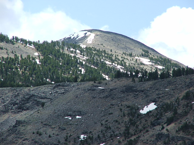
Goldstone Mountain as viewed from the southeast The summit is left of center. The long northeast ridge extends rightward from it. Livingston Douglas Photo
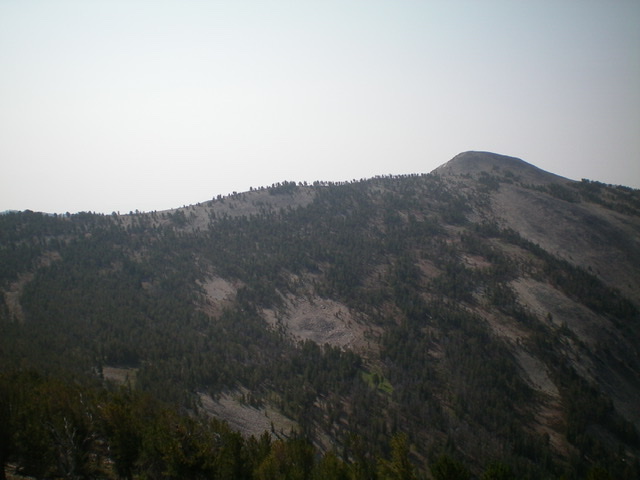
The long northeast ridge (the forested skyline in the photo) of Goldstone Mountain as viewed from the north. The summit is right of center. Livingston Douglas Photo
The Climb
From Goldstone Pass, walk about 100-150 feet west on the jeep road to find the Continental Divide Trail (CDT) south junction. Hike south on the well-maintained trail. The CDT stays in the forest on the west side of the CD and remains below the ridge crest for much of this hike. It drops just over 200 feet to a saddle (8,980 feet). For the purists out there, this saddle is the REAL Goldstone Pass, not the [higher] crossing of the ridge that is the “official” Goldstone Pass. Just saying. Continue south on the CDT, climbing almost 750 feet, up over Peak 9735. The CDT then follows the ridge crest and drops to a minor saddle at 9,420 feet.
Continue hiking south along the CDT as it ascends to the Northeast Ridge of Goldstone Mountain. Angle your way through the open forest to skirt a minor bump on the ridge that sits on the CD. Once on the ridge, the terrain opens up. Scramble southwest then south to the talus-covered summit. This ridge is an easy Class 2 stroll, requiring only 300 feet of elevation gain. Once on top, enjoy the windswept summit and pay your respects to the intrepid surveyors who established the elevation of Goldstone Mountain at 9,909 feet. The surveyors’ triangulation tripod stands tall and proud, thanks to some hard work by yours truly.
Northeast Face, Class 2+
The Descent
This route is part of a ridge traverse from Goldstone Mountain to Goldstone West then up over Goldstone North and back to Goldstone Pass. Consequently, it begins on the summit of Goldstone Mountain. From the summit, descend northward on the Northeast Face, doing a diagonal traverse down into the open forest. Don’t be tempted to descend directly down the Northeast Face into the West Fork Sandy Creek drainage. Cliff bands await you if you do. The angle is gentler the farther you traverse to the northeast. In other words, aim for the upper reaches of the West Fork Sandy Creek drainage, but don’t go too far northeast. Your goal is to reach the drainage at the 9,200-foot contour.
Cross the small, spring-fed stream and bushwhack west through the forest, moving away from the stream and dropping to the 9,000 to 9,050-foot level. Contour at 9,000’-9,050’, skirting underneath prominent cliffs on the south face of Point 9546. To avoid painful side-hilling, move left/west into a gully that leads up to the 9,060-foot saddle that sits at the base of the East Face of Peak 9725/Goldstone North. This completes the Northeast Face Route ridge traverse from Goldstone Mountain to Goldstone North. Please refer to the East Face Route of Goldstone North for the next leg of the journey (either a climb of Goldstone North or a return to the CDT just north of Peak 9735). This route was previously completed and documented by Michael Darcy.
Livingston Douglas shared his thoughts on this summit:
The summit of Goldstone Mountain is an open, windswept peak with a USGS Benchmark in a ground boulder. When I was on the summit of Goldstone Mountain, it had a wooden triangulation tripod laying on the ground, inevitably doomed to rot away. In addition, there were the usual rusty guywires strewn about the summit. Climbers often find remnants of the triangulation equipment on tops of summits where the intrepid geological surveyors did their assessments of the elevations of various mountains in the area. Lugging their survey equipment to the tops of the mountains in the Western United States must have been a real challenge. We have things much easier today than they did.
Once in a great while, rather than finding a few scattered pieces of wood and rusty wires, you will find a relatively-intact triangulation tripod. That’s what I found atop Goldstone Mountain. Rather than leave the 5-foot wooden tripod to rot on the ground, I stood it back up, secured its rickety legs with talus, and even placed a good piece of talus atop the flat platform to hold it in place in the event of fierce winds. I did this in honor of the courageous surveyors who, many years before us, mapped the Western mountains and established the elevations of so many peaks and points that we take for granted. When you visit the summit of Goldstone Mountain today, you’ll see the triangulation tripod standing tall as it should. The tripod will serve as a landmark for those who love the outdoors and as a resting point for local hawks and eagles as they ready their wings for their next flight.
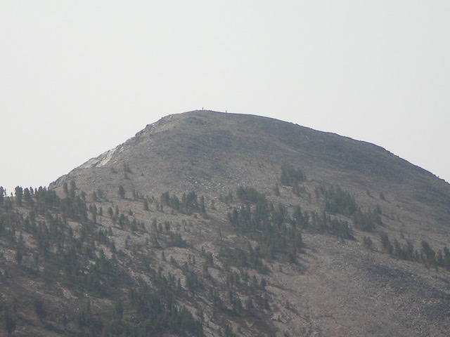
The summit of Goldstone Mountain as viewed from the north. The two stick figures standing on top are Gerry Roach and his wife Jennifer Roach, two of Colorado’s most accomplished mountain climbers. I met them earlier in the morning. Livingston Douglas Photo
Additional Resources
Regions: Beaverhead Range->EASTERN IDAHO
Mountain Range: Beaverhead Range
Longitude: -113.57629 Latitude: 45.11879