Elevation: 5,740 ft
Prominence: 1,668
Climbing and access information for this peak is on Page 56 of the book. Published November 2023
Graham Mountain is a big mountain that is located on the southeast side of the Coeur d’Alene River in the Coeur d’Alene Mountains north of I-90. It is most easily reached via its southwest spur and west ridge on an old, poorly-maintained trail in the thick forest. Please note that the official elevation of Graham Mountain is 5,740 feet, slightly higher than the 5,727-foot elevation stated in the book. USGS Kellogg West
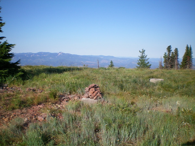
The open summit of Graham Mountain with its newly-built summit cairn. Livingston Douglas Photo
Access
From Exit 43/Kingston on I-90 southeast of Coeur d’Alene, go north on CR-9 for 8.0 miles to an unsigned junction with a gated road on the right/east side of the paved road. Go sharply right onto this dirt road as it heads south then north then southeast up a series of switchbacks. The road is narrow but is decently maintained due to logging activity. Ignore any side roads until the road reaches a 3-way junction. Park at a gated road closure just past this junction at a 2-track road that heads west. This is old FSR-606 (still shown on the USGS topo map) but has been closed to motor vehicles for years. This gated closure is at 4,005 feet and 47⁰35’46”N, 116⁰09’47”W.
Map Errors
There are several logging roads in this area that are not shown on the USGS topo map or the National Forest Map. The “foot trail” shown on the USGS topo map does not cross the 3-way junction. If it ever reaches the main north-south road, it does so farther north. But I could not find any place where it reached the road, so I had to search to find it. The “foot path” is hardly a trail. It is poorly maintained, is weak and overgrown in several sections higher up, and can easily be confused with game trails.
Southwest Spur/West Ridge, Class 1-2
The Climb
From the nice, shaded parking area at the gated closure, walk northeast a short distance back to the road junction. Hike a short distance north on the main road (that comes south from CR-9) to find an unmapped logging road that heads right/east. Follow this side road for 0.1-0.2 miles to an unsigned junction with an overgrown, branch-strewn 2-track road heading left/northeast toward the ridge crest. Bushwhack up this overgrown mess to its quick end at the start of the obvious foot trail in a clearing/meadow. A clearing (and the remains of an old road) head west from here and may intercept the main north-south road, but I can’t be sure. I saw nothing along the main road.
From the clearing, hike up the steep, narrow, rocky (initially) trail through thick foliage as it soon moves to the left/north side of the ridge crest as the USGS topo map indicates. Higher up, the trail bends right/east and moves to the right/south side of the ridge crest where the ridge is quite rounded and is more of a face. The trail bends left/northwest and climbs steeply (with switchbacks) through an area with a lot of deadfall. It is very easy to lose the trail here as the trail has not been cleared recently.
At about 5,200 feet the southwest spur merges into the west ridge, but you probably won’t recognize it. The trail climbs northeast up to the crest of the west ridge at about 5,280 feet and intercepts an old ridge road. Follow this old 2-track road east to the open summit. The summit has some concrete pilings and the wreckage of an old fire tower or cabin. I built a nice summit cairn atop the highest concrete footer. I lost the trail on the descent (in the section of heavy deadfall on the south side of the ridge) and had a tedious forest bushwhack to find the trail again. Consequently, my descent was Class 2.
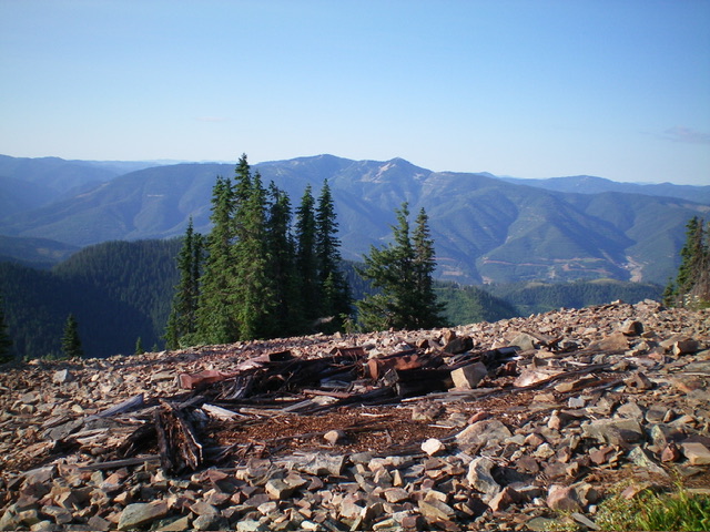
Summit view from atop Graham Mountain with building/tower wreckage in the foreground. Livingston Douglas Photo
Additional Resources
Regions: Coeur d'Alene Mountains->NORTHERN IDAHO
Mountain Range: Coeur d'Alene Mountains
Longitude: -116.1353 Latitude: 47.6035