Elevation: 8,780 ft
Prominence: 1,480
This peak is not in the book. Livingston Douglas replaced the original page with an extensive and much improved update. Updated November 2023
Haystack Mountain is located at the headwaters of both Pine Creek and Moose Creek deep in the Eastern Salmon River Mountains. The summit has a repeater station on top in a vast talus field on the edge of a pine forest. The high point appears to be in the talus field a short distance from the repeater. A ridge road leads to near the summit. USGS Pine Creek Ridge
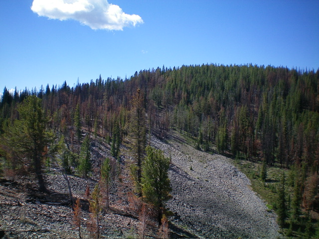
Haystack Mountain (summit is right of center) and its northeast ridge (left of center) as viewed from Point 8561. Livingston Douglas Photo
Access
From the Sinclair Gas Station at the north end of Salmon on US-93, drive 3.1 miles north on US-93 to a signed junction with Diamond Creek Road at the Lemhi County Fairgrounds. Turn left/west onto Diamond Creek Road and reset your odometer. At 0.5 miles, the road bends hard right/north. At 0.8 miles, reach a “Y” junction. Go left onto [signed] FSR-023. At 11.6 miles, reach a 4-way signed junction on a saddle.
Reset your odometer at this junction. Continue west on FSR-023. At 3.7 miles, reach a signed junction with FSR-406 (right). FSR-023 bends left/south here and then bends right/west to reach a signed junction with FSR-300 (left). Continue straight/west on FSR-023. At 9.2 miles, reach a signed junction with an ATV trail on the right (FSR-023H/FST-6068). This side road is not shown on maps. Park along FSR-023 at this junction (7,670 feet; 45⁰18’17”N, 114⁰06’48”W). This junction sits just east of Big Boulder Meadow, which is visible from the junction.
Map Errors
Both the Salmon National Forest Map and the USGS topo map show FSR-023 as a decent road but it is badly rutted for the first two miles past its junction with FSR-300. The USGS topo map shows a jeep road that leads from FSR-023 to FST-214 but that road no longer exists. I found remnants of the old road in the thick forest, but it doesn’t reach FSR-023 so it isn’t of much use.The Salmon National Forest map shows FSR-023H as FST-6068 (though the road is signed as FSR-023H). The Salmon National Forest map fails to show the summit ridge/service road on the high ridge that leads south to Haystack Mountain.
Both the USGS topo map and the Salmon National Forest Map show FST-214 crossing FSR-023 near Big Boulder Meadow.However, FST-214 is not maintained and is very difficult to follow. In some areas, it just doesn’t exist anymore or is so covered with deadfall that it is impossible to follow. I was counting on FST-214 taking me west up to the ridge crest north of Haystack Mountain and I was sadly disappointed. FST-214 is not visible at FSR-023. Remnants of it are along FSR-023 heading into the thick forest at about the 9.0-9.1 mile mark from the 4-way signed junction (or 0.1-0.2 miles south of the signed junction with FSR-023H/FST-6068). There are no trail signs for it on either side of FSR-023.
East Spur/Northeast Ridge, Class 2
The Climb
From the road junction, bushwhack west for a short distance and descend 10 feet to reach Big Boulder Meadow. Big Boulder Meadow is a grassy, somewhat marshy meadow that sits at the base of the east spur. Follow the edge of the meadow southeast briefly then head southwest across field grass (jumping across small marsh streams as necessary) to reach a pine forest at the toe of the east spur. Bushwhack southwest up a forested shoulder (not too bad) then follow the forested shoulder southwest then west then southwest to flattish Point 8280+.
Continue west and drop five feet to a minor saddle in a mix of charred and live pines. From the saddle, head west up through a charred pine forest and, at some point, find the remains of FST-214. Follow FST-214 as the forest changes from a burn area to a live pine forest. FST-214 puts you onto the burnt ridge crest northeast of Haystack Mountain. Leave the trail and follow the semi-open ridge crest south to a saddle, dropping 30 feet on the way. Enter a live pine forest here and continue south-southwest on the ridge crest with a relatively easy bushwhack. Pick up the ridge road as it comes up from the west to reach the ridge crest.
Follow the ridge road southwest to skirt the west side of Point 8561, crosses a talus field, and descends 30 feet to a minor saddle. There is an unsigned road junction (not shown on maps) here. Go right/west to stay on the ridge road. Follow the old road all the way to the repeater installation atop Haystack Mountain. There was no summit cairn here in the large talus field next to the pine forest. I found a torn-down cairn in the nearby forest (about the same elevation) but could not find a USGS benchmark there. I walked around a bit and found that the high point seems to be a slight rise just east of the repeater station. I built a large summit cairn there.
Return back to FST-214 and follow it east then northeast down the east spur. It has sections where it is very difficult, if not impossible, to follow. I lost it a few times. Lower down, it became impossible to follow but I stumbled on an old mining road heading north toward FSR-023. I followed it but it became overgrown with brush and buried in deadfall, so it wasn’t of much use. I had a short, thick forest bushwhack back to FSR-023 and came out near a bend in the road about 0.1-0.2 miles south of the road junction where I was parked. I also saw a weak trail heading into the forest about 50-75 feet north of where I popped out on the road. Perhaps this is the remnants of FST-214 at FSR-023. But, given how thick the forest is, I doubt that in this area the old trail will get you very far.
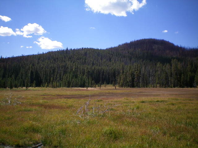
Big Boulder Meadow and the east spur above it. This is where my climb of Haystack Mountain began. Livingston Douglas Photo
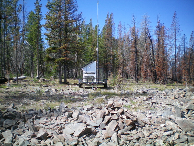
The newly-built summit cairn atop Haystack Mountain with a portable repeater station nearby. Livingston Douglas Photo
Additional Resources
Mountain Range: Eastern Salmon River Mountains
Year Climbed: 1984
Longitude: -114.15349 Latitude: 45.28449