Elevation: 8,780 ft
Prominence: 920
Climbing and access information for this peak is on Page 370 of the book. Published November 2020
Little Elk Mountain is located at the head of Deadman Creek. It is overshadowed by Big Elk Mountain (9,476 feet) to its northeast. With almost 1,000 feet of prominence, however, Little Elk Mountain should not be overlooked and can be combined with a climb of nearby Peak 8323. It is most easily reached by FST-130 which crosses the summit. FST-130 is reached via the Great Western Trail/FST-552 from McCoy Creek Road. USGS Big Elk Mountain
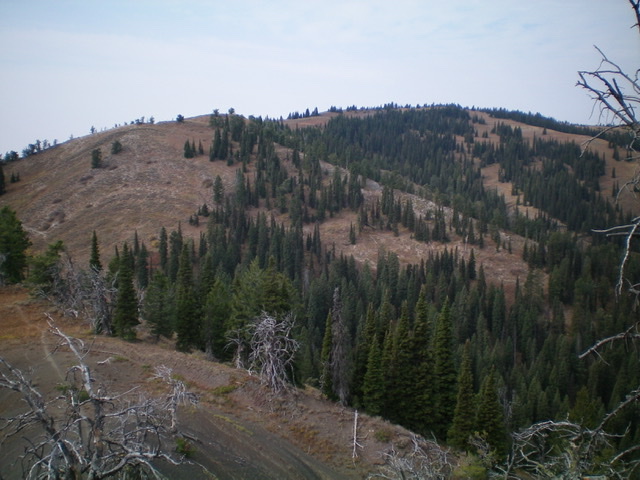
Little Elk Mountain as viewed from the east. The summit is right of center. Livingston Douglas Photo
Access
From the junction of US-89 and Greys River Road in Alpine, WY (Alpine Market and Family Dollar are nearby), drive south on US-89 for 3.1 miles to a [signed] junction with McCoy Creek Road. Turn right/west onto McCoy Creek Road/FSR-087 and reset your odometer. At 6.6 and 6.8 miles, reach the two entrances to the McCoy Creek Campground. At 19.2 miles, reach a junction with [signed] FSR-164. Go right/north onto FSR-164 and drive 0.7 miles to the large parking area and signed trailhead for the Great Western Trail/FST-552. Park here (6,290 feet). Please note that Wolverine Creek Trail/FST-164 (Page 372 of the book) no longer exists and is not a viable option for climbing Little Elk Mountain. Also note that FST-130 (the trail to the summit of Little Elk Mountain) is not shown on the USGS topo map.
South Spur/East Ridge, Class 1
The Climb
From the trailhead, hike up the Great Western Trail/FST-552. It immediately descends 70 vertical feet to cross two creeks (McCoy Creek and Clear Creek). Neither crossing has a footbridge or logs/boulders but the creeks aren’t too deep. Just look for a spot to jump across (or walk through) each creek. Follow the trail as it meanders its way northward across dry gullies and shoulders in open terrain. The trail bends left-ish/northwest and enters a pine forest. At about 6,820 feet, the trail reaches an unsigned junction at a ridge crossing.
This junction shows up on the USGS topo map but is not shown on the Caribou-Targhee National Forest Map. DO NOT GO STRAIGHT ON THE WELL-BEATEN TRAIL. Go left/northwest up a weaker trail that heads steeply up onto a ridge. Believe it or not, the weaker trail is the Great Western Trail. The other, well-beaten trail heads north to the upper reaches of Wolverine Creek. The Great Western Trail quickly regains its definition and follows the ridge crest northwest and skirts the north side of a ridge corner point (Point 7600+) to drop to a forested saddle at 7,540 feet.
The trail now heads north up the ridge (which initially is more of a face here) and skirts the left/west side of a large ridge hump. It continues north to an unsigned trail junction (cairn here). Go left/northwest here onto FST-130. Follow FST-130 northwest then west to the summit of Little Elk Mountain. The summit is an open area with no summit cairn. A dead, twisted pine tree is the high point and is about 20 feet off the trail.
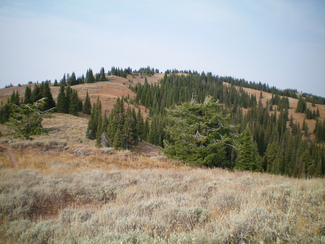
Looking up the east ridge of Little Elk Mountain. Livingston Douglas Photo
Please be advised that the Great Western Trail is a narrow foot trail that can be confused with spurious cattle trails lower down. Higher up, there are a couple of large downed trees that cover the trail and require circumventing in thick brush. It is easy to lose this trail if you are not careful. The USGS topo map correctly positions the trail, so carry that map with you. If you lose the trail higher up (in open terrain), just return to the ridge crest and pick up the trail later when it becomes more obvious.
East Ridge/East Face, Class 2
The Descent
From the summit of Little Elk Mountain, descend FST-130 to a flattish hump where the trail turns right/south. Leave the trail here (8,460 feet) and descend east then northeast down a steep, open slope of scrub and scree to reach a visible saddle (and trail) below at 8,020 feet. This is the connecting saddle with Peak 8323. It concludes the first leg of today’s two-peak journey. Peak 8323 is up next.
Additional Resources
Regions: Caribou Range->SOUTHERN IDAHO
Mountain Range: Caribou Range
Longitude: -111.32189 Latitude: 43.21439