Elevation: 6,789 ft
Prominence: 729
Climbing and access information for this peak is on Page 60 of the book.
The Forest Service states of this peak: “Part of the Marble Creek trail system. This trail has a gradual ascent to an abandoned lookout tower. However, much of the route is a fairly level grade atop a high ridge which provides the hiker with expansive views of the entire Marble Creek area and the Little North Fork of the Clearwater River plus Fish and Lost Lakes. Along the trail in the forested areas below Lookout Mountain, there are several campsites. Excellent elk habitat. There is a spur trail to Fish Lake from Trail #52. Open to motorbikes but recommended for advanced riders.”
The peak can be hiked via FST-52. Depending on which trail you begin, it will be 4 to 5 miles round-trip. Widow Mountain (6,826 feet) is located just south of Lookout Mountain and can also be climbed from FST-52. USGS Widow Mountain
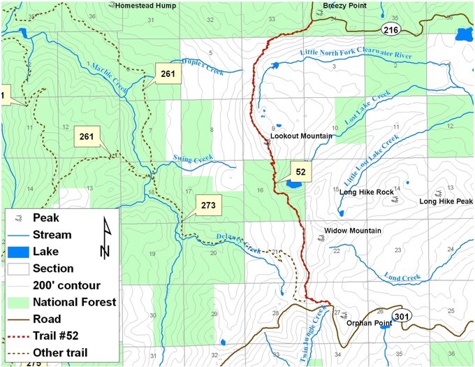
Forest Service map of the Widow Mountain area.
Access
FST-52, Lookout Mountain National Recreation Trail [(B)(2)(b) Pages 74-75. Note; This trail was called the Window Mountain Trail in the book.
The following are updated directions from the Forest Service:
From St. Maries, Idaho follow Forest Highway 50 to Forest Road 321 at Marble Creek. Take Forest Road 321 up Marble Creek to Forest Road 216. The trailhead is off the south side of Forest Road 216 near Breezy Point.
From Clarkia, Idaho follow Forest Road 301 to the trailhead of Trail 273 near Orphan Point. Follow Trail 273 a short distance to its intersection with Trail 52.
Additional Resources
Mountain Range: Northern Clearwater Mountains
Longitude: -115.9668 Latitude: 47.0830