Elevation: 7,990 ft
Prominence: 290
This peak is not in the book. Published January 2023
Mahogany Ridge West is a minor bump at the south end of Mahogany Ridge in the Big Hole Mountains northwest of Victor. Why it is labeled “West” rather than “South” befuddles me. The high point of Mahogany Ridge is Henderson Peak (8,312 feet) to its northeast. This is the first leg of a 4-peak trek that includes Mahogany Ridge West, Horse Heaven (8,260 feet), Henderson Peak (8,312 feet), and Patterson Ridge (7,621 feet). It covers 9.5 miles with 2,750 feet of elevation gain round trip. USGS Garns Mountain
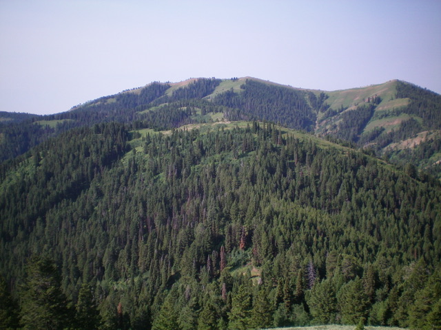
Mahogany Ridge West (hump in mid-ground) as viewed from the northeast. Livingston Douglas Photo
Access
The Patterson Creek Trailhead is located at the end of 6750W, west of Victor. To reach 6750W from ID-31 at Pine Creek Pass, follow these instructions. From Pine Creek Pass, drive 4.7 miles east on ID-31 to [signed] S2000W. Turn left/north onto S2000W and drive 0.9 miles to [signed] W8000S. Turn left/west onto W8000S (“Cedron Road” on the USGS topo map) and drive 2.5 miles west to a sharp right/north bend in the road. The road now becomes [signed] S4500W. Drive north on S4500W for 0.9 miles to [signed] 6750W. Turn left/west onto 6750W and drive 1.0 miles to the parking area and the start of FST-237, an ATV trail. Park here (6,225 feet). GPS coordinates: 43⁰37’23”N, 111⁰12’39”W.
North Ridge, Class 2
The Climb
From the small parking area, hike northwest up FST-237, a miserable trail for hikers. It crosses Patterson Creek several times at wide, shallow spots and has numerous easier creek crossings farther upstream. After about a mile of hiking, reach a signed junction with FST-218 (straight) and FST-211 (right), both of which are MC trails. Go straight onto FST-218. After another 1.5 miles, reach an unsigned junction with the old Government Fork Trail (left). Stay straight on FST-218 and follow it all the way to Mahogany Ridge and a 7,620-foot saddle at the head of the Patterson Creek drainage.
The final uphill section is ridiculously steep and loose with gravel. MCers might like this section, but hikers won’t. Upon reaching Mahogany Ridge, there is a [signed] “T” trail junction (FST-235). This is a decent MC trail on the ridge crest and will help in reaching the first three peaks of today’s journey. Go left/south onto FST-235 and follow it until it reaches open, easy terrain just past the high point of Mahogany Ridge West. FST-235 has a steep, narrow section of loose gravel/sand, so be cautious on the descent. Leave the trail and scramble right/west up easy, gapped scrub to the south ridge.
Follow the ridge a short distance north to the ridgeline summit. The ridge crest has some willows and brush to navigate, but it is only a short section and isn’t too bad. The summit is an open hump on the ridge crest and has a small cairn. Return back to the 7,620-foot saddle at the head of the Patterson Creek drainage and the signed trail junction. This is the connecting saddle with both Henderson Peak and Horse Heaven. It concludes the first leg of today’s 4-peak adventure. Horse Heaven is up next.
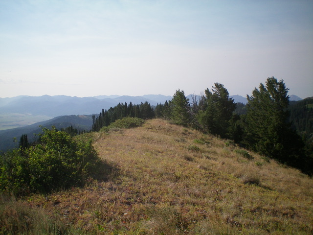
The summit of Mahogany Ridge West. Livingston Douglas Photo
Additional Resources
Mountain Range: Big Hole and Snake River Mountains
Longitude: -111.26389 Latitude: 43.64669