Elevation: 8,938 ft
Prominence: 398
Climbing and access information for this peak is on Page 128 of the Book. The information in the book about this trail is outdated and inaccurate. Published November 2023
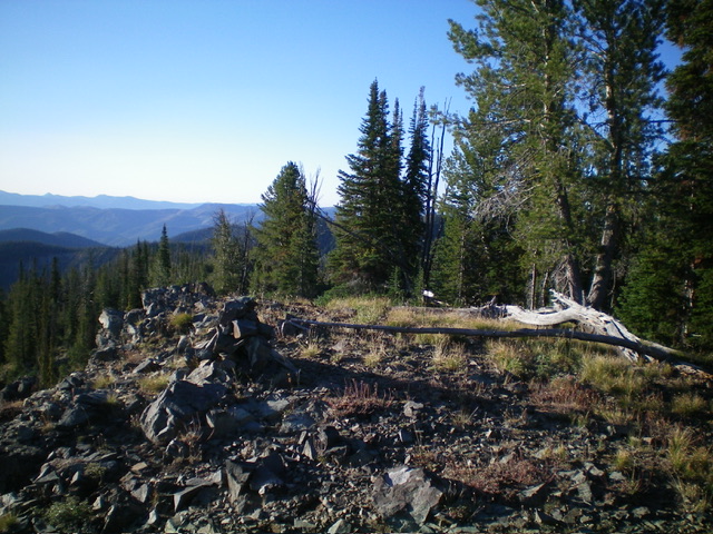
McEleny Mountain is the high point on a forested ridge located southeast of Hoodoo Meadows in the Yellowjacket Mountains. It can be reached by an unmaintained trail on the west face and a short bushwhack to the ridgeline summit. The summit offers beautiful views of the surrounding area. USGS Hoodoo Meadows
The summit of McEleny Mountain. Livingston Douglas Photo
Access
From Panther Creek Road, drive west up FSR-112/Porphry Creek Road for 6.8 miles to a signed 4-way road junction. From the road junction, head right/north up FSR-113 for a rugged, rutted 8.3 miles to a signed junction with FSR-114/Yellowjacket Lake Road. The road bends west then south along the way. Go straight/south onto FSR-114. At 4.9 miles, reach the [signed] turnoff for the Yellowjacket Lake Campground. At 6.4 miles, reach the end of the road at the south end of Hoodoo Meadows. There are two trailheads. Park here (8,205 feet; 45⁰03’12”N, 114⁰33’46”W).
Map Errors
FST-039/McEleny Mountain Trail is poorly signed and is no longer maintained. It does NOT climb the north ridge of McEleny Mountain as the USGS topo map indicates and does NOT get close to the summit. The positioning of FSR-039 on the USGS topo map is completely inaccurate. In addition, there is no trail on the ridgeline heading southeast from the summit of McEleny Mountain as the USGS topo map indicates.
West Face, Class 2
The Climb
From the road’s end, go left/southeast up a poorly-signed trail for “McEleny Mountain.” This is FST-039 and has been re-routed significantly from where it used to be. FST-039 is no longer maintained. It has numerous rocks and branches on it and has several large trees laying across it. It is difficult to follow in the open meadows. The trail heads southeast across several gullies and shoulders. It drops to a low point where it crosses the largest gully (the gully drops to the right/west).
From that low point, the trail bends right/south to contour diagonally upward across the west face, well below the north ridge to its left/east. The trail climbs a dry gully high up and pops out on the southwest ridge of McEleny Mountain. It emerges from the forest here and into a patch of open grass. There is a cairn here. There is another cairn about 100 feet farther east in the open terrain. These cairns are critical in finding the weak trail when you descend from the summit.
I was so concerned about not being able to find these cairns that I ran my GPS at the [higher] second cairn (8,820 feet; 45⁰02’42”N, 114⁰33’01”W). This cairn is on the open terrain of this section of the southwest ridge, which is 120 vertical feet from the summit of McEleny Mountain. Contrary to the IACG website, it is NOT “a short stroll to the top.” From the second cairn, bushwhack east across the open field grass to reach the forested summit cap.
Enter the forest and bushwhack east to the summit. The summit is on a high ridgeline and is partially open. The high point is either a forested bump just north of the open, rocky ridgeline or the ridgeline itself (a high boulder). These two points are within 50 feet of each other. The high boulder had a minimal cairn atop it so I built a better cairn on it. When you descend west through the forest, be very careful to not get off route.
It is surprisingly difficult to find the open terrain and the two cairns since the forest is dense and offers no visibility. The trail is so weak at its unceremonious end that it is somewhat difficult to find it even with the cairns at its terminus. I added rocks to both cairns to assist future climbers in locating the pathetic, unmaintained trail. FST-039 has an additional 150 feet of elevation gain roundtrip due to ups and downs along the way.
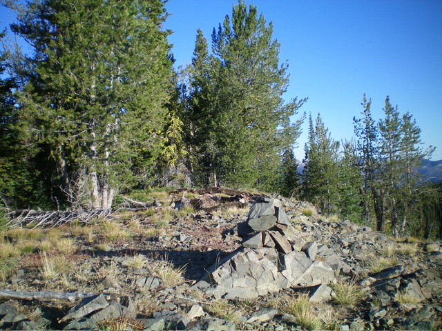
The enlarged summit cairn atop McEleny Mountain. Livingston Douglas Photo
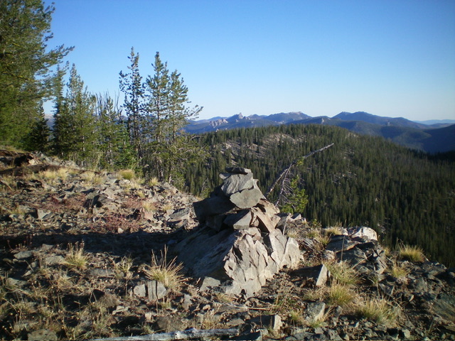
View of the Bighorn Crags from atop McEleny Mountain. Livingston Douglas Photo
Additional Resources
Regions: Eastern Salmon River Mountains->Salmon River Mountains->WESTERN IDAHO->Yellowjacket Mountains
Mountain Range: Eastern Salmon River Mountains
Longitude: -114.5444 Latitude: 45.0288