Elevation: 8,719 ft
Prominence: 819

This peak is not in the book. Published October 2025
Middle Mountain is a big mountain that sits southeast of Antelope Pass in the White Knob Mountains. It separates the Middle Fork Cherry Creek from the Left Fork Cherry Creek. USGS Shelly Mountain
Middle Mountain as viewed from the northeast. Livingston Douglas Photo
Access
From US-93 about 10.8 miles northwest of the US-93/US-20 junction in downtown Arco, turn left/southwest onto [signed] Antelope [Creek] Road. Drive 10.8 miles on this well-maintained county road to a signed junction with Cherry Creek Road just before a bridge crossing of Antelope Creek. Reset your odometer here. Drive west on Cherry Creek Road for 2.7 smoothly-graded miles to an unsigned road junction.
Go right/northwest at this junction to continue up Cherry Creek Road. The road now becomes a rough, narrow 2-track road. Reset your odometer at this junction. At 4.8 miles, reach an unsigned junction with a 2-track spur road (FST-4335) heading left/west. Go left onto this spur road and drive 0.1 miles to its end at an old corral. Park here [6,514 feet; 43°44’47.7”N, 113°40’47.7”W].
Approach via Left Fork Cherry Creek, Class 3
The Approach
The crux of this climb is how best to get to the mouth of Little Rough Canyon. It is about a mile from FST-4335 and the Left Fork Cherry Creek drainage is a willow-laden mess. You can avoid most of the willows by staying on the north side of the creek but you must contend with several rocky outcrops along the way which are a bit challenging.
From the parking spot, follow a cattle trail on the right/north side of the willows from the corral. Cross a feeder stream on a cattle trail through the willows then skirt below an initial rocky buttress on a narrow cattle trail on the north side of the Left Fork Cherry Creek. Continue west, following the Left Fork Cherry Creek. Scramble across a rocky buttress (Class 3) to avoid marshy ponds along the Left Fork Cherry Creek.
Once past this buttress, follow a cattle trail on the north side of Left Fork Cherry Creek (staying just right/north of the willows) to reach the mouth of Little Rough Canyon. Keep going west, passing 2-3 false canyons along the way, until you reach the correct canyon. This concludes the approach.
Little Rough Canyon/East Face/Southeast Ridge, Class 2
The Climb
From the mouth of Little Rough Canyon, follow old cattle trails and elk trails northwest then west up the drainage. This canyon has a small stream in it at times. This drainage leads up to the east face of Middle Mountain. Scramble west up through easier, shorter scrub/grass without the help of cattle/game trails to reach the rounded southeast ridge. Follow the open ridge northwest to the summit. This ridge gets rockier high up and the summit hump is not visible until you reach a flattish ridge area at 8,600 feet.
The summit hump has a nice cairn and triangulation post. There is no USGS benchmark. This is the highest point for MILES. The east ridge may be a better option to climb Middle Mountain. Drive another mile up Cherry Creek Road to reach its base. While this avoids the mess around the Left Fork Cherry Creek, it does require a drop to cross Cherry Creek proper, which has its own issues with willows. But this route is much shorter than the route that I chose.
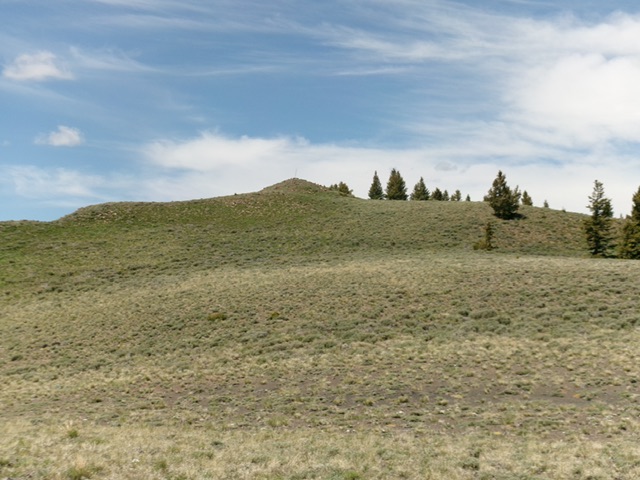
The elusive summit hump of Middle Mountain finally comes into view. Livingston Douglas Photo
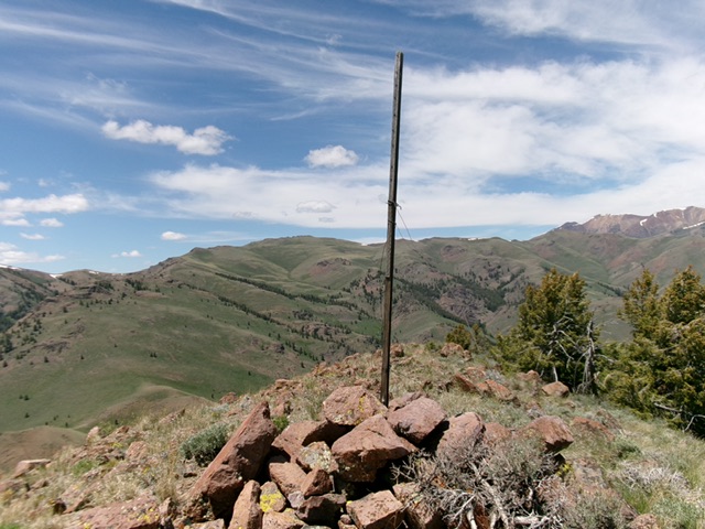
The triangulation post and cairn atop Middle Mountain. Livingston Douglas Photo
Additional Resources
Regions: EASTERN IDAHO->White Knob Mountains
Mountain Range: White Knob Mountains
Longitude: -113.7333 Latitude: 43.7569