Elevation: 10,025 ft
Prominence: 1,725
Climbing and access information for this peak is on Page 339 of the book. There are a lot of updates set out below. Livingston Douglas and Margo Mandella provided corrections for the north ridge route and important additions to the book’s text for trail access to Mount Baird’s Class 2 northwest ridge. Ken Jones described this route in his 2001 trip report. Finally, Livingston added his northwest face/northwest ridge, a Class 2-3 route variation to the mix of climbing options and a route on the southwest ridge for those interested in traversing to Elkhorn Peak. All of this information should help you successfully summit and enjoy Mount Baird. USGS Mount Baird. Updated November 2024
Mount Baird, the Bonneville County High Point and the highest peak in the Snake River Range, is a gorgeous mountain with expansive views. This page augments the information found in the book, which focuses on the north ridge route. USGS Mount Baird
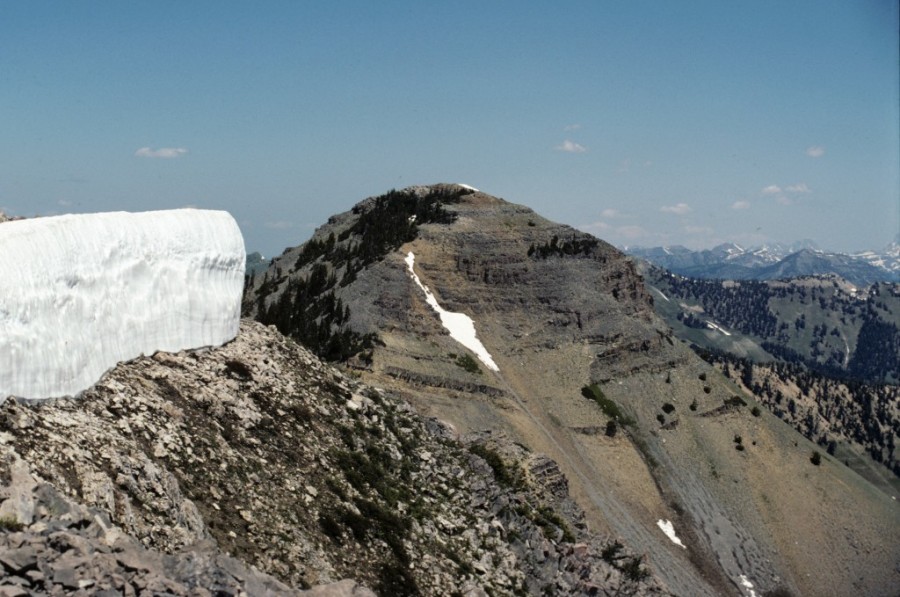
Mount Baird as viewed from Elkhorn Peak.
Access
Trail access for the north and northwest ridge routes, and the northwest couloir/northwest ridge variation, use FST-151 as presented on Page 341 and updated in this section.
- For the Little Elk Creek Access, (A)(5), the text should read “…turn right on the good gravel road” (not left; if you turn left, you’ll need a boat!). You should “follow this road to its end.” This road ends in exactly 1.4 miles and reaches two trailheads, which can be confusing. FST-100 goes left and is marked “Sheep/Little Elk Creek Trail,” which is misleading since FST-100 has NOTHING to do with Little Elk Creek. FST-100 goes up Spring Run Canyon then over to a trail junction with Little Sheep Creek Trail (at the head of the Little Sheep Creek drainage) and continues northwest and drops to Sheep Creek Road where it ends. FST-100 is an ATV trail; hikers be alert. FST-151 (Little Elk Creek Trail) is the trail that gets you close to Mount Baird.
- For the Little Elk Creek Trail description, (A)(5)(a), the text should point out that, from the dual trailhead at the end of FSR-268, FST-151 goes right and follows Little Elk Creek in a northeasterly direction and will get you close to the Northwest Ridge of Mount Baird.
- The trail is not “well-maintained,” as the first 0.5 mile of the trail was destroyed by a flash flood. Walk in the gravelly creek bed itself (be vigilant in looking for cairns) until you reach the undamaged trail higher up.
- Additionally, the trail does not go “to a pass just east of Mount Baird in just over 3 miles.” FST-151 actually goes to a 9,180-foot pass northwest of Mount Baird, which overlooks, and continues into, Waterfall Canyon. And it’s closer to 4-1/2 miles, rather than 3 miles, to the pass. Consult the Mount Baird quadrangle to visualize the trail position.
North Ridge Route, Class 3
With respect to the description for Mount Baird (Page 339) and the Little Elk Creek Trail approach (Page 341) for the north ridge, please note:
- “Take the trail to the saddle west of the peak” should state: “Leave the trail around the 8,840-foot contour (a small basin) and scramble southeast into a large basin. Then, climb east up the steep, forested headwall to reach the Peak 9722/Mount Baird saddle.” Continue with the book’s directions on the north ridge to the summit.
Northwest Ridge, Class 2
Route
Mount Baird showing the full Northwest Ridge Route (right) and the North Ridge Route (left). Todd Schwarz Photo
Once on the Little Elk Creek trail, please note:
- For the northwest ridge approach, leave the trail when you reach a small basin around the 8,840-foot contour, which is northwest of the peak. This area sits at the base of the Northwest Ridge. The northwest ridge can be reached and ascended from this point as described in Ken Jones’ trip report below.
Trip Report by Ken Jones
I climbed Mount Baird on July 6, 2001. Via the Little Elk Creek Trail, one can also head to the Class 2 northwest ridge and the Class 3 north ridge.
Take US-26 near the northwest end of Palisades Reservoir (about halfway between MP390 and MP391). Turn north on the signed Little Elk Creek Road. Follow this road (suitable for passenger vehicles) to its end (~1.5 miles), where a sign indicates the Sheep Creek ATV trail to the left and the Little Elk Creek trail to the right.
Follow the trail up Little Elk Creek to a basin at about 8,800 to 8,840 feet. Turn right on an unmapped trail, which passes around the east side of a 8,920-foot knoll. Leave the trail and pick up the northwest ridge of Mount Baird, which you can follow to the summit. This route is Class 2, though a bit steep in spots near the top. Tom Lopez’s book suggests the north ridge, which would be accessible from the same basin, but lists it as Class 3. We stuck to the northwest ridge for both the ascent and descent.
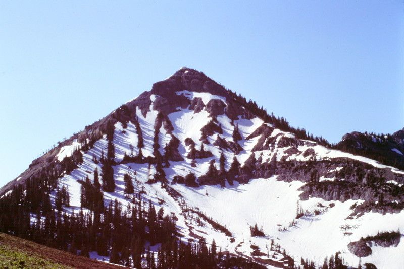
Both of the ridges pictured here are Class 3 scrambles.
Northwest Face/Northwest Ridge and Southwest Ridge to Elkhorn Peak
Northwest Face/Northwest Ridge, Class 2-3 by Livingston Douglas
This route is a variation of the northwest ridge route described in the book (Page 339) and in Ken Jones’ 2001 trip report.
The Climb
Hike up the Little Elk Creek Trail/FST-151 to a sharp left turn in the trail at a small basin (8,840 feet). The base of the northwest ridge is convoluted and imposing. The unmapped trail referred to by Jones no longer exists—perhaps it simply disappeared over the past 16 years. There is no obvious way to get up onto the northwest ridge from the basin at 8,840 feet. Scramble southeast, up over a minor saddle, and into the large basin (9,000 feet) that sits underneath the northwest face of Mount Baird.
From the large basin, which is snow-filled well into summer, observe the topography of the northwest ridge of Mount Baird. The lower section of the ridge is a mix of forest and large blocks and is a little tricky to figure out. The real challenge is a large prow along the 9,200 to 9,280-foot area of the ridge (see Mount Baird quadrangle). The prow is sheer on both sides and at its tip. With no obvious way around, I decided to access the northwest ridge above the prow and establish an alternate route.
Just above the prow, in the 9,350 to 9,400-foot area, there is a flat area on the northwest ridge with a small couloir just below it. This flat area is visible on the Mount Baird quadrangle. The couloir does not extend all the way down to the large basin, but the face-climbing up to it is quite doable. That’s how to establish the line to climb the northwest face and access the northwest ridge. Avoid both the fingers of snow that linger in other couloirs on this face and the steep rock bands to the left of this line.
Cross the snow (or talus) in the basin. Then scramble up the northwest face on a combination of mud, gravel, tundra, boulders, small pines, cliff bands, and a few small snow patches. Higher up, climb the small couloir that gets you up onto the Northwest Ridge. This couloir is a mix of loose scree and gravel. The climb up the northwest face requires about 400 feet of elevation gain. After you reach the northwest ridge (at about 9,400 feet), follow the ridge to the summit of Mount Baird. Initially, the ridge is steep dirt and gravel, with deadly exposure on its left/northeast side.
BE VERY CAUTIOUS ON THIS RIDGE! ONE SLIP HERE AND YOU’RE A GONER! I’M NOT EXAGGERATING.
Making matters worse, the ridge crest (and the safer, southwest side of the ridge) has thick pines and krummholz on it. Thus, the easiest climbing is on the exposed, angled northeast side of the ridge crest. The ridge terrain eventually changes from loose dirt/gravel to steep, loose scree. Stay close to the ridge crest for the best footing in this upper section. Thankfully, there are some goat trails here to help you.
The summit of Mount Baird has splendid views of the surrounding area. What was slippery and dangerous during the ascent will be at least twice as slippery and dangerous on the descent. You’ll be happy to have your feet back on the Little Elk Creek Trail!
Southwest Ridge to Elkhorn Peak, Class 2
The Descent (then Ascent)
From the summit, descend southwest on the narrow, rocky ridge crest on a mix of cliff bands, scree, and ridge pines. Move to the right/west side of the ridge to skirt any ridge problems. This descent goes pretty quickly but it is loose. Reach the narrow saddle/notch between Mount Baird and Elkhorn Peak at 9,660 feet. This concludes the first leg of today’s 2-peak journey. Elkhorn Peak (9,953 feet) is up next. This journey covers 12.5 miles with 5,600 feet of elevation gain round trip. It requires a re-climb of Mount Baird to retrace the ascent route back to the trailhead.
Additional Resources
Regions: Big Hole and Snake River Mountains
Mountain Range: Big Hole and Snake River Mountains