Elevation: 7,302 ft
Prominence: 722
This peak is not in the book. Published November 2023
Pattee Benchmark is the high point on a high ridgeline that separates Agency Creek from Pattee Creek in the Beaverhead Mountains northeast of Tendoy. This area is a mix of private and public land, so be careful. Pattee Benchmark is best climbed in combination with its neighbor, Peak 7300. The climb can be done entirely on BLM land. USGS Agency Creek
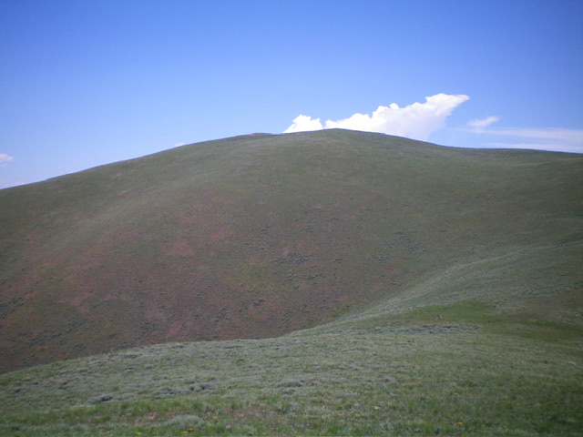
Pattee Benchmark as viewed from Point 6947 high on the southeast ridge (my ascent route). Livingston Douglas Photo
Access
From ID-28 at Tendoy, drive east on [signed] Tendoy Lane for 0.1 miles to a “T” junction. Go right/south here and drive 0.2 miles to a [signed] junction with Agency Creek Road (which goes all the way to Lemhi Pass). Reset your odometer at this junction. At 4.2 miles, pass a BLM campground on the right/southeast side of the road. At 5.1 miles, reach an unsigned junction with a private 2-track road (left).
Park along Agency Creek Road just past this road in a roadside pullout. This pullout sits at the toe of the southeast ridge of Pattee Benchmark. It is at 5,425 feet and 44⁰57’31”N, 113⁰32’43”W. This is the first leg of a 2-peak adventure that includes Pattee Benchmark and Peak 7300. It covers 4.5 miles with 2,375 feet of elevation gain round trip. This route crosses a short section of unposted private land at the toe of the southeast ridge of Pattee Benchmark.
Map Errors
The USGS topo map shows a 4WD road that heads north then west all the way up to a 6,919-foot saddle just south of Pattee Benchmark and northeast of Peak 7300. However, this old road ends only a short distance above Agency Creek Road. The road begins on private land but quickly reaches BLM land. It is the road near which I parked along Agency Creek Road.
Southeast Ridge, Class 2
The Climb
From the roadside pullout, bushwhack north up a sagebrush shoulder on the right/east side of a prominent gully. Scramble up this scrub ridge of thick-ish sagebrush and field grass early on. Cross a maintained cattle fence at about 5,680 feet. This fence is the dividing line between private land to its south and BLM land to its north. The ridge terrain soon becomes a much easier mix of short grass and scrub.
The ridge is steep in spots but has a use trail on-and-off to expedite the climb. Higher up, the terrain becomes mostly short grass and stable gravel/dirt. It is wide open with splendid views. Reach gentle Point 6947 then descend 85 feet to a saddle in short scrub. Continue north then northwest, following a fence row on the left/west side of the ridge, to reach a 2-track road on the summit ridge. Follow the old road west then southwest to the summit of Pattee Benchmark.
The high point of Pattee Benchmark had a torn-down cairn, which I rebuilt. It had no benchmark. The benchmark is on a slightly lower hump to the west (5 feet lower). The official/measured summit has a USGS benchmark, triangulation posts/wiring, and a few triangulation cairns. I stuck a triangulation post in the highest cairn. But, remember, this hump is not quite the high point. The high point of Pattee Benchmark is at about 7,307 feet.
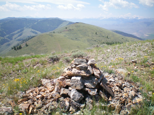
The summit of Pattee Benchmark. Peak 7300 is in mid-ground. Livingston Douglas Photo

The USGS benchmark atop Pattee Benchmark. Livingston Douglas Photo
South Ridge, Class 2
The Descent
From the official summit, descend south-southwest on the remnants of an old 2-track road (which is so poor that I rate it Class 2) to a gentle, wide saddle at 6,919 feet (map). This saddle has a cattle fence, cattle gate, and cows to greet you. This is the connecting saddle between Pattee Benchmark and Peak 7300. It concludes the first leg of today’s 2-peak adventure. Peak 7300 is up next.
Additional Resources
Regions: Beaverhead Range->EASTERN IDAHO
Mountain Range: Beaverhead Range
Longitude: -113.5586 Latitude: 44.9764