Elevation: 10,273 ft
Prominence: 613
This peak is not in the book. Published November 2025
Peak 10273 is a beautiful, rocky peak that sits above the convergence of Kane Creek and Summit Creek in the Pioneer Mountains. It can be climbed either from Phi Kappa Creek Road to its west or from Kane Creek Road to its east. Peak 10273 is a steep, forested, rocky bushwhack from either side and should not be taken lightly. USGS Phi Kappa Mountain
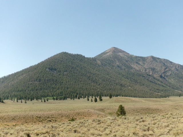
Peak 10273 as viewed from Trail Creek Road to its north. This is a big mountain. Livingston Douglas Photo
Access
Phi Kappa Creek Road/FSR-501 is a rugged 2-track road that is located along Trail Creek Road. The signed road junction is 3.0 miles southwest of [signed] Kane Creek Road and 6.1 miles southwest of [signed] Wildhorse Creek Road. Drive 1.4 miles up this narrow 2-track as it climbs up to the first Phi Kappa Mine. Park here on a spur road to the mine [8,042 feet; 43°50’46.7”N, 114°12’16.4”W].
Map Errors
The drivable portion of Phi Kappa Creek Road ends much sooner than the USGS topo map indicates. There are old mining roads above this point but they are not drivable without an ATV or MC. Contrary to the USGS topo map, there is no road that follows the east side of Phi Kappa Creek after reaching the first of the Phi Kappa Mines.
West Shoulder/North Ridge, Class 3
The Ascent
This route begins on private mining land (according to LOJ) but there is no signage to prohibit parking or hiking here. Unfortunately, reaching the west shoulder from the first Phi Kappa Mine is not feasible due to ugly rock buttresses and very steep terrain in the bottom section of the shoulder. From the nice, flat spur road, walk south for about 20 yards on the main road. Leave the road and scramble left/east up a steep slope of loose scree/gravel. Quickly intersect a diagonal mining road in this open terrain. Follow a few switchbacks on this mining road (or scramble uphill directly for a shorter climb) to reach the crest of a forested rib that sits just south of, and across a dry gully from, the magnificent, more impressive west shoulder.
Scramble briefly east up the forested rib. Leave this rib to cross a small stream in the steep gully. Once across the stream, scramble up the steep, loose south side of the west shoulder to reach the ridge crest. This is the crux of the climb. It is very steep and has lots of loose scree/gravel to torment you. However, it does have some scattered pines, areas of firmer talus, minor rocky outcrops, and occasional ground boulders to provide some footing. Once on the west shoulder, follow it east then east-southeast up to the north ridge.
The west shoulder is persistently steep but has a few flatter areas. The ground rock is mostly scree and gravel but there are some scattered pines to help with footing. There are 2-3 short sections that are particularly steep/loose and require patience. Overall, the west shoulder goes reasonably well. The final push to the north ridge is on solid talus and ridge rock. Once on the north ridge, follow it right/south. This ridge has some minor ups and downs. The terrain is a mix of talus and rocky ridge outcrops. The summit high point is at the south end of this high ridge section and has a decent summit cairn.

The beautiful west shoulder (in mid-ground). This was the bulk of my ascent route. Livingston Douglas Photo

The summit hump of Peak 10273 as viewed from high on the south ridge. This was the first leg of my descent route. Livingston Douglas Photo
South Ridge/West Rib, Class 3
The Descent
From the summit, descend southwest on the easy, open ridge crest to reach the top of the west rib. The west rib sits across from, and to the south of, the west shoulder. It is pretty obvious and is not difficult to find. The west rib is steep, loose scree/gravel up high but soon becomes more forested. The forested terrain is a bit more stable but ridge trees and blowdown present some challenges in the descent. Farther down, the rib descends into the gully that separates the west rib from the west shoulder. Descend the left side of the rocky rib and cross a minor gully to avoid dropping into the large gully.
From the minor gully, follow a game trail up onto the crest of the lower section of the west rib. This rib leads directly northwest down to the Phi Kappa Mines and the open scrub face just left/west of this forested rib. Work down through some face rock and ledges to reach the old mines and diagonal mining roads. Descend directly down through easy sagebrush, crossing mining roads as you go, to reach the main road and the spur road at the first Phi Kappa mine. Overall, the west shoulder is a better ascent/descent route than the west rib. However, it takes more work to get over and up onto the west shoulder. It takes almost no work to get up onto the west rib.
Additional Resources
Regions: EASTERN IDAHO->Pioneer Mountains
Mountain Range: Pioneer Mountains
First Ascent Information:
- Other First Ascent: South Ridge/West Rib—Descent
- Year: 2025
- Season: Summer
- Party: Livingston Douglas
- Other First Ascent: West Shoulder/North Ridge
- Year: 2025
- Season: Summer
- Party: Livingston Douglas
Longitude: -114.1905 Latitude: 43.8427