Elevation: 10,734 ft
Prominence: 315
This peak is not in the book. Elevation and prominence figures are based on LiDAR measurements. Dave Pahlas suggested the name for this peak based on its proximity to the defunct Livingston Mine. Published February 2024
Peak 10734 is a newly-ranked summit (thanks to LiDAR). It is one of two ranked summits that sit above the headwaters of both Jim Creek and Gunsight Creek. Railroad Peak (10,848 feet) is its sister peak to the west. The view of Gunsight Lake, Dike Lake, Tincup Lake, and Quartzite Lake is splendid from both of these peaks. USGS Livingston Creek
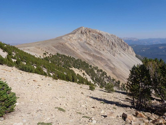
Peak 10734. Dave Pahlas suggests the name Livingston Point for this peak. Dave Pahlas Photo
Access
Big Boulder Creek Road/FSR-667 and the large parking area for the East Side Trail/FST-047 and the Big Boulder Creek Trail/FST-680 (see (B)(2)(a) and (B)(2)(a.1) on Page 230 of the book). From the parking area, either hike (or drive) west on FSR-667 for 0.2 miles to a signed road junction (no parking available at this junction). Hike (or drive) right (north then west) on Jim Creek Road/FSR-669. Jim Creek Road is a rocky, narrow jeep road that requires a 4WD vehicle with good tires.
Peak 10734 is most easily climbed in combination with nearby Railroad Peak via its west ridge from the 10,420-foot connecting saddle. Please refer to the Railroad Peak page for more information on this route.
West Ridge, Class 2
The Climb
From the 10,420-foot connecting saddle with Railroad Peak (10,848 feet), scramble east then southeast up talus/scree and tundra. Stay left/north of the ridge crest as the ridge narrows and becomes much rockier. Skirt the north side of the crest until just below the high point. Head south to the narrow, ridge crest summit. As with nearby Railroad Peak, the summit offers splendid views of the headwaters of both Jim Creek and Gunsight Creek. If climbing Peak 10734 independently of Railroad Peak, ascend the Northeast Gully Route on Railroad Peak (see the Railroad Peak page) to reach the 10,420-foot connecting saddle.
North Ridge, Class 2
The Climb
From the trailhead parking area, hike west up Big Boulder Creek Road for 0.2 miles to a signed road junction. Head right/north onto Jim Creek Road/FSR-669. This road soon bends hard left/west and follows the north side of Jim Creek. After hiking up Jim Creek Road for about 3.5 miles, reach a 3-way road junction (9,278 feet on map). To the left/south is a gated road that is private and leads to the Livingston Mine area. Straight ahead is a gated road (publicly accessible but not shown on maps) that continues up the Jim Creek drainage. Head straight up this old 2-track road until it ends northwest of the Livingston Mine buildings to the southeast.
Bushwhack across the east side of a marsh to reach the toe of the rounded north ridge. Scramble up a mix of talus/scree and tundra on the right/west side of the ridge crest. The left/east side of the ridge crest has wicked exposure so avoid it. At about 10,200 feet, the slope eases and becomes more of a face climb. The summit is on a narrow ridgeline and offers splendid views of both the Gunsight Creek drainage and the Jim Creek drainage.
Additional Resources
Regions: EASTERN IDAHO->White Cloud Mountains
Mountain Range: White Cloud Mountains
Longitude: -114.58658 Latitude: 44.12724