Elevation: 5,821 ft
Prominence: 316
This peak is not in the book. Published November 2022
Peak 5821 is a hump that is sandwiched between North Junipers HP and South Junipers HP. This area is a mix of private and public land, so be careful. This hike can be done entirely on BLM land. Peak 5821 can be climbed either solo or in combination with North Junipers HP or Peak 5961. It is most easily reached from Grassy Ridge Road to the north. This route avoids the dubious sandy roads that could you leave you stranded in deep sand. USGS Big Grassy Ridge
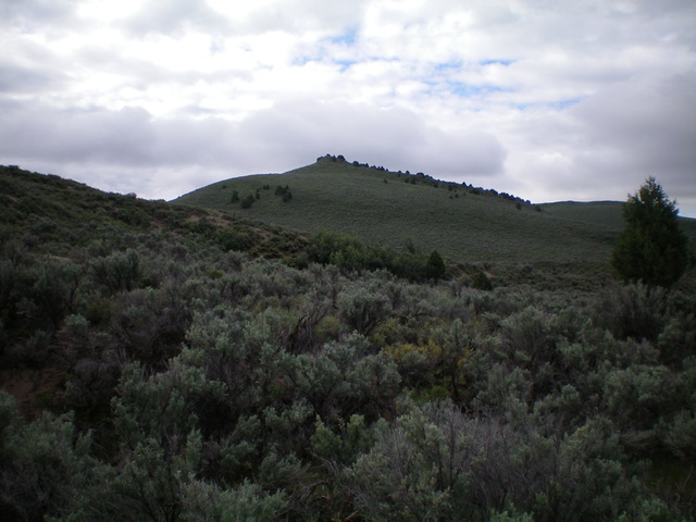
Peak 5821 as viewed from the north. Livingston Douglas Photo
Access
Grassy Ridge Road (unsigned) is reached from Red Road. Red Road is a north-south paved road that is located west of Parker, Idaho. It can be reached from Parker via West 4th North Road or via South Parker Road (500N). Follow either road west to its junction with [signed] Red Road, which is signed as 1900E. From the south, Red Road can be reached on US-20 in North Rexburg (Exit 337). After exiting US-20, turn left/north onto [unsigned] Salem Road (which becomes Red Road). Drive 6.1 miles north on Salem/Red Road to its signed junction with 500N.
From the signed junction of 500N and 1900E (Red Road), drive north on Red Road (a paved, 50MPH road) for 8.2 miles to an unsigned junction with Grassy Ridge Road (a wide, well-maintained gravel/red dirt road). Ironically, Red Road is not red at all. It is a paved, blacktop highway. Grassy Ridge Road is a road of red gravel/dirt. Grassy Ridge Road is the true “red road.” Reset your odometer at the junction of Grassy Ridge Road and Red Road.
At 4.2 miles, reach an unsigned road junction at 4.2 miles with a southbound jeep road with a “Camping Regulations” sign near its base. Park at this junction (5,413 feet on the map) or drive a short distance south on the rutted dirt road (which may be impassable due to mud holes and ruts) a short distance to an open camping area and park there. This route uses ATV trails to some extent. However, many of the ATV trails in this area are NOT shown on the USGS topo map.
North Face, Class 2
The Climb
From the road junction on Grassy Ridge Road, follow the weak 2-track ATV trail (shown on maps) south then southwest as it skirts the right/west side of a series of sand dunes. Once past the sand dunes, leave the ATV trail and bushwhack south through sagebrush gullies and ridges to intercept another ATV trail (not shown on maps) that heads southwest along the base of the northwest side of North Junipers HP. This ATV trail crosses the west ridge of North Junipers HP just east of Point 5667.Continue on the ATV trail as it descends south to intercept an east-west ATV trail (shown on maps) that crosses the broad sagebrush valley that separates North Junipers HP from South Junipers HP.
From the unsigned road junction, follow the ATV trail left/southeast for about a mile to get just past a series of sand dunes on the right/south side of the trail. Leave the ATV trail and bushwhack south on the east side of the large sand dunes through thick sagebrush. Skirt the right/west side of Point 5592 and cross a dry gully to reach the base of the north face of [obvious] Peak 5821. Scramble south up the sandy, sagebrush-covered face to reach the summit boulders and the top of Peak 5821. This section crosses a short section of private land but there is no fencing or signage to prohibit entry. To avoid any private land, you can scramble up the northwest face to intersect the west ridge and follow it to the rocky summit. The summit has no summit cairn.

The summit boulders atop Peak 5821. Livingston Douglas Photo
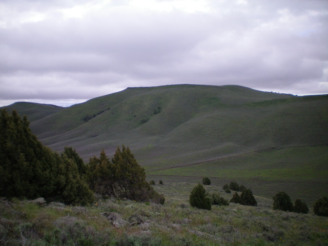
South Junipers HP as viewed from the summit of Peak 5821. Livingston Douglas Photo
Additional Resources