Elevation: 6,025 ft
Prominence: 365
This peak is not in the book. Published December 2019
Peak 6025 is a ranked summit located just southeast of Bradley Summit at the south end of the Pioneer Mountains. Its southwest ridge is simply magnificent and drops over 1,000 vertical feet to the valley floor. There is a lot of private land in this area so be careful. Consult the BLM Fairfield map to see the property lines. USGS Picabo
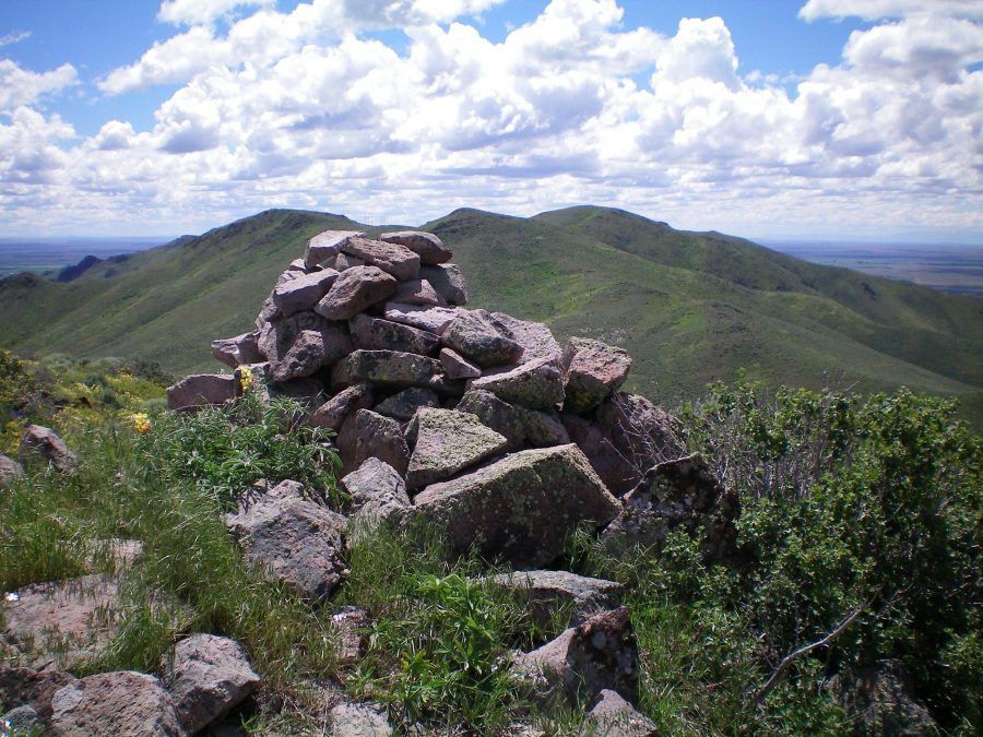
The summit cairn atop Peak 6025 looking south. Peak 6145 is the most distant hump right of center. The ridge traverse to get there is a tedious endeavor with lots of weaving and ups/downs. Livingston Douglas Photo
Northwest Ridge, Class 2
Access
From the Texaco station on US-20 in downtown Picabo, go north on signed North Picabo Road. This road junction is 10.9 miles east of ID-75 on US-20. Drive 2.1 miles north on North Picabo Road to a BLM-signed road on the right/northeast side. This road junction is soon after North Picabo Road bends left/west at the base of the mountains. Drive 0.2 miles up this 2-track BLM road to a large parking area on the right side of the road in an open field.
The road gets rougher and more rutted from here. Have some respect for your vehicle. The elevation at the parking area is 4,950 feet. The 2-track BLM road goes northeast all the way to Bradley Summit and makes for good hiking. In 15 minutes or so, you’ll be standing on Bradley Summit. The USGS topo map incorrectly places the BLM road’s beginning farther down North Picabo Road. There IS a very rough road there but it doesn’t go very far. Avoid it.
The Climb
From the parking area, hike up the steep, rocky, rutted BLM road to Bradley Summit which, of course, is actually a PASS. From Bradley Summit, follow a cattle fence southeast as it follows the ridgeline. This fence row follows, or is close to, the ridge crest most of the way to the summit of Peak 6025. The fence row is good in some areas and dilapidated in others. In addition, there are some very large/tall power lines that are close to, or on, the ridge.
The terrain on the ridge is tedious and is a combination of thick sagebrush, talus, and rocky outcrops/points. The fence row and power lines will help mitigate some of the time-consuming off-trail scrambling up here. Use those man-made constructs to your advantage to expedite your ascent. The summit of Peak 6025 is a sagebrush hump with some loose talus scattered about. It has a large summit cairn and a great view of the connecting ridge with Peak 6145 to the south.
Southeast Ridge, Class 2
Access
Same as for the northwest ridge. This is the first leg in a ridge traverse from Peak 6025 to Peak 6145.
The Descent
From the summit of Peak 6025, follow the ridge crest southeast as it weaves around, has a few ups and downs, and forces you to work your way through some tedious terrain at times. The southeast ridge ends at a wide saddle (5,660 feet) just south of Point 5735.
If you complete the entire ridge traverse from Peak 6025 to Peak 6145, there is a whopping 900 feet of uphill in going from Peak 6025 to Peak 6145, yet only 120 vertical feet of net elevation gain. On the way back from Peak 6145, the ridge demands another 700 feet of uphill to DROP a net of 120 vertical feet. That in itself is tiresome. Be prepared for it.
Southwest Ridge, Class 2
Access
Same as for the northwest ridge. This is the final leg of a loop route that begins and ends near the base of a BLM road that leads up to Bradley Summit.
The Descent
After returning to the summit of Peak 6025, let’s descend the magnificent southwest ridge. It leads right down to North Picabo Road. As you approach the road, however, you must bend right/west at 5,400 feet to avoid the private land at the toe of the southwest ridge proper. The southwest ridge has less sagebrush and more rock/talus and open grass than the northwest ridge or the connecting ridge between Peak 6025 and Peak 6145.
There is an on-and-off cattle fence on this ridge, though it’s not as prevalent as on the primary northwest-to-southeast ridge crest high above. Once you reach North Picabo Road, walk north then northwest up the road to its junction with the BLM road. Hike 0.2 miles up the BLM road to the parking area and your awaiting vehicle.
Additional Resources
Regions: EASTERN IDAHO->Pioneer Mountains
Mountain Range: Pioneer Mountains
Longitude: -114.05239 Latitude: 43.33959