Elevation: 6,450 ft
Prominence: 360

This peak is not in the book. This peak is in an area identified as the Fish Creek Range. It is a small subrange of the Portneuf Range. Published November 2023
Peak 6450 is a scrub hump that is located at the south end of the Fish Creek Range in eastern Idaho. To remain entirely on BLM land, it is best climbed in combination with Peak 6536 from Beaver Dam Road. This area is a mix of private and public land, so be careful.This climb is entirely on BLM land. USGS Grace Power Plant
Peak 6450 as viewed from the north. Livingston Douglas Photo
Access
Same as for Peak 6536. This is the second leg of a 2-peak adventure that includes Peak 6536 and Peak 6450. It covers 4.5 miles with 1,500 feet of elevation gain round trip.
North Gully/North Ridge, Class 2
The Climb
From the east-west gully that separates Peak 6536 from Peak 6450, scramble south up the [obvious] north gully of Peak 6450, staying right/west of a rocky ridge point (Point 6200+). Either follow a cattle trail (which turns into an old 2-track) on the right/west side of, then center of, the gully (as I did on my descent) or scramble up the left/east side of the gully on angled grass/scrub (not difficult) in open terrain. Once at the top of the dry gully, head left/east briefly to reach a minor saddle at the base of the north ridge of Peak 6450.
From the saddle, follow a weak foot trail up the rounded north ridge (which feels more like a face) in thick grass/scrub. Avoid the dense aspens and forest on the right/west side of the ridge. The foot trail turns into the remnants of an old 2-track (not shown on maps) about midway up the ridge. This overgrown 2-track leads all the way to the summit. The high point is at the west end of the brushy summit plateau. It has a large, flattened cairn and offers beautiful, unobstructed views of the surrounding area.
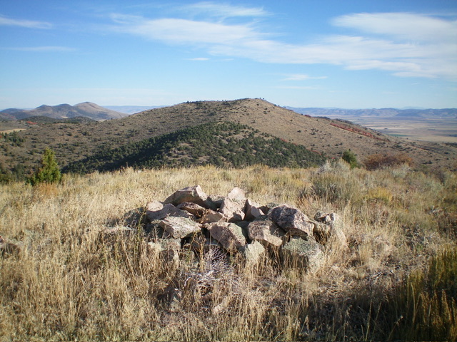
The summit cairn atop Peak 6450 with Peak 6536 in the distance. Livingston Douglas Photo
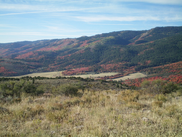
Summit view from atop Peak 6450. Livingston Douglas Photo
Descent Back to Beaver Dam Road, Class 2
From the summit, return back to the ridge saddle. Find the remnants of an old 2-track road (not shown on maps) that heads down the center of the north gully. The 2-track soon becomes a cattle trail and moves to the west side of the gully. It quickly gets you back down to the large east-west gully that separates Peak 6450 from Peak 6536. Cross the 2-track road in the east-west gully and follow a weaker 2-track that heads north up a gully on the southwest side of Peak 6536. This 2-track reaches a shoulder on the west side of Peak 6536 then turns right/northeast to climb to the summit.
You have two choices here. Either follow the 2-track road to the summit of Peak 6536 and then descend the North Ridge/Northwest Face Route OR leave the 2-track road and bushwhack north down to a fence row alongside irrigated land to the left/west and scramble north through sagebrush to intercept the 2-track road that leads back to Beaver Dam Road. I chose the latter option for my descent. However, given the thick sagebrush (and some aspen patches) involved with the latter route, I recommend re-climbing Peak 6536 and descending its ascent route.
Additional Resources
Regions: Fish Creek Range->Portneuf Range->SOUTHERN IDAHO
Mountain Range: Portneuf Range
Longitude: -111.8514 Latitude: 42.5147