Elevation: 6,537 ft
Prominence: 317
This peak is not in the book.
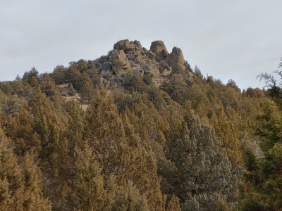
Peak 6537 is one of the more rugged Owyhee summits located in the Indian Meadows area east of South Mountain. USGS Indian Meadows
Peak 6537. Brett Sergenian Photo
Access
To access Peak 6537, turn east from Mud Flat Road as if you were going to South Mountain. Pass the turnoff for South Mountain and follow the signs toward Indian Meadows. Drive through a creek crossing and continue driving south and east until you come across a road on your left less than a half mile from the North Fork of the Owyhee Wilderness sign. Turn left and follow the road north for close to three miles, going just west of Peak 6860 before dropping down to 6,200 feet. The road seemed like it was in decent shape but I jogged it.
Route
Descend to Indian Creek at roughly 5,900 feet and hike northeast towards the middle summit, which is the high point. You will pass a road on your way but that road was posted several miles to the south. Reach the summit block just north of the summit through thick brush. There are numerous rock towers that are close in height, but the highest one just involves a short Class 3 move on its north side. One of the rock towers just to the south looked like it was Class 5 but was slightly lower. Return the way you came.
Additional Resources
Regions: Owyhee Mountains->SOUTHERN IDAHO
Mountain Range: Owyhee Mountains
Longitude: -116.7903 Latitude: 42.7396