Elevation: 6,603 ft
Prominence: 343
This peak is not in the book. Published January 2023
Peak 6603 is a minor scrub hump that is located between Glen Canyon and Crazy Canyon in the southern Subletts. The desert roads in this area are of dubious quality and can be impossible to drive when wet. This area is a mix of private and public land, so be careful. This climb is entirely on BLM land. USGS Juniper
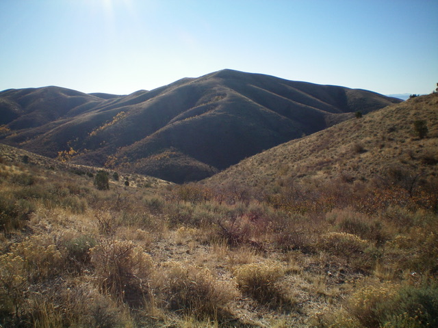
Peak 6603 (dead center) as viewed from the northwest. The northwest ridge (my ascent route) is in dead center and is coming at the camera. Livingston Douglas Photo
Access
Peak 6603 is located along Glen Canyon Road. Glen Canyon Road is blocked by private land in the south. However, the road is accessible from the north via a junction with Meadowbrook Road. Whether or not road conditions are amenable is another story. Meadowbrook Road was in pretty rough shape when I drove up it in 2022. I chose to climb the peak from Meadowbrook Road and climb up over an intermediate ridge to then drop into Glen Canyon to reach Peak 6603.
From Exit 254/Sweetzer Road on I-84, drive south on the frontage road on the east side of the freeway. At 2.3 miles, reach an unsigned junction with Meadowbrook Road. Reset your odometer at this junction. At 3.0 miles, reach BLM land. At 5.8 miles, reach an unsigned junction with a 2-track road that goes up a dry gulch. Turn right/east onto this 2-track and drive 100 yards to a pullout area and park (5,620 feet). GPS coordinates: 42⁰14’13”N, 112⁰57’28”W.
Depending upon road conditions, you may be able to drive another 0.2 miles up the narrow 2-track to a meadow where the road turns right/south. Beyond that point, the 2-track is overgrown and badly rutted. It would be very difficult to drive and has no place to turn around. Please be advised that Meadowbrook Road is in rough shape. It is badly rutted with inches of deep dirt. When dry, it is extraordinarily dusty. When wet, this road will be impossible to drive. According to maps, this is one of the better roads in this desert area. That tells you something about how road conditions can change.
Northwest Ridge, Class 2
The Climb
From the parking area, hike east up the 2-track for 0.2 miles to a cistern in an open meadow. The road bends sharply right/south. The USGS topo map shows a road junction here but there is no such junction. Hike south on the deteriorating 2-track for another 0.3 miles to a junction in a meadow (shown on the USGS topo map). Continue straight south on a very weak 2-track (that soon becomes a cattle trail) for another 0.2 miles in a sagebrush-clogged dry gulch to reach a prominent side gully that heads left/southeast.
Leave the main gulch here and follow an old cattle trail in the center of the gully. This trail is badly overgrown with sagebrush and is now a narrow, hard streambed for rain runoffs. Continue to bushwhack southeast in this gully (ignoring another gully heading left/east higher up) all the way to a ridge saddle with a cattle gate and dilapidated cattle fence. You can see this cattle gate from midway up the dry gully. From this ridge crossing, you have a magnificent view of Glen Canyon and Peak 6603 to the southeast. Its magnificent northwest ridge is inviting.
From the cattle gate, descend southeast down a dry gully, using a cattle trail in its center to assist in getting through the unending sagebrush. The trail is old and overgrown but it is still useful. Descend about 460 vertical feet to reach, and cross, Glen Canyon Road. Bushwhack left-ish/east up onto the northwest ridge through some thick-ish sagebrush and other brush. Reach the rounded ridge crest and follow it as it wiggles right/south then left/east, generally going in a southeasterly direction. The ridge scrub is reasonable. Higher up, the ridge terrain is short scrub/grass and it is a cruise to reach the gentle summit hump of Peak 6603. The summit had a small, torn-down cairn so I rebuilt it and enhanced its size.
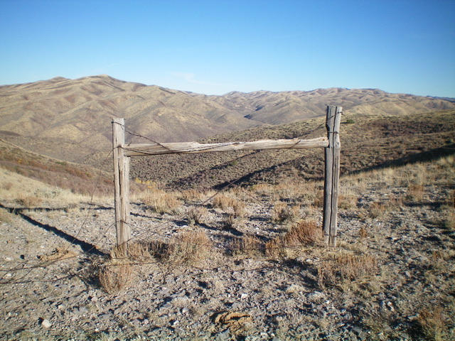
The critical fence “gate” on the saddle at the crossing of the intermediate ridge to drop to Glen Canyon. This is a crucial navigational spot for the climb of Peak 6603. This view is looking west, not east toward the summit. Livingston Douglas Photo
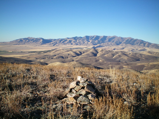
The summit of Peak 6603 with the Black Pine Mountains in the distance. Livingston Douglas Photo
Additional Resources
Regions: SOUTHERN IDAHO->Sublett Range
Mountain Range: Sublett Range
Longitude: -112.93469 Latitude: 42.2125