Elevation: 6,850 ft
Prominence: 960
This peak is not in the book. Published November 2022
Peak 6850 is a seldom-climbed peak that is located up a side drainage on the west side of Cow Creek in the Soldier Mountains. This is the first leg of a 2-peak adventure that includes Peak 6850 and Camas Benchmark (6,680 feet). USGS High Prairie
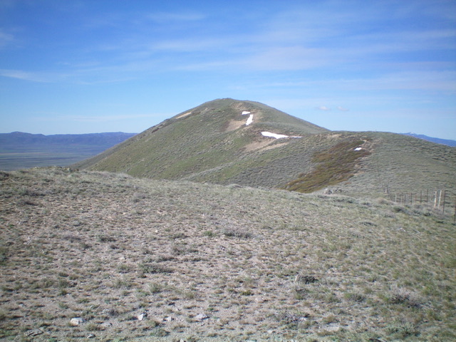
Peak 6850 as viewed from high on the northeast ridge. Livingston Douglas Photo
Access
From US-20 at the east end of Hill City, turn north onto [signed] 1300W. Drive 2.7 miles north on 1300W to a signed “T” junction with Harrison Road. Turn left/west onto Harrison Road and drive 2.1 miles to an unsigned junction with Cow Creek Road. Turn right/northwest onto Cow Creek Road and reset your odometer. At 2.6 miles, reach the Sawtooth National Forest boundary. At 2.8 miles, reach a forested campsite and a sharp right bend in the road. Park/camp here (5,729 feet). GPS coordinates: 43⁰22’22”N, 115⁰07’19”W.
East Face, Class 2
The Climb
From the campsite along Cow Creek Road, bushwhack south up onto the northeast ridge of Point 6429. The easiest way to reach the ridge crest is to follow an old road (which quickly becomes a cattle/game trail) west up the forested drainage a short distance then scramble up steep sagebrush to the ridge crest. Once on the ridge crest, follow the easy, open ridge through short, gapped sagebrush up to Point 6429. From Point 6429, descend west-northwest to a saddle, dropping 135 vertical feet in the process.
From the saddle, follow a dilapidated fence row west then northwest. Leave the fence row as it heads to Point 6669 and angle left/west across a gully. Once across the gully, climb through steep, tall sagebrush up the east face directly to the rocky summit of Peak 6850. There are two cairns on top. The northern cairn/point is the high point of Peak 6850. The southern cairn/point is about five feet lower.
West Face, Class 2
The Descent (then Ascent)
From the summit, descend west-southwest down a ridge of sorts on steep talus (with sagebrush mixed in) to reach a fence corner lower down. Follow the fence row southwest down the ridge briefly to reach flatter ground (all sagebrush). Look for a grassy, elongated meadow with a patch of aspens at its far end. This meadow is in a drainage that sits at the base of the west face of Peak 6850 and it is obvious. Leave the ridge fence and descend directly west into the sagebrush drainage then into a beautiful meadow of short grass. Follow the meadow northwest to a patch of aspens and a junction of two drainages. This concludes the first leg of today’s 2-peak adventure. Camas Benchmark is up next.
Northeast Ridge/East Shoulder, Class 2
The Descent
Return from Camas Benchmark and climb the west face to the summit of Peak 6850. From the summit, descend the easy, open northeast ridge (with several ups and downs) to a large cairn at Point 6620+. This ridge point is the top of the east shoulder, which leads directly down to Cow Creek Road and the campsite from which today’s journey began. Descend the somewhat-tedious sagebrush on this shoulder east-southeast (with an obvious drainage just to its left/north) down to the forested drainage. The shoulder does a final bend left/north lower down. Drop off the shoulder into the open pine forest and follow the easy terrain east on a game trail to reach the remnants of an old road and quickly reach Cow Creek Road a short distance up from the campsite where you are parked.
Additional Resources
Regions: Soldier Mountains->WESTERN IDAHO
Mountain Range: Soldier Mountains
Longitude: -125.14369 Latitude: 43.36829