Elevation: 6,852 ft
Prominence: 527

This peak is not in the book. The name Hangman Peak is in use locally. Margo Mandella provides beta on the southwest ridge route. Livingston Douglas offers details on three other routes on this peak. Updated December 2019
Hangman Peak by Margo Mandella
Hangman Peak is located just northeast of Hailey, Idaho. It sits above a popular local hiking area. This peak is also known as Red Devil East. Red Devil Mountain, just to the west, is easily identifiable by the red rock on its west face. However, Red Devil Mountain is not a ranked peak. Hangman Peak sees a lot of wildlife and there are game trails crisscrossing its west face. The southwest ridge, which crosses the top of Point 6660, is the most frequently climbed route to Hangman Peak. USGS Hailey
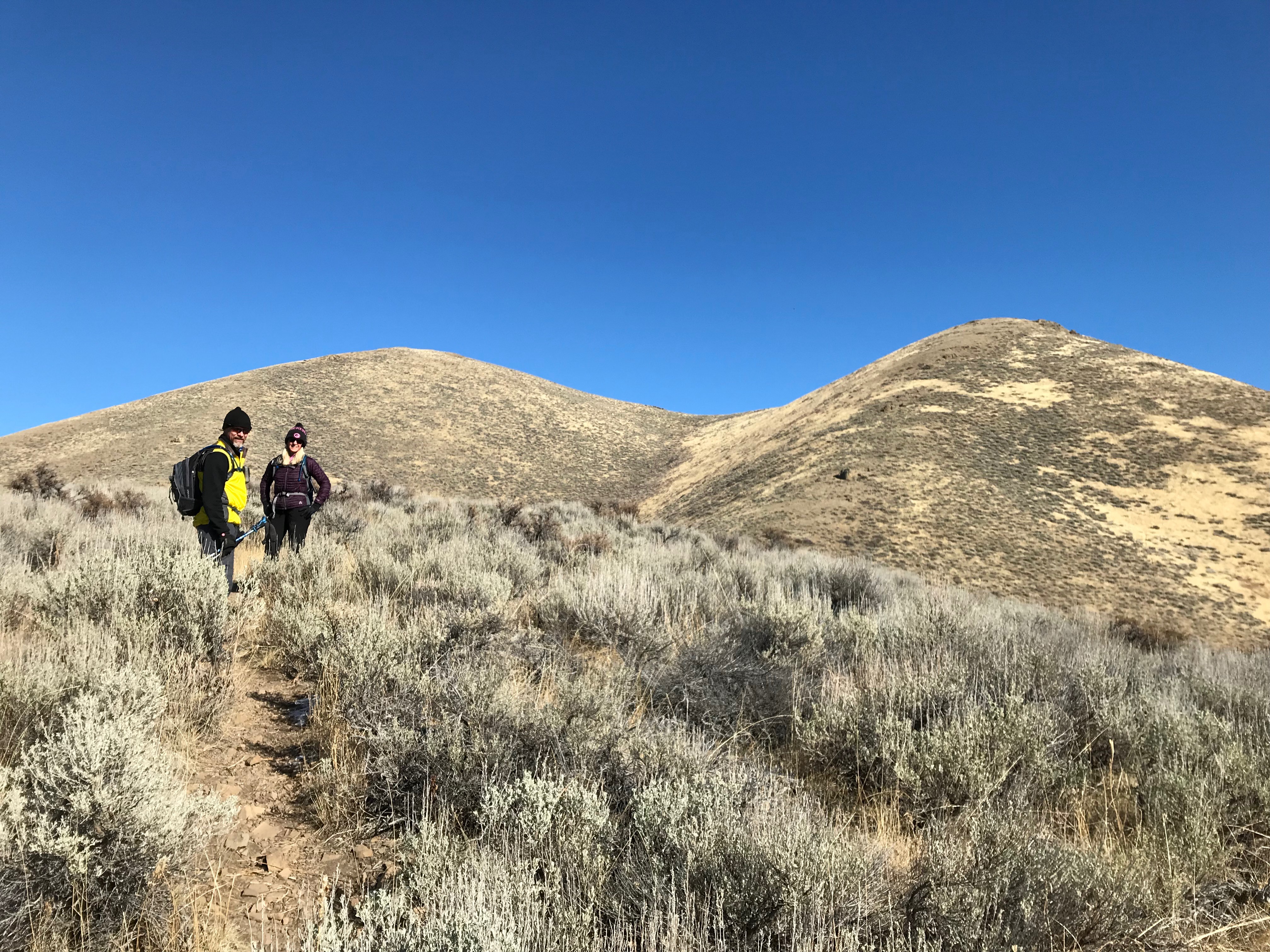
Peak 6852 (left) and Point 6660 (right). Margo Mandella Photo
Access
Traveling north to Hailey on ID-75, continue into downtown Hailey on Main Street until you reach Croy Street. Turn right/northeast and continue northeast until Croy turns to the southeast. At this corner, begin looking for Quigley Drive to your left/northeast. Turn onto Quigley Drive and take it to the end of the pavement where you’ll find a parking area on the left and a trailhead sign.
Southwest Ridge, Class 1+/2-
The climb to Hangman Peak begins at this trailhead. As the GPS track shows, we climbed to the summit of Point 6100 and followed the path east to the base of Point 6660. We ascended over Point 6660 and continued on the trail over the upper saddle to the summit of Hangman Peak.
On the way down, we backtracked the trail and, once we reached the lower saddle, we branched onto a gully trail, eventually connecting to the main traverse trail back to the trailhead. Coming down this way, we briefly skied a little scree off the main trail taking a shorter, sportier way to the traverse trail. However, if we hadn’t turned as soon, we would have connected to the main traverse trail and missed the scree entirely. But on the traverse trail, there is a slab rock section that you will need to negotiate, but it’s easy enough to do. Minor obstacles either way keeps things interesting.
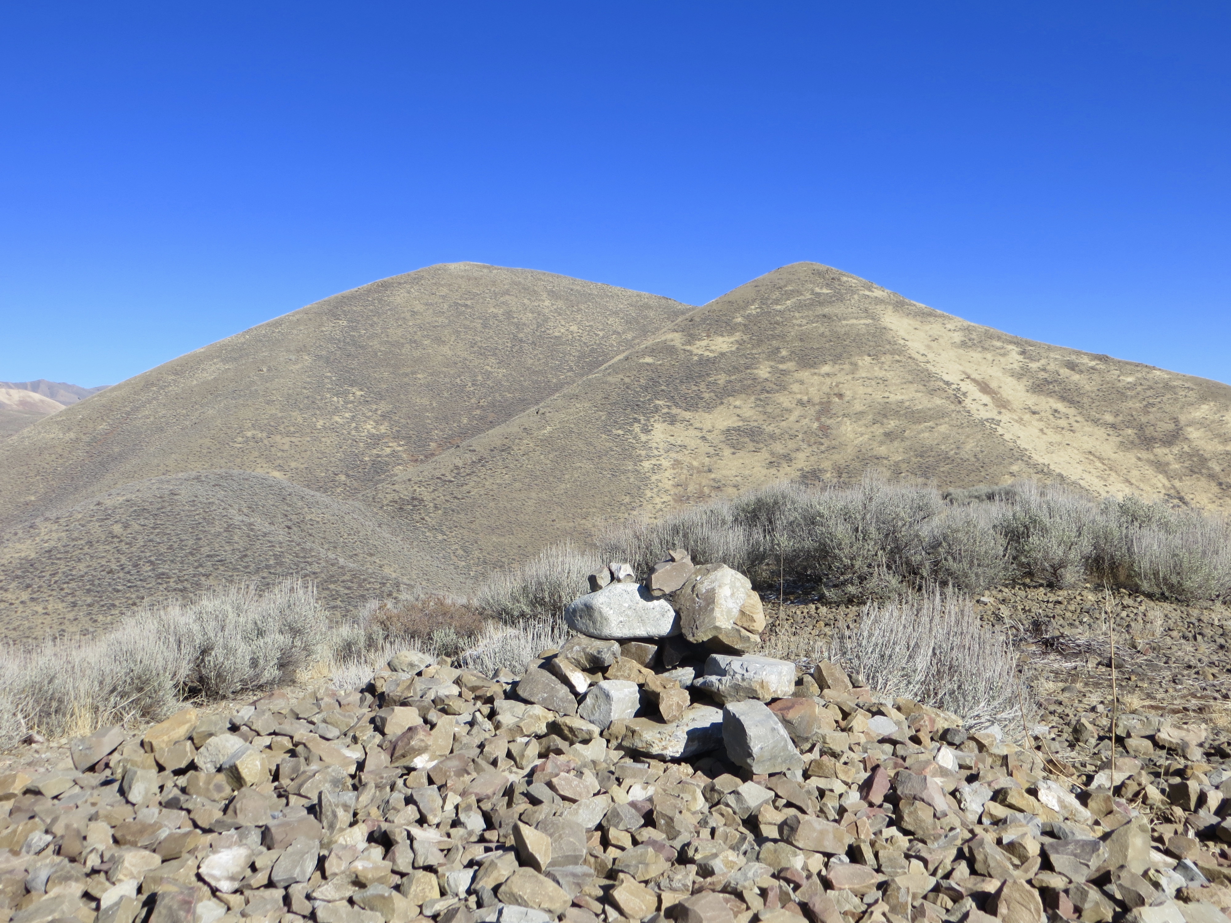
The summit cairn atop Hangman Peak. Peak 8120 (left) and Peak 8189 are in the background. Steve Mandella Photo
Several hiking/spur trails intersperse with game trails and braid around the lower elevations of the peak. There’s no doubt a more direct ascent and various climbing combination(s) you can use via the southwest approach. Our path takes you right up the steep ridge and keeps you high on the ridge to enjoy great views the entire way. However you choose to approach the summit via the southwest, you can stay on a trail for the entire climb.
The most challenging part of the climb is from the saddle after Point 6100 to the summit of Point 6660. This 600-foot west-facing section is dry, steep, and the surface can be loose with rocks/pebbles on hardpack. Even with a trail to the top, the grade of this section might pose a challenge for some folk, thus the in-between rating. In general, I consider this a “sport hike” for most peakbaggers, challenging enough for a workout and a great early-season conditioner. Trip stats: 3.41 miles with 1,437 feet of elevation gain round trip.
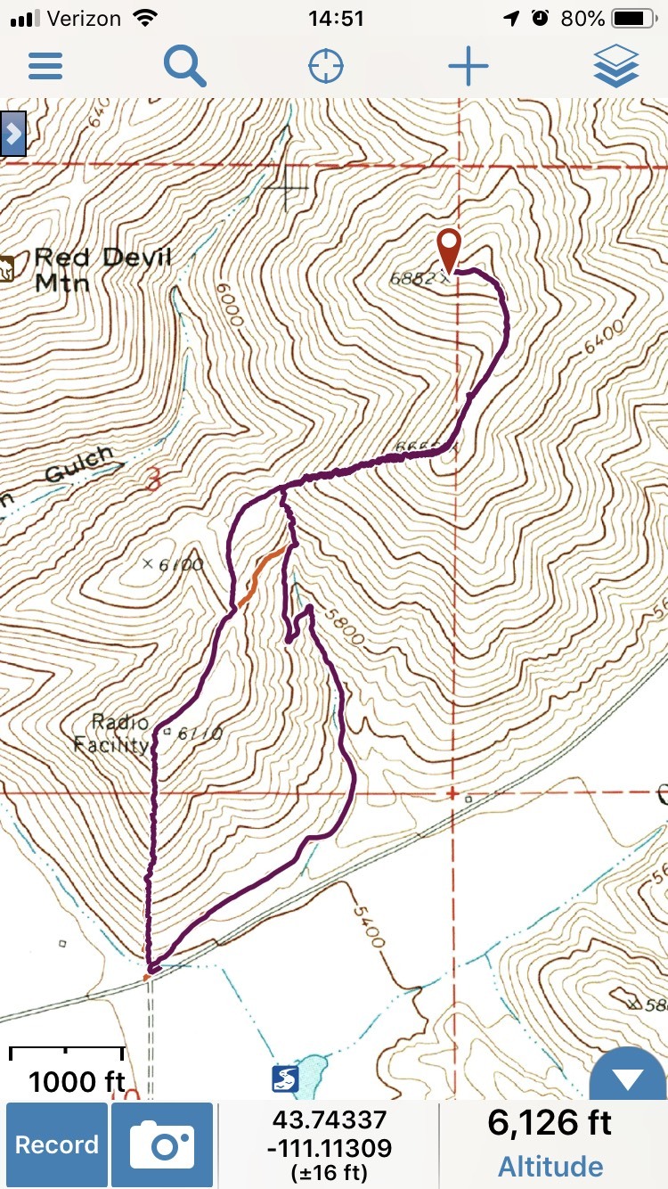
Track for the southwest ridge of Hangman Peak. The orange leg connects to the gully trail. Margo Mandella track
East Gully/Southwest Ridge, Class 2 by Livingston Douglas
Access
Bullion Street is in the center of Hailey, ID on ID-75. It is signed and has a stoplight at its junction with ID-75. Turn right/east onto Bullion Street. After driving a few blocks, the street bends right/south. Continue two blocks south to [signed] Quigley Road. Turn left/east onto Quigley Road and drive 0.4 miles to a large, unsigned “trailhead” parking area on the left/north side of the road, just past the end of the residential homes on Quigley Road.
Two trails leave from this trailhead. Neither is an official BLM or Forest Service trail. Both trails go through private land, SO STAY ON THE TRAIL. There is a large poster board to remind you. The Quigley Loop Trail (signed and diagrammed at its trailhead) follows the north side of Quigley Road and goes all the way to Quigley Pond. The other trail has no signage; it’s just there. It goes straight up a steep hillside and switchbacks its way north to Point 6110.
Neither of these trails is shown on the Sawtooth National Forest map. However, the “Point 6110 Trail” is shown on the BLM Sun Valley map and part of the Quigley Loop Trail is shown on the same map (only as far as it goes to the base of a large gully, well before the trail ends at Quigley Pond). Both maps are, unfortunately, inaccurate. The scale of the BLM map is such that you can barely even see the trails on it.
The Climb
From the large “trailhead” parking area, walk to the right/east end of the parking lot and follow the [signed] Quigley Loop Trail northeast along the left/north side of Quigley Road for about ½ mile until you reach an unsigned trail junction in the mouth of a wide gully. The Quigley Loop Trail continues straight along Quigley Road. Go left/northwest here and follow an unofficial trail that heads up the center of the gully (let’s call it the “Gully Trail”).
The Quigley Loop Trail is quite docile, well-beaten, and flat. The “Gully Trail” is a different animal. It is steep, narrow, and has a lot of loose gravel. High up in the gulch, the trail forks. You can go straight/north up a steep trail to the ridge saddle or go left/west on a more gradual trail that leads up to the ridge at a ridge saddle east-southeast of Point 6100. If you choose the “gradual trail,” you must subsequently scramble north then northeast on yet another unofficial footpath to reach the saddle at the head of the infamous “wide gully.”
This saddle sits at the base of the west ridge of Point 6660. It is a steep climb up a weak footpath on ball-bearing gravel (very loose) to reach Point 6660. From there, drop to a minor saddle and continue with a bushwhack through thick sagebrush (the footpath disappears) north then west to reach the summit of Hangman Peak.
North Ridge, Class 2
Access
Same as for the east gully/southwest ridge. This route is the first leg of a ridge traverse from Hangman Peak to Red Devil Mountain.
The Descent
From the summit, follow the ridge northeast then northwest over Point 6622 and down to a saddle at 6,340 feet. This saddle is the low point between Hangman Peak and Red Devil Mountain and concludes this leg of today’s 2-peak journey. There are no trails on this route and the sagebrush is rather thick and tedious. The underlying loose scree makes the descent a bit bothersome.
Hangman Shoulder/Southwest Ridge, Class 2
Access
Same as for the east gully/southwest ridge. This route part of the traverse between Red Devil Mountain and Hangman Peak and the return to the trailhead along Quigley Road.
The Climb
The 5,660-foot level in Hangman Gulch is at the base of a shoulder that climbs southeast to reach the southwest ridge of Hangman Peak. There is a side gully heading east here, on the north side of the shoulder. Bushwhack southeast up the somewhat-thick sagebrush on the shoulder for almost 500 vertical feet to reach a gentle ridge point (6,120+) on the southwest ridge of Hangman Peak. From here, follow the southwest ridge to the summit or descend back to Quigley Road.
Additional Resources
Regions: EASTERN IDAHO->Pioneer Mountains
Mountain Range: Pioneer Mountains
Longitude: -114.28739 Latitude: 43.53939