Elevation: 6,864 ft
Prominence: 157
This peak is not in the book. Updated February 2026
Peak 6864 separates Heglar Canyon from Houtz Canyon in the Sublett Mountains. It also sits at the head of Dairy Canyon. Peak 6864 is most easily climbed from a 2-track road to its east from a high saddle. Based on recent LiDAR updates, Peak 6864 is now an unranked summit. USGS North Heglar Canyon
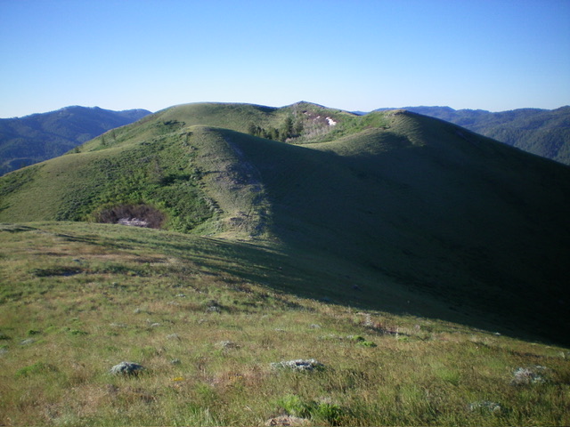
Peak 6864 as viewed from the north. The meandering north ridge leads to the cairned high point in dead center. The official/measured high point is the gentle hump just left of the cairned high point. Livingston Douglas Photo
Access
From ID-37 in Rockland, reset your odometer and drive west on [signed] Center Street (which soon becomes Houtz Canyon Road). At 2.9 miles, reach a signed junction with Miller Road (right). Continue straight on Houtz Canyon Road. At 5.6 miles, reach a signed junction with Dairy Canyon Road (right). Continue straight on Houtz Canyon Road. At 5.7 miles, reach the BLM boundary. Houtz Canyon Road now becomes [signed] BLM-660. At 8.8 miles, reach an unsigned road junction. Park in the grass just past this junction (5,545 feet and 42⁰30’15”N, 113⁰00’15”W).
East Ridge, Class 2
The Climb
From the road junction, follow a narrow 2-track road west up an unnamed drainage for about 0.4 miles to a sharp left/southwest bend in the road and an unsigned road junction. Continue southwest on the main road for another 0.1 miles to another unsigned road junction. Go left/southwest here onto a weaker 2-track road that initially parallels the stronger/main 2-track road (which heads west then northwest up a dry gully). The weaker 2-track road heads southwest then south to reach a small saddle at the base of the east ridge of Peak 6867 at 5,980 feet.
From the saddle, follow the remnants of an old 2-track road heading west up a forested, brushy shoulder of sorts. The old track descends 35 vertical feet to a minor saddle and crosses the head of a gully to the left/south. The old track then heads left-ish/southwest to reach a more defined ridgeline. It ends in thick-ish scrub just before reaching the crest of the ridge. Bash southwest through scrub to reach the ridge crest. The ridge is mostly covered with leafy veg, not sagebrush or prickly scrub.
Bushwhack southwest up the steep-ish, rounded ridge, finding gaps and lanes as able. There are some grassy, semi-open areas but they don’t last for long. Higher up, the ridge bends right-ish/northwest and is an easier, better-defined shoulder. The ridge bends again higher up, this time heading left/southwest and requiring the crossing of a thick patch of veg. The final push to the summit is west-southwest and is a rounded ridge with shorter grass/scrub. The official/measured summit hump is covered with knee-high, thick field grass and has no summit cairn.
But there is a hump to the west-southwest that has a large cairn atop it and appears to be slightly higher. In fact, it is about 5-10 feet higher. LOJ now has the correct placement of the high point of this southern summit. The summit hump about 1/2-mile to the northwest is Peak 6868, which is now the official ranked summit of this massif.
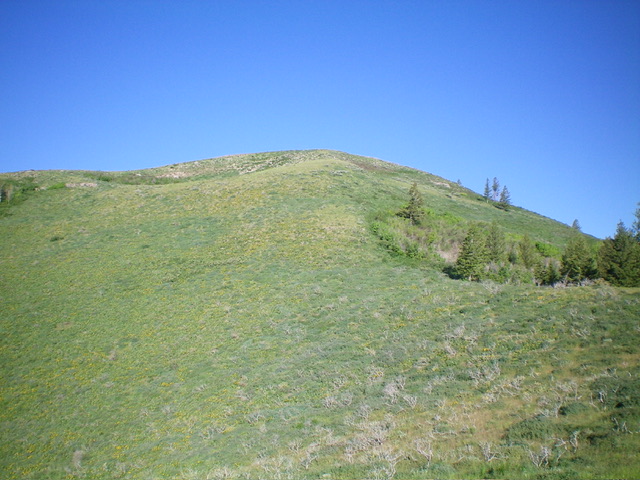
Peak 6864 as viewed from the east. Livingston Douglas Photo

The large cairn atop the unofficial high point with Peak 6868 to the northwest in the distance. Livingston Douglas Photo
Additional Resources
Regions: SOUTHERN IDAHO->Sublett Range
Mountain Range: Sublett Range
Longitude: -112.0307 Latitude: 42.4950