Elevation: 6,905 ft
Prominence: 285
This peak is not in the book. Published November 2020
Peak 6905 is located on the south side of Wood Canyon in the western section of the Pleasantview Hills. It is overshadowed by its close neighbor to the east, Peak 7217. Peak 6905 is most easily accessed via Wood Canyon Road and its east face. Peak 6905 is a mix of dense pine forest and thick brush so it is not an easy climb. Aside from the occasional hunter in the Fall, the peak probably sees few visitors. USGS Ireland Springs
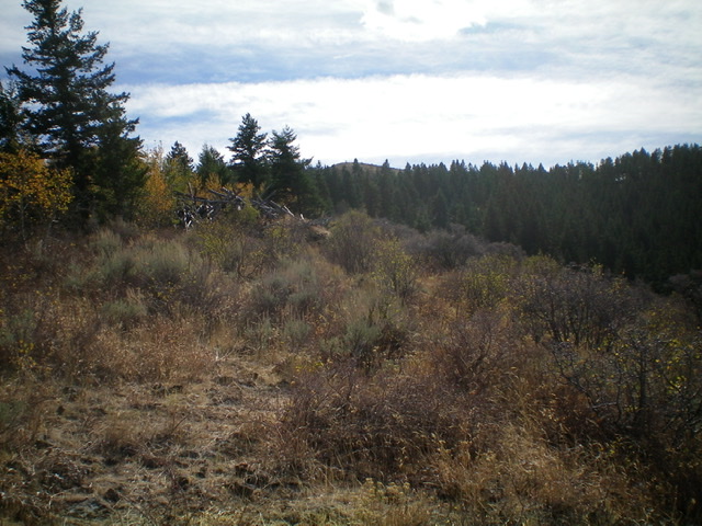
Peak 6905 is the bare hump in the distance (in dead center), as viewed from halfway up the north ridge. Livingston Douglas Photo
Access
From the [signed] junction of ID-38 and Arbon Valley Road (a few miles east of Holbrook, ID), reset your odometer and drive northwest on [paved] Arbon Valley Road. At 1.9 miles, turn right onto [signed] 1000N. This is Wood Canyon Road. Drive east on [narrow] Wood Canyon Road for 4.1 miles to a [signed] road junction at a corral. Park here (5,740 feet) or drive another 0.8 mile up Wood Canyon Road/BLM-610 to the base of the north ridge. The road gets rockier and rougher after reaching the corral.
North Ridge, Class 2
The Climb
From the corral, hike 0.8 mile up Wood Canyon Road/BLM-610 to the toe of the north ridge. This point has a large gully on the right/south side of the road (just before the forested ridge). Wood Canyon Road bends noticeably left/east here as well. Leave the road and follow a use trail southward up into the forest. Always keep that prominent gully on your right/west side when doing this climb. The north ridge is pretty well defined, so you shouldn’t have any navigational issues.
The use trail leads up through the forest and into open terrain on the right/west side of the forest’s edge. Unfortunately, the open terrain is thick brush and sagebrush. The use trail now comes and goes and is overgrown in most spots. The bushwhacking isn’t always fun but it’s better than the ridge crest proper which is often clogged with trees AND brush. Side-hilling in the forest isn’t a good idea since there is copious blowdown and steep angled terrain there.
Stay just to the right/west of the ridge crest and work through the brushy terrain as best you can. You are more likely to find parts of a use trail near the ridge crest than elsewhere, so stay near it. Higher up, the bushwhacking gets somewhat easier. The ridge leads directly to the small, airy summit of Peak 6905. The summit is a gentle hump. There was nothing on top so I built a small cairn.
Additional Resources
Regions: Pleasantview Hills->SOUTHERN IDAHO
Mountain Range: Pleasantview Hills
Longitude: -112.49349 Latitude: 42.19769