Elevation: 6,958 ft
Prominence: 898

This peak is not in the book. Published November 2023
Peak 6958 is the high point on a forested ridge that separates West Fork Hughes Creek to the north from Hull Creek to the south. The easiest access is via Forest Service roads to its west ridge and a ridge climb to the summit. USGS Allan Mountain
Peak 6958 as viewed from the north. Livingston Douglas Photo
Access
From US-93, turn left/west onto [signed] Hughes Creek Road/FSR-091. This junction is located 5.3 miles south of Gibbonsville Road and 5.3 miles north of North Fork. Reset your odometer at this junction. At 2.1 miles, reach a signed junction with FSR-089/Ditch Creek Road. Go straight on FSR-091. At 3.8 miles, reach a signed junction with FSR-088/West Fork Hughes Creek Road. Go left onto FSR-088 and drive 6.4 miles to a 3-way signed junction with FSR-086 and FSR-005/Hull Creek Road at a small saddle. Park here (6,100 feet; 45⁰30’02”N, 114⁰04’23”W).
FSR-086, which heads east along the south side of the west ridge of Peak 6958 is not drivable due to deadfall and cut logs. In addition, it is narrow and overgrown. An alternative way to reach this 3-way junction is from FSR-005/Hull Creek Road to the south. I only drove a short distance up Hull Creek Road to climb Peak 5540 so I do not know the road condition from there (for several miles) up to the 3-way junction. Contact the North Fork Forest Service Office for an update on road conditions in this area.
Map Errors
FSR-096 and its road junction with FSR-086 no longer exist and there are no remnants of the old road. The USGS topo map incorrectly shows FSR-096 crossing the west ridge of Peak 6958 and continuing along the northwest face of the mountain.
West Ridge Variation, Class 2+
The Climb
From the 3-way road junction, hike east on FSR-086 for about ½ mile to a sharp right/south bend in the road. Leave the road and bushwhack left/north up a steep face of thick brush and blowdown (Class 2+) to reach crest of the west ridge. Follow the ridge east up through semi-open pine forest with lots of annoying deadfall and grass/scrub that is thick in areas. The summit had a small cairn which I built up considerably. The summit is semi-open and provides partial views.
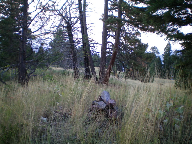
The summit of Peak 6958. Livingston Douglas Photo
West Ridge, Class 2
The Descent
From the summit, descend the west ridge (which is somewhat rounded and ill-defined high up) all the way back to the 3-way junction. The ridge terrain is tedious due to tall field grass, brush, and deadfall. Use a weak, on-and-off game trail to help expedite the descent. Lower down, the use trail disappears due to thick willows on the ridge crest. Skirt the left/south side of the willows to return to FSR-086 a short distance east of the 3-way road junction.
Alternative Climbing Routes
If road conditions are poor, you can climb Peak 6958 via its northeast ridge from Hughes Creek Road/FSR-091. Alternatively, you can climb Peak 6958 via its south ridge from about three miles up Hull Creek Road/FSR-005. Each of these routes appear to go at Class 2.
Additional Resources
Regions: Bitterroot Mountains->NORTHERN IDAHO
Mountain Range: Bitterroot Mountains
Longitude: -114.0587 Latitude: 45.5002