Elevation: 7,070 ft
Prominence: 330
This peak is not in the book. Published December 2019
Peak 7070 is one of several rocky outcrops in the rolling hills east of Muldoon Summit. While most of the terrain is sagebrush, the tops of the hills here are rugged and rocky. The ridge crest terrain is arguably some of the worst in eastern Idaho: loose shale, charred rock/soil, and crumbly lava rock. Peak 7070 is one of two ranked summits in this area, the other peak being Peak 6415 to the south. The land here is a patchwork of BLM land, State of Idaho land, and private land. Consult the BLM Fairfield map to stay out of trouble. USGS Little Wood River Reservoir
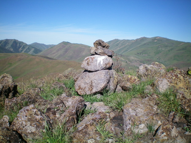
The summit cairn. Livingston Douglas Photo
Southwest Ridge, Class 3
Access
From the junction of ID-75 and Pine Street in Bellevue, drive east on Pine Street (which becomes Muldoon Canyon Road) for 8.0 miles to Muldoon Summit. Park here (6,460 feet).
The Climb
Most of this climb is Class 2. Only the summit area is Class 3. From Muldoon Summit, hike east up a very steep, rock/gravel 2-track jeep road to the top of Point 6895. There is a fence row on the right/south side of the jeep road. Point 6895 is a ridge corner. Turn left/northeast here and follow the rocky open ridge (with some short scrub) northeast to a saddle then east to the base of the summit cliffs/blocks of Peak 7070.
This ridge traverse has numerous ups and downs and will drive you nuts. Scramble up an easy chute through the summit cliffs to reach the narrow, rocky summit ridgeline. There are several rocky outcrops/towers here—the northernmost one is the high point. The summit had a small cairn on the summit boulder so I built it up to a modest size.
South Ridge, Class 3
Access
Same as for the southwest ridge. This is the first leg of a ridge traverse from Peak 7070 to Peak 6415.
The Descent
Most of this descent is Class 2. Only the summit area, the upper south ridge, and the upper reaches of Point 6822 are of Class 3 difficulty. From the summit, descend south on the narrow, rocky ridge through crumbly towers to reach easier rock-and-scrub terrain below. Cruise across a narrow, easy ridge section on short scrub to reach the base of beautiful Point 6822. This point is conical shaped and is more beautiful than either Peak 7070 or Peak 6415. Sometimes being an unranked point is wonderful!
Scramble southeast up easy scrub to reach the summit rocks of Point 6822. This small summit has a nice cairn atop it. From the top of Point 6822, descend south on horrendously loose rock/gullies to reach safer ground below then move left-ish/southeast to make a final descent on easy scrub/grass to reach a gentle saddle at the base of Peak 6415. This saddle is at 6,100 feet and concludes the south ridge descent from Peak 7070.
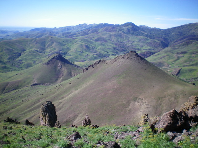
Peak 6415 (left) and Point 6822 (right) as viewed from the summit of Peak 7070. The south ridge descent route goes over Point 6822 and down to a saddle at the base of Peak 6415. Livingston Douglas Photo
Additional Resources
Regions: EASTERN IDAHO->Pioneer Mountains
Mountain Range: Pioneer Mountains
Longitude: -114.09719 Latitude: 43.48839