Elevation: 7,096 ft
Prominence: 836
This peak is not in the book. Published January 2023
Peak 7096 is located east-southeast of the magnificent spires of the Twin Sisters in the City of Rocks National Reserve. This area is a mix of private and public land. Thankfully, this climb is entirely on BLM land and a 2-track access road that is open to the public. This climb covers 5.0 miles with 1,600 feet of elevation gain round trip. USGS Almo
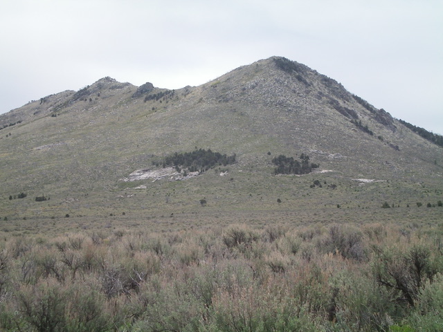
Peak 7096 (summit is left of center) as viewed from the northwest. The rocky, steep northwest ridge of Point 7088 is right of center. Livingston Douglas Photo
Access
From the City of Rocks Visitor Center at the south end of Almo, drive south on ID-77 for 0.4 miles to a signed junction with the City of Rocks Road. Turn right/west onto the City of Rocks Road. Drive 4.0 miles to a signed junction with Twin Sisters Road. Turn left/south onto Twin Sisters Road and drive 2.3 miles to unsigned “Twin Sisters Pass” which is the high point of the road and is between Twin Sisters Campground and the Group Campground. Park in a nice pullout on the south side of the pass (6,255 feet).
Northwest Shoulder/West Ridge, Class 2+
The Climb
From the parking pullout, walk south on Twin Sisters Road to the entrance to the Group Campground, which is on the left/east side of the road. Walk along the road into the Group Campground and quickly find an unsigned 2-track heading right-ish/south. Follow this 2-track road as it skirts the west side then the south side of Peak 6559 (a magnificent rocky spire) and merges into the old California Trail. The California Trail heads northeast then north up over a notch (Pinnacle Pass on the City of Rocks map) just east of Peak 6559. The trail then drops north-northeast into a broad sagebrush gully.
Leave the old trail soon after it drops from Pinnacle Pass and contour right/east through thick sagebrush, aiming directly at the [obvious] northwest shoulder of Peak 7096. You must drop about 50 vertical feet and cross a dry gully to reach the base of the northwest shoulder. Scramble east up through a combination of sagebrush, snags, and fallen timber to reach the crest of the shoulder. Climb southeast up the ridge through a mess of brush, downed snags, and quartzite talus. Lots of weaving is necessary here. Higher up, the slope steepens considerably and becomes a combination of quartzite blocks/boulders and downed snags (the brush isn’t too bad). This section is quite steep and goes at Class 2+/3.
Reach the west end of the west ridge at Point 7088. Point 7088 is a small, rocky affair (see photo) and the connecting ridge to Peak 7096 is a mess of quartzite boulders/talus, brush, and downed snags. Stay to the right/south of the ridge crest to avoid ridge chop and the rocky “middle hump.” There are sections of talus and grass with some downed snags to navigate, but it goes pretty quickly. The final push to the top of Peak 7096 is a bit tedious and is mostly quartzite blocks/talus (Class 2+/3). Stay on the ridge crest here to reach the rocky summit. The summit of Peak 7096 is composed of large quartzite blocks that can easily be stood upon. A triangulation post and wiring are nearby. There is no summit cairn.
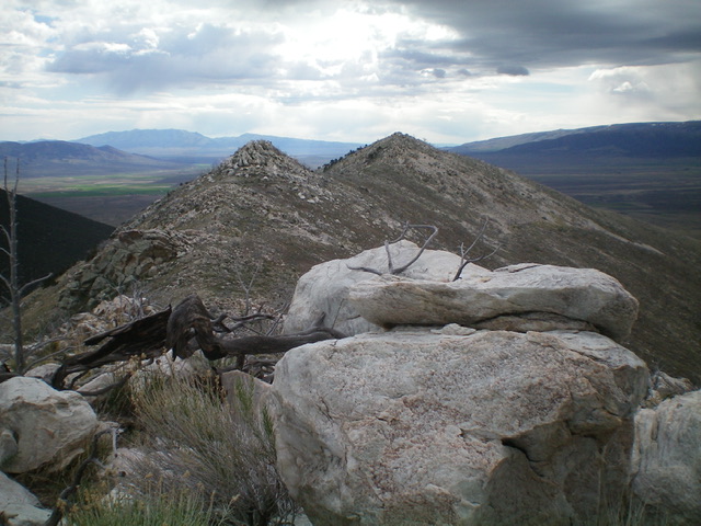
The rocky summit ridge of Peak 7096 (dead center) as viewed from Point 7088 to its west. A rocky tower protrudes in between. Livingston Douglas Photo
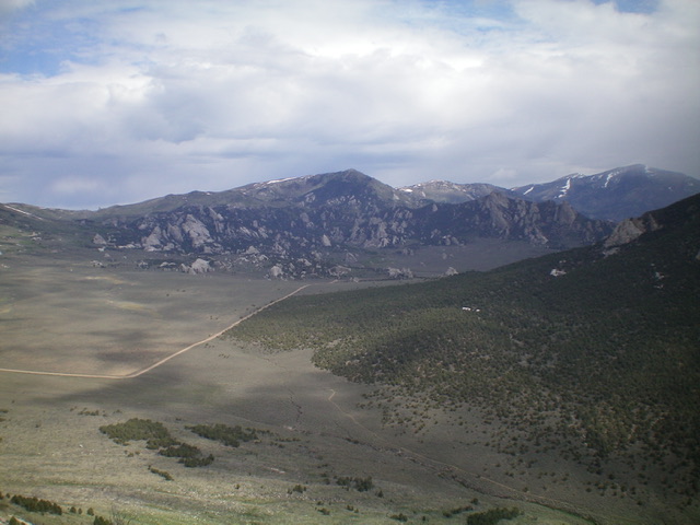
View of the City of Rocks from the summit of Peak 7096 to its south. Livingston Douglas Photo
North Face, Class 2+
The Descent
From the summit, descend northwest down a steep upper section of quartzite blocks/talus and brush with some downed snags thrown in to make things miserable. This is a tedious, but thankfully short, section. You will soon reach a wonderful wide gully of grass and easy scrub with a decent gravel base. Cruise north down this gully which morphs into a face to about 6,400 feet. From there, do a diagonal left/northwest descent to reach 6,250 feet. Contour west at that level on easy grass/scrub with some downed snags to maneuver around.
As you approach the final dry gully crossing, drop down to 6,200 feet to cross the gully and begin the westbound ascent toward Pinnacle Pass. Intercept the California Trail just below the pass and follow the trail back to the unsigned junction with the 2-track road that heads right (west then northwest) back to the Group Campground and Twin Sisters Pass. This descent route is much gentler and less rocky than the ascent route up the northwest shoulder and west ridge.
Additional Resources
Regions: Albion Range->SOUTHERN IDAHO
Mountain Range: Albion Range
Longitude: -113.69191 Latitude: 42.0361