Elevation: 7,183 ft
Prominence: 363
This peak is not in the book. Published November 2023
Peak 7183 is located on the east side of the Salmon River near the confluence of the East Fork and the Main Fork of the Salmon River. It is most easily climbed from ID-75 via a gully to its north. Both Peak 7183 and its sister peak to the north are handsome, rocky affairs that require Class 3 scrambling to reach their respective summits. USGS Bald Mountain
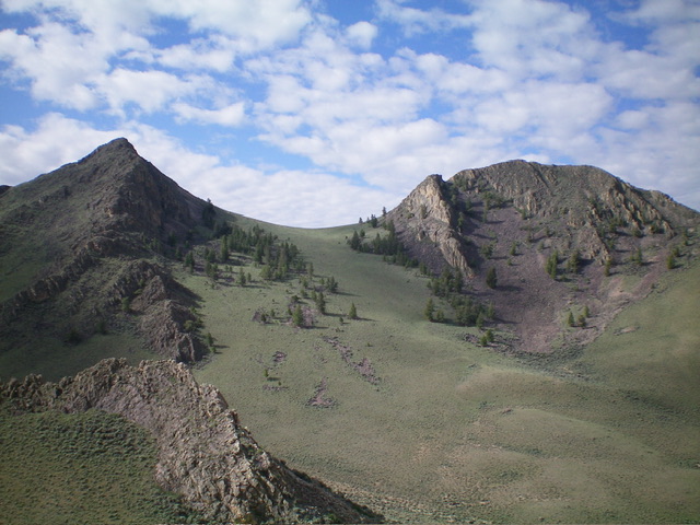
Peak 7183 (left) and Point 7040+ (right) as viewed from the north. My ascent route climbs to the saddle between them then climbs leftward up the west face to the summit. Livingston Douglas Photo
Access
Park along ID-75 in a large pullout alongside a water metering station (fenced with three water wheels rotating) at MM229. The pullout is 15.0 miles south of the ID-75/US-93 junction south of Challis and 1.9 miles northeast of the East Fork Road junction. The large pullout is at 5,340 feet and 44⁰17’15”N, 114⁰18’11”W. This area is a mix of private land and BLM land. This climb is entirely on BLM land. This is the first leg of a 2-peak adventure that includes Peak 7183 and Peak 6820. It covers 4.5 miles with 2,550 feet of elevation gain round trip.
West Face, Class 3
The Climb
From the parking pullout, cross to the east side of ID-75. Bushwhack briefly east up a dry gully of sagebrush then leave it to climb right/south onto a shoulder just past a steep, rocky point at its base. Once on the shoulder, scramble southeast then east up to its end in easy scrub and stable underlying talus/scree. The shoulder has a few rocky outcrops but nothing serious. The shoulder ends near the head of the aforementioned dry gully. Drop about 30 vertical feet to the grass/sagebrush head of the gully to a saddle of sorts.
From there, descend diagonally right/southeast into an upper gully. This gully is narrow, dry, and has tall, thick sagebrush in it with angled talus/scree on its sides. Not very pleasant. Bash up this narrow gully (staying in its center or nearby) until it ends at a blissful, short “headwall” of short, gapped sagebrush and field grass that quickly places you in a wide-open, easy basin of scattered, short sagebrush and field grass.
Angle diagonally right/southeast then right/south to scramble up to the saddle between Point 7040+ and Peak 7183. Point 7040+ is a very rocky mess—avoid it. From the gentle scrub saddle, scramble directly east up the face of boulders, thick sagebrush, cliff bands, and talus/scree slopes (Class 3 in sections) to reach the small summit of Peak 7183. The summit has a modest cairn and great views of the Salmon River Valley.
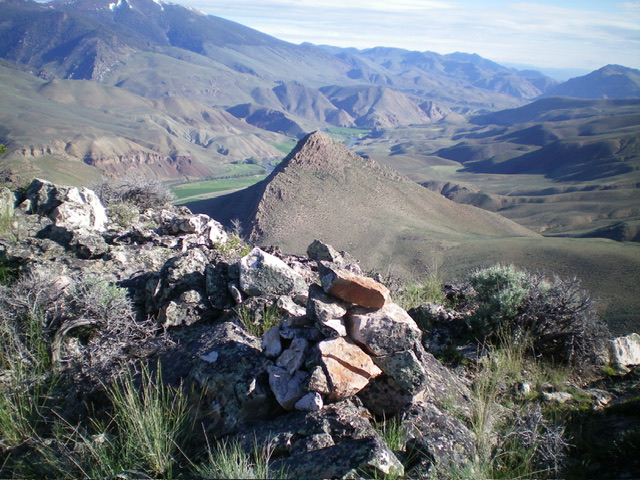
The summit cairn atop Peak 7183 with the Salmon River Valley in the distance. Livingston Douglas Photo
North Ridge, Class 3+
The Descent
From the summit, descend the steep, rocky north ridge, aiming directly at Peak 6820. The north ridge goes surprisingly well in several sections (Class 2 or easy Class 3). In other sections, it is Class 3/3+ and requires careful downclimbing. The entire north ridge is rocky and has unending ridge outcrops/towers, most of which are not difficult. About midway down the ridge, I got cliffed out and had to backtrack and downclimb the left/west side of this ridge buttress/tower. Stay on or close to the ridge crest and occasionally skirt the crest to make progress in the descent.
Upon reaching the final lower section of ridge chop, leave the ridge and descend right/northeast to reach the easy scrub on the valley floor. This part of the descent is on loose talus/scree with some scrub mixed in. It is somewhat steep and must be done with care. Once in the non-rocky scrub, drop to cross a wide, dry gully at about 6,300 feet. This is the low point in the traverse from Peak 7183 to Peak 6820. It concludes the first leg of today’s 2-peak adventure. Peak 6820 is up next.
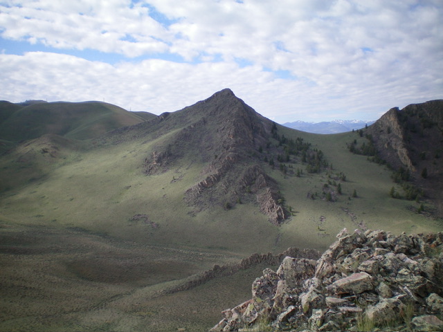
Peak 7183 and its rugged north ridge (in dead center). The north ridge was my descent route. Livingston Douglas Photo
Additional Resources
Regions: Boulder Mountains->EASTERN IDAHO
Mountain Range: Boulder Mountains
First Ascent Information:
- Other First Ascent: North Ridge (Descent)
- Year: 2023
- Season: Summer
- Party: Livingston Douglas
Longitude: -114.2827 Latitude: 44.2760