Elevation: 7,254 ft
Prominence: 714

This peak is not in the book. Published November 2023
Peak 7254 is the higher of two humps on a high ridge that sits above Lamb Gulch to the south and Osborn Gulch to the east. This area of the Smoky Mountains is just northwest of Hailey. Peak 7254 towers above Deer Creek to the north but the Deer Creek approach is blocked by private land. USGS Mahoney Butte
Peak 7254 (left of center) and Point 7186 (right of center) as viewed from the southwest spur to its west. Livingston Douglas Photo
Access
From downtown Hailey on ID-75, drive west then southwest on Bullion Street (which becomes Croy Creek Road) for 1.6 miles to a signed junction with Democrat Gulch Road. Turn right/west onto Democrat Gulch Road and follow it west then northwest for 2.6 miles to a pullout on the left/west side of the road at 5,790 feet (43⁰30’58”N, 114⁰23’23”W). The road becomes narrow and impassable about 0.1 miles above this pullout. It becomes steep, rocky, and badly rutted and is only suitable for ATVs. A creek flows down the road in the initial, rocky, narrow section. It’s dreadful. This area is a mix of private land and BLM land, so be careful. Democrat Gulch Road crosses a lot of private land, most of which is not posted. Peak 7254 is mostly on BLM land and most of the road hike is also on BLM land.
Map Errors
No maps show the useful 2-track road that leaves Democrat Gulch Road just below the first minor saddle and heads up the southwest spur of Peak 7254.
Southwest Spur/South Ridge, Class 2
The Climb
From the pullout, hike northwest then north on Democrat Gulch Road for about 1-1/2 miles to an unsigned junction with a weak 2-track road heading right/east up to the crest of the southwest spur from a gully of sorts. Regrettably, this old road flames out pretty quickly. Continue southeast then east then northeast on the weaving ridge crest in mostly easy scrub/scree/gravel, up over rocky Point 6759 then down to the final major ridge saddle at 6,540 feet.
From the saddle, scramble east then northeast over a final ridge hump then climb northeast then east up the ridge to rocky Point 7186, the south summit. The final section of this climb is on a decent talus slope. From Point 7186, descend north for 140 vertical feet to a saddle then up over another ridge hump to do a final 35-foot drop that precedes the final, easy push to the summit in easy scrub.
The summit is small and has a modest cairn. It offers a beautiful view of the Big Wood River Valley to the northeast. From the summit, Peak 6628 (a gentle ridgeline peak) is visible about a mile to the northwest but there is a massive, deep drainage in between.
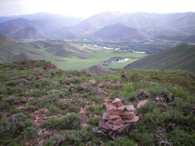
View of the Big Wood River Valley from atop Peak 7254. Livingston Douglas Photo
West Gully, Class 2
The Descent
From the summit, descend the south ridge to about 7,080 feet then angle diagonally right/southwest to intercept a nice shoulder that descends the right/north side of a major gully (the west gully). This shoulder actually splits the main gully from a minor gully, both of which are on the west side of the Peak 7254 massif. Follow this easy scrub shoulder down to its end in the west gully then continue west down the veg-filled gully to its end where a wet drainage comes in from the left/south. Cross this drainage at about 6,100 feet. This is the low point in the traverse from Peak 7254 to Peak 6628. It concludes the first leg of today’s 2-peak adventure. Peak 6628 is up next.
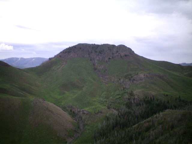
Peak 7254 as viewed from Peak 6628 to its northwest. Livingston Douglas Photo
Additional Resources
Regions: Smoky Mountains->WESTERN IDAHO
Mountain Range: Smoky Mountains
Longitude: -114.3781 Latitude: 43.5446