Elevation: 7,515 ft
Prominence: 415
This peak is not in the book.
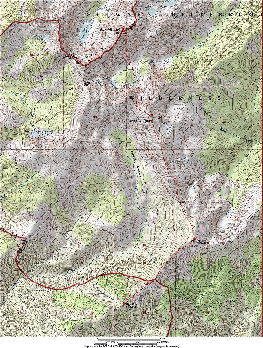
Peak 7515 is located a little NNW of Big Fog Mountain between the upper Canteen Basin and Three Links Creek in the Selway Crags, or simply, the Crags. These highly sculpted jumbles and precipices of Idaho Batholith granite occupy the divide between the Lochsa and Selway Canyons in the Clearwater Basin of North Central Idaho. USGS Fenn Mountain
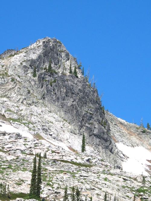
The Southeast Aspect of Peak 7515. Mike Hays Photo
Peak 7515 is formed by a precipitous, yet relatively small, protrusion of dark granite on the ridgeline just to the northwest of Legend Lake. The ridge runs perpendicular into another ridge that forms the south side of the South Three Links Basin. Peak 7515 rises nearly 6,000 feet over the lush warm cedar forests of the Selway River. The immediate rise over the Canteen Basin at its west foot is nearly 1,500 feet. It rises approximately 1,200 feet above the wet meadows at its east foot and over 4,500 feet from the confluence of Three Links Creek and the West Fork of Three Links Creek.
The high point forms a pyramid with the west side sloping up gradually before rising abruptly to form the outcrop summit. The east side is much more spectacular, forming a 300-foot wall that drops off onto some benches breaking above Legend Lake. The north side drops to an open ridgeline that proceeds north before dropping 1,200 feet into a series of cliffs and broken slopes to the lower South Three Links Lake.
The mountain probably sees few visitors, though it’s probably busier than most points in the Selway Crags. This is because Legend Lake is one of the most accessible points from the Big Fog trailhead which is the best entrance to the Crags. Also, one of the main routes into Fenn Mountain and the central crags is over this ridge from the trailhead.
Access
To reach the Big Fog Trailhead, parallel the Selway River from US-12 at Lowell almost to Selway Falls, about 18 miles. The first several miles are paved, but most of the road is gravel. Some places are narrow and traffic can be heavy at times, so watch the corners. Just before Selway Falls, take a left on Fog Mountain Road/FSR-319. This road is well-signed. From the Selway River, the trailhead at road’s end is 13 miles. The first half of this road is narrow but in fair condition. The second half of the road gets progressively rougher, with large jutted rocks and seasonal streamlets breaking up the surface. A high-clearance vehicle is advised. It takes over an hour to drive the 13 miles to the trailhead.
Southeast Ridge Route via Fog and Big Fog Mountains, Class 2+
Once at the trailhead, take FST-343 to the east. This trail climbs fairly steeply before leveling off on a ridge, giving tremendous views of the Canteen Creek Basin and the central Crags beyond. Follow the trail as it skirts Fog Mountain (or summit Fog Mountain) before it drops to a saddle before rising up the broad summit dome of Big Fog Mountain approximately 2 miles from the trailhead. Just before the Big Fog Mountain summit, the trail splits with FST-343 going east and FST-363 continuing a short distance over the summit and to the NNW toward Peak 7515.
The trail may briefly disappear. Just continue hiking along the open, stunted subalpine forest over Point 7315 and toward Peak 7151 until the broad ridge narrows and the trail returns. Continue along the ridge’s easier west side to reach the summit. From here, one can reverse the approach back to the trailhead or continue on the trail and down the Peak 7515’s east side, eventually reaching Legend Lake where good camping can be found.
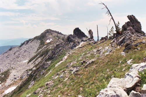
The ridge route. Mike Hays Photo
This GPS track was provided by Dave Pahlas.
Other Routes
From the Big Fog trailhead, it is also possible to hike 6 miles on FST-031 to Cove Lakes for a base camp. The ridge above the lakes can be ascended to a nice ridge hike north, then east around the head of the Canteen Basin after 2-3 miles depending on the route. There are other routes into this area from ID-12 to the north and the Coolwater Ridge trailhead to the west. However, these are much farther away and make the approach a multi-day affair.
[Editor’s note: This Peak can also be climbed from Jesse Pass. See the Fenn Mountain page for additional details.]
Contacts and Additional Information
Consult local maps and Forest Service offices before confirming desired routes. Keep in mind that many trails in the area do not actually exist on the ground and cross-country travel in this terrain can be difficult. Many years the trails and slopes are free of snow by mid-July but, in heavy snow years, some high ground may not lose snow cover until Fall if at all. Contact the Moose Creek Ranger District of the Nez Perce National Forest for information and current conditions.
Moose Creek Ranger District/Fenn Ranger Station
831 Selway Road
Kooskia, ID 83539
(208) 926-4258
Office hours
Mon-Fri, 7:30-4:00
The north side of the Lochsa/Selway Divide is located on the Clearwater National Forest, Lochsa Ranger District.
Lochsa Ranger District/Kooskia Ranger Station
Route 1 Box 398
Kooskia, ID 83539
(208) 926-4274
Additional Resources
Mountain Range: Central Clearwater Peaks
Year Climbed: 1988
Longitude: -115.19489 Latitude: 46.15739