Elevation: 7,696 ft
Prominence: 916
This peak is not in the book. Published November 2020
Peak 7696 is sandwiched between Champagne Creek to the east and Dry Creek to the west. Its east slopes are gentle but its west side is steep. You must thread a needle in order to remain on public land to and from the summit of Peak 7696. Most of the peak’s aspects are inaccessible due to private land. Be sure to consult a current map with accurate lines for public and private land before undertaking a climb of this peak. The route detailed below is entirely on BLM land. USGS Champagne Creek
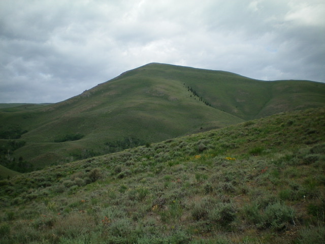
Peak 7696 and its northeast shoulder (in center of photo, coming directly at the camera). Livingston Douglas Photo
Access
From the junction of US-93 and US-20 in downtown Arco, ID, drive west on US-20 for 5.1 miles. Turn diagonally right/west onto [unsigned] Blizzard Mountain Road. Drive 8.7 miles on Blizzard Mountain Road to a signed junction with Champagne Creek Road (signed with a simple street sign as “Champagne”). Turn right/west onto Champagne Creek Road and drive 3.7 miles to a large parking pullout/camping area on the right/east side of the road (5,925 feet) at the mouth of a gully. This is the old Era townsite and is on BLM land.
Northeast Shoulder, Class 2
The Climb
From the large parking pullout, cross to the west side of Champagne Creek Road and drop down to Champagne Creek. There is a lot of brush in here and, while the creek is small, you must look for a good place to jump it. I found a spot where a cattle trail crosses it just downstream from the road entry point. Once across Champagne Creek, angle left/southwest to get closer to the fence row that heads west. This fence row is the property line so stay right/north of it to remain on BLM land.
Follow the fence row (or stay well to the right/north side of it) up over a minor ridge and down a dry gully to cross another small stream (90-foot vertical drop). Cross the small stream and continue to follow the right/north side of the cattle fence as it crosses a 2-track road (the old Poison Gulch Road, now closed to the public below this point). Soon after this, the cattle fence has another cattle fence coming up to it from the left/south, creating a fence corner. This corner is critical and shows up on the National Forest map but not on the USGS topo map. Stay west or north of this corner and you will be on BLM land. When you later descend from Peak 7696, you MUST find this corner in order to find the fence row that heads east and returns you to Champagne Creek Road entirely on BLM land.
From the corner, continue to head west to cross a shoulder, following a dilapidated BLM cattle fence for a short distance. That fence turns right/north. Cross it to continue your westward journey. You must now figure out a way to angle your way down into Poison Gulch and cross it. From the south side of the shoulder, Poison Gulch is directly below and to the left/south. You will find cattle trails to allow you to contour along the south side of the shoulder until you find a spot from which you wish to descend to Poison Gulch.
Drop steeply south and cross the creek in a muddy, forested area that is a real mess. Avoid the thick, tall willows as best you can. You will quickly emerge on the west side of this drainage onto the open scrub of the toe of the northeast shoulder of Peak 7696. The hard work and difficult navigation is now over. From here, it is just a grind up the open scrub and sagebrush of the shoulder. Climb steeply northwest initially to reach a flat corner point in the shoulder. From there, head left/southwest up generally easy short scrub. There are a few areas of thicker scrub and some underlying loose scree but, overall, it’s not too bad. The slope steepens and gets rockier as you approach the summit.
The summit of Peak 7696 is a narrow ridge crest. The summit had a large, torn-down cairn so I rebuilt it. The summit offers beautiful views since Peak 7696 is the high point in the immediate area. Timbered Dome still dominates the overall area (at 8,356 feet) and it is visible to the northeast. Aside from the fencing (and a map showing the property lines), the private property is only marked with orange paint at Champagne Creek Road and atop the first minor ridge crossing early on. After that point, there is no signage or orange paint anywhere along the fence row/property line. Respect the line anyway. After all, this is IDAHO.

Magnificent Peak 7696 (left of center) as viewed from Champagne Creek Road to the east. Livingston Douglas Photo
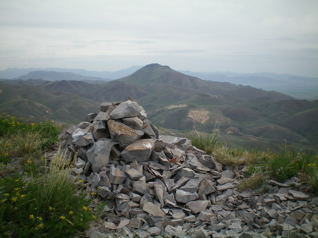
The summit cairn atop Peak 7696 with Timbered Dome in the distance. Livingston Douglas Photo
Additional Resources
Regions: EASTERN IDAHO->Pioneer Mountains
Mountain Range: Pioneer Mountains
Longitude: -113.61189 Latitude: 43.57429