Elevation: 7,750 ft
Prominence: 340
This peak is not in the book. Published November 2020
Peak 7750 is a forested hump due south of Dry Creek Peak. It separates Moose Creek from West Dry Creek. Peak 7750 could be considered just a bump on the long south ridge of Dry Creek Peak. It is best climbed in combination with Dry Creek Peak from the 7,410-foot connecting saddle and its north ridge. Elk really enjoy this mountain and have many well-beaten trails on the peak’s north ridge, west face, and the connecting saddle. It’s impressive. Contrary to the USGS topo map, there is no trail crossing the connecting saddle and a bushwhack is required to reach this summit. The USGS topo map is also atrociously wrong on the roads and road positioning in this area, so be careful. USGS Antelope Valley
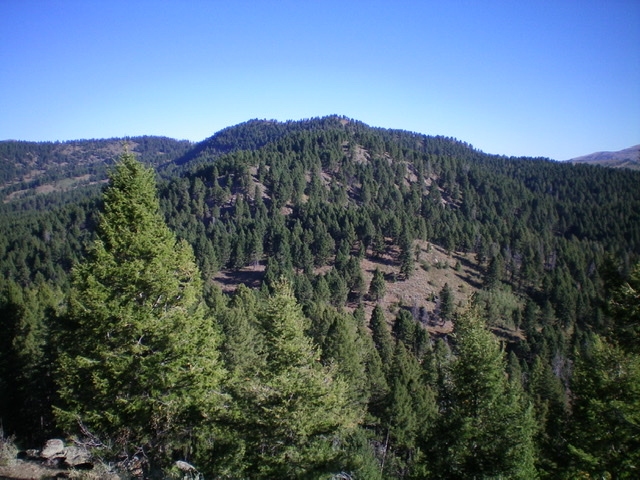
Peak 7750 (dead center) and the open pine forest on its north face/ridge. Livingston Douglas Photo
Access
Same as for Dry Creek Peak. This is the final leg of a 2-peak journey that begins at the Aldous Lake/CDT trailhead.
North Ridge, Class 2
The Climb
From the 7,410-foot connecting saddle with Dry Creek Peak, follow an elk trail that climbs the crest of the forested north ridge. The north ridge is much better defined than the USGS topo map indicates. The pine forest is open and easy, even without the help of an elk trail. The summit is only 340 feet above the saddle so you will reach it quickly. But where exactly is the summit? Based on the USGS topo map, the summit ridge has a measured point at its north end (Point 7730) but that is NOT the high point because there is a higher contour line south of it (7,740 feet). The summit is above that small, final contour line—an interpolated elevation of 7,750 feet according to LOJ. Point 7730 is the first open point on the summit ridge. The true high point is the next high point on the narrow, rocky ridge crest. It is also in semi-open terrain.
I wandered along the summit ridge (there are actually two separate ridge lines—only one is shown on the USGS topo map) and determined that the high point is not too far south of Point 7730, perhaps 50 yards or so. There was no cairn on the high point, so I built one there. I wandered well south of this point, looking for a higher point, but there was none. The ridge heads slowly downhill from this my perceived high point but, since the terrain is forested, you can’t be sure unless you walk south and know (via altimeter) that you are losing altitude, which I did.
West Face, Class 2
The Descent
The goal of this descent is to reach the Moose Creek drainage due west of the summit (with three small ponds on the USGS topo map) and, from there, to locate Moose Creek Road/FSR-564 and hike back to Aldous Lake Road/FSR-027 on it. Please note that the USGS topo map has the roads and road positions COMPLETELY WRONG, so you must ignore that map and go with the Caribou-Targhee National Forest Map to correctly find Moose Creek Road and how/where it connects to Aldous Lake Road.
From the summit, descend west and a bit northwest down through the somewhat-brushy pine forest. You will cross numerous lateral elk trails on your way down the west face. Just keep working your way downward, sometimes descending a gully or a shoulder in so doing. Let the terrain push you down to the Moose Creek drainage. It’s really that easy. As you approach the Moose Creek drainage, find cattle trails and use them to expedite your descent to Moose Creek Road. The primary creek heads west to reach an open meadow then bends left-ish/southwest and soon intersects a jeep road. Trust the National Forest map. This must be Moose Creek Road and it is. Go right/west on Moose Creek Road and follow it as it meanders its way west and northwest, with some ups and downs, to reach its [signed] junction with Aldous Lake Road. Go right/north on Aldous Lake Road and walk 0.9 miles to the Aldous Lake/CDT trailhead and your parked vehicle.
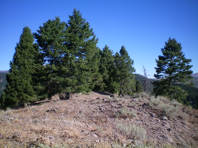
The summit area atop Peak 7750. Livingston Douglas Photo
Additional Resources
Regions: Centennial Range->EASTERN IDAHO
Mountain Range: Centennial Range
Longitude: -111.80401 Latitude: 44.48679