Elevation: 8,060 ft
Prominence: 280
This peak is not in the book. Published January 2023
Peak 8060 is a ridgeline summit that sits above Pine Creek and at the head of Camel Hollow in the Gannett Hills. It is most easily climbed from nearby FSR-595/Camel Hollow Road. USGS Elk Valley
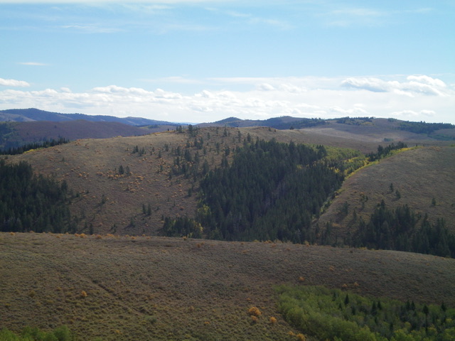
Peak 8060 (in mid-ground) as viewed from Peak 8024 to its northwest. Livingston Douglas Photo
Access
Crow Creek Road/FSR-111 is located at the west end of North Fairview Road/CR-236, about three miles west of US-89 at the hamlet of Fairview, WY. Reset your odometer at the signed junction of Crow Creek Road and North Fairview Road. Turn left/south onto Crow Creek Road. At 8.4 miles, reach the Caribou National Forest boundary. At 9.7 miles, reach a signed junction with FSR-740 at Quaking Hollow. At 11.4 miles, reach an unsigned junction with FSR-595 just after a bridge crossing of Deer Creek. Park at this junction (6,574 feet). GPS coordinates: 42⁰35’00”N, 111⁰08’10”W. FSR-595 is a rough road with an impossibly deep fording of Crow Creek not far from this junction. It does, however, make for a decent hiking route up Camel Hollow, the creek ford notwithstanding.
Map Errors
The Caribou-Targhee National Forest map shows trailheads for Camel Hollow and Deer Creek which don’t exist. The USGS topo map shows a jeep road in the Pine Creek drainage but it is only a foot trail. The USGS topo map also shows a trail junction in the meadow near Pine Creek with a trail (FST-573) heading northwest up to Peak 8024. There is no such trail junction though FST-573 does still exist on the south ridge of Peak 8024.
West Face, Class 2
The Climb
From the road junction, hike east along FSR-595 and quickly reach a wide, deep fording of Crow Creek (thigh deep at its deepest point). Please note that on the descent, I forded Crow Creek near Crow Creek Road at a much shallower crossing that is located about ¼ mile downstream from the aforementioned bridge crossing and road junction. Much, much better. Once across Crow Creek, follow FSR-595 up Camel Hollow, reaching a gated road closure almost immediately. The old road is only open to ATVs beyond this point.
Hike up the somewhat-muddy, weaving ATV trail all the way to its end at a signed junction with FST-147 in a meadow at the base of the west face of Peak 8060. Hike briefly right/south up FST-147 then leave the trail to bushwhack left/east and drop 20 feet to cross a dry gully. Continue east up on a shoulder of aspens and pines, using a cattle trail to expedite your ascent. Once above the forested area, scramble east up somewhat-tedious sagebrush to reach a ridgeline and Point 8000+.
This is not the summit ridge, which is one more ridge to the east. Follow an old 2-track road (shown on the USGS topo map) north on this ridge then east down to a saddle of sorts then east up onto the summit ridge. Once on the summit ridge, hike north about 100 yards or so in easy, short scrub to reach the ridgeline summit of Peak 8060.

The summit of Peak 8060 with its newly-built summit cairn. Livingston Douglas Photo
Descend back to the trail junction in the meadow near Pine Creek. This concludes the first leg of today’s 2-peak adventure. Peak 8024 is up next.
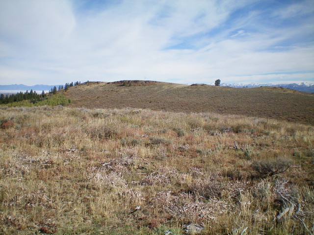
The elusive summit hump of Peak 8060 as viewed from Point 8000+ to its southwest. Livingston Douglas Photo
Additional Resources
Regions: Gannett Hills->SOUTHERN IDAHO
Mountain Range: Gannett Hills
Longitude: -111.0899 Latitude: 42.5742