Elevation: 8,170 ft
Prominence: 710
This peak is not in the book. Published December 2019
Peak 8170 is arguably one of the toughest mountains in the Arco Hills. It is more of a rugged mountain than a gentle hill. It has numerous rock faces and cliffs on its west and southwest aspects. The easiest ascent route is via its north ridge from Wood Canyon Trail. USGS Arco Hills
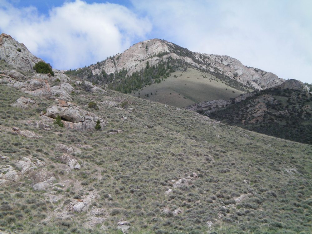
The west face of Peak 8170. Livingston Douglas Photo
Southwest Spur/Northwest Ridge, Class 2
Access
At the south end of Arco, ID, along US-20/26, there is a frontage road (Highway Drive) on the east side of the highway. Just north of the Conoco gas station, look for the Lost River Motel on the right/east side of the highway. Find an access road here that goes east to intersect Highway Drive. There is a public park of sorts here with a picnic table. When you reach the “T” junction with [signed] Highway Drive, turn right/south and drive 0.3 miles to a [signed] junction. Go left/east here onto 2450N. This junction is directly east of the Conoco gas station.
Drive 1.0 mile on 2450N to a signed road junction. Go left/north here. This is the start of Arco Pass Road. Reset your odometer here. At 3.6 miles, the road turns right/east at a corral. At 4.8 miles, you reach a signed road junction. Go left/north here for Arco Pass. Instead, continue straight/east. At 6.8 miles, the road crosses a cattle guard and bends left/northeast. At 7.8 miles, the road turns right/east. At 8.7 miles, reach a signed road junction. Go straight here for Wood Canyon. At 8.8 miles, the road turns left/north. At 8.9 miles, reach another road junction. Go straight here for Wood Canyon. At 9.5 miles, there is a grassy campsite on the left side of the road. Park/camp here (6,090 feet).
The Climb
From the parking/camping pullout at the mouth of Wood Canyon, scramble east through sagebrush up onto the toe of the southwest spur of the northwest ridge. Follow the right/southeast side of the rocky ridge crest on easy, open scrub (which thins out and shortens quickly) to reach Point 6910. Continue grinding your way up the ridge as it curves right/east then right/southeast to reach a mix of forest and rocky outcrops at about 7,300 feet.
From here, the terrain is a mix of rocky buttresses/towers/blocks (easy to skirt), short open areas of easy broken scree/scrub/grass, and unpleasant forest (mostly mountain mahogany with some pines mixed in). The west gully (an easy, grassy gully that narrows high up but gets within about 200 vertical feet of the summit) is on your right/south side as you finish the northwest ridge to reach the summit ridge. Scramble south for a short section to reach the ridge crest summit. There is a modest cairn on top. The [lower] false summit is to the southeast on a long, narrow ridge.
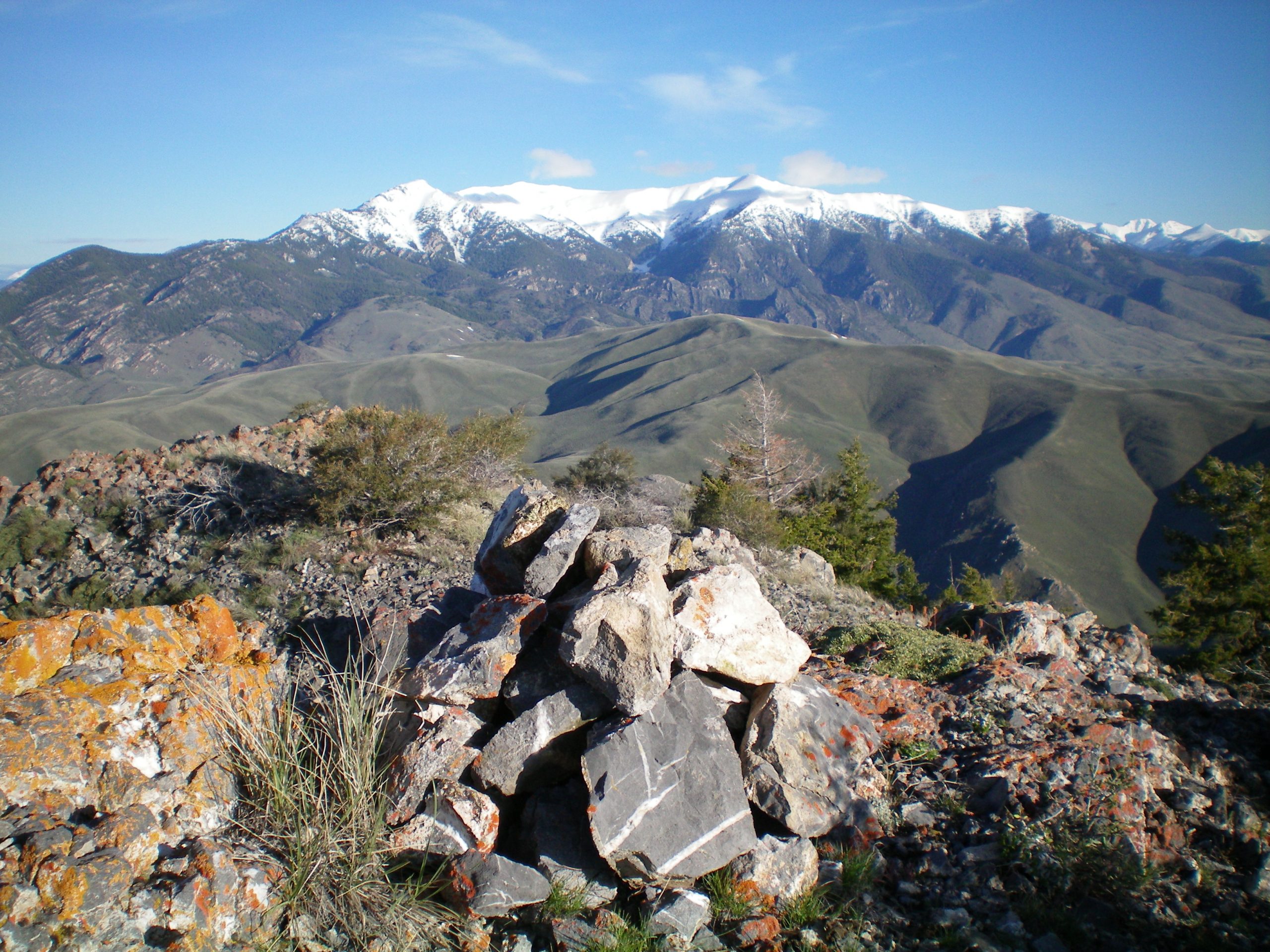
The summit cairn atop Peak 8170 with snow-covered King Mountain and North King Mountain in the background. Livingston Douglas Photo
West Ridge, Class 3+
Access
Same as for the southwest spur/northwest ridge
The Descent
From the summit, descend directly west and stay close to the ridge crest. Move left/south to avoid any ridge difficulties. You will soon arrive at a major mess of ridge towers and knife-edged buttresses. Drop off the left/south side of the ridge via ledges on a tower/fin to get to easier terrain below (Class 3+/4). This gets you down to another rocky block, which can be skirted on its left/south side. After passing that block, you soon reach an open scrub/grass hillside on the [now] gentle west ridge.
Cruise down this section with ease. The ridge wiggles a bit—west then southwest then west then south—to reach the valley floor. There are two minor rock humps along this final section. Once on the valley floor, angle left/southeast to intercept the 2-track jeep track going up Combe Canyon about ¾ mile up from Wood Canyon Road. This is the terminus of the west ridge. The next leg of this journey is a climb of nearby Peak 7194.
Additional Resources
Regions: EASTERN IDAHO->Lost River Range
Mountain Range: Lost River Range
First Ascent Information:
- Other First Ascent: West Ridge —Descent
- Year: 2019
- Season: Spring
- Party: Livingston Douglas
Longitude: -113.15049 Latitude: 43.72269