Elevation: 8,208 ft
Prominence: 988
This peak is not in the book. Livingston Douglas added new routes and new photos. Updated November 2023
This peak, unofficially named Bradshaw Peak, rises precipitously above Spar Canyon Road in the Northern Boulder Mountains. Offering nearly a thousand feet of prominence, this peak is a great viewpoint for surveying the surrounding terrain. Use the link below to read Rick Baugher’s trip report, which explains the basis for the proposed name. USGS Lone Pine Peak
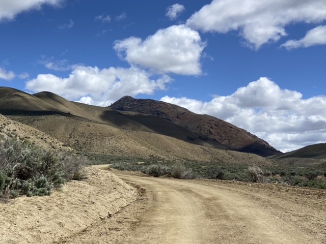
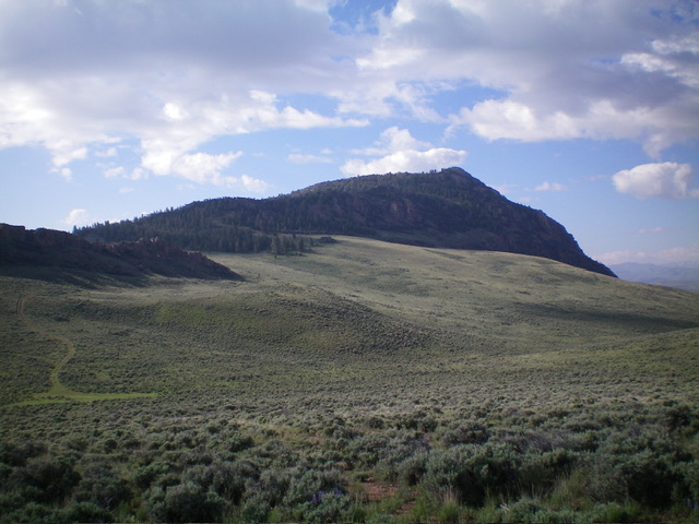
Bradshaw Peak as viewed from Spar Canyon Road to the west
Access
Spar Canyon Road is the primary access for the Northern Boulder Mountain peaks [(D)(1) on Page 243]. Spar Canyon Road can be accessed from US-93 in the east or from East Fork Salmon River Road in the west. The road is maintained except during the Winter. It is subject to occasional flash floods and can be difficult to drive when wet. All of the side roads departing from the Spar Canyon Road require high-clearance vehicles and 4WDs are recommended.
To reach the 4WD road that accesses the route described below from US-93, follow Spar Canyon Road west for 7.5 miles and turn left onto a 2-track that heads north up an unnamed drainage. To reach this junction from the west, follow East Fork Salmon River Road south from ID-75 for 4.1 miles, turn left/east, and follow Spar Canyon Road east for 7.2 miles. At this point, a 2-track 4WD road heads northwest along to the east side of Bradshaw Peak and, eventually, to a broad saddle on the peak’s north ridge.
Northeast Ridge, Class 2
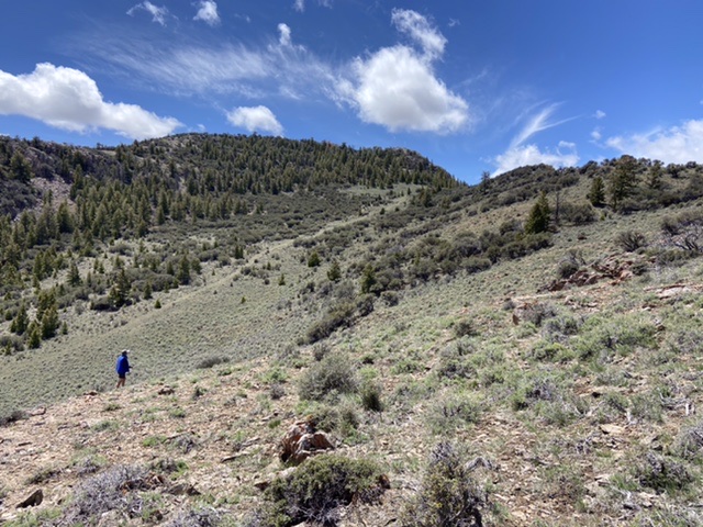
This route follows the east side of the north ridge first across sagebrush-covered slopes and then through forested terrain with widely-dispersed trees to the top of the northeast ridge. Follow the ridge southwest to the summit block, which can be easily climbed via numerous lines.
Climbing the peak’s northeast ridge
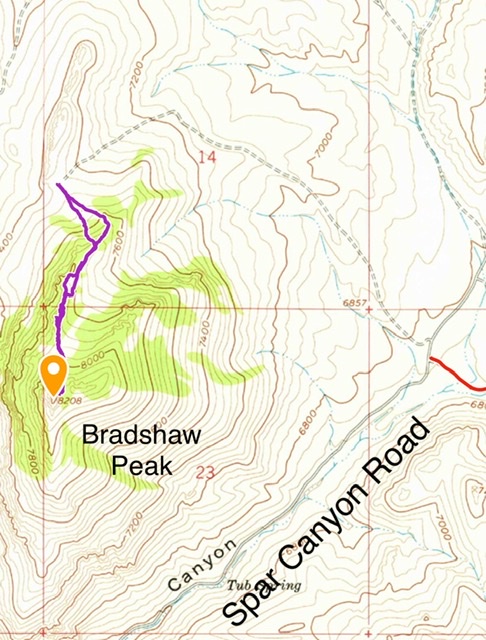
This map shows the 4WD road and the route up the north ridge. This route covers 1.6 miles with 644 feet of elevation gain round trip.
North Ridge and Northeast Ridge/East Face Routes by Livingston Douglas
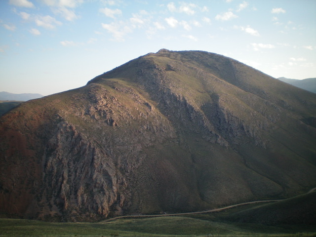
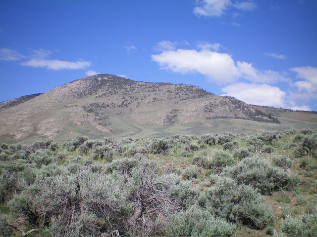
Bradshaw Peak as viewed from the south. Livingston Douglas Photo
Access
Same as for Peak 7891. This is the second leg of a 2-peak adventure that includes Peak 7891 and Bradshaw Peak. It covers 6.5 miles with 2,325 feet of elevation gain.
Map Errors
The USGS topo map and the National Forest Map fail to show an old 2-track road that heads west then northwest to skirt the west side of a narrow, rocky ridge prow. It then descends west to a saddle at the base of the southeast ridge of Peak 7891.
North Ridge, Class 2
The Climb
From the 7,260-foot saddle at the base of the southeast ridge of Peak 7891, follow an old 2-track road (not shown on maps) as it heads east then southeast to a 7,460-foot saddle on the west side of the north ridge of Bradshaw Peak. From the saddle, scramble southeast up easy, open scrub to reach the forested ridge crest of the north ridge. Follow the north ridge to a ridge saddle just below, and left/east of, the rocky summit. The terrain on the north ridge is a mix of scrub, pines, mountain mahogany (lots), and rocky outcrops with only a single 30-foot drop high up. The high saddle separates the true summit from the [lower] east summit. It is a mahogany-clogged mess. From the saddle, scramble southwest a short distance to the summit up an easy, open ridge with some Class 2 face rock without scrub or mountain mahogany. The summit has a modest cairn. It also has a small triangulation post and wiring.
Bradshaw Peak and its north ridge, the skyline left of center. This was my ascent route. Livingston Douglas Photo
Northeast Ridge/East Face, Class 2
The Descent
From the summit, return northeast to the mahogany-clogged saddle between the summit and the [lower] east summit. Bushwhack east through thick mountain mahogany and boulders/outcrops to reach the semi-open east summit. The ridge now bends northeast. Head northeast down the ridge through more tedious mountain mahogany. Stay close to the ridge crest for the easiest going. Emerge from the awful, thick mahogany onto an open saddle (of sorts). From this saddle, there is a clear route down the east face. Head directly at the road junction on Spar Canyon Road where your vehicle awaits. The terrain on the east face is gapped sagebrush with scattered mountain mahogany (initially) then pure sagebrush leading down to the road junction.
The northeast ridge and east face of Bradshaw Peak. This was my descent route. Livingston Douglas Photo
Additional Resources
Regions: Boulder Mountains->EASTERN IDAHO
Mountain Range: Boulder Mountains
Year Climbed: 2022
Longitude: -114.19129 Latitude: 44.27149