Elevation: 8,585 ft
Prominence: 485
This peak is not in the book. Published November 2023
Peak 8585 is a rugged peak that sits at the head of Sheep Canyon in the White Knob Mountains. It can be reached from Sheep Canyon Road but requires a rugged Class 3-4 climb to the summit. The easiest ascent route is from Marsh Canyon Road to the south and goes at Class 2 via the south face. See Rick Baugher’s trip report, linked below, for this route. USGS Big Blind Canyon
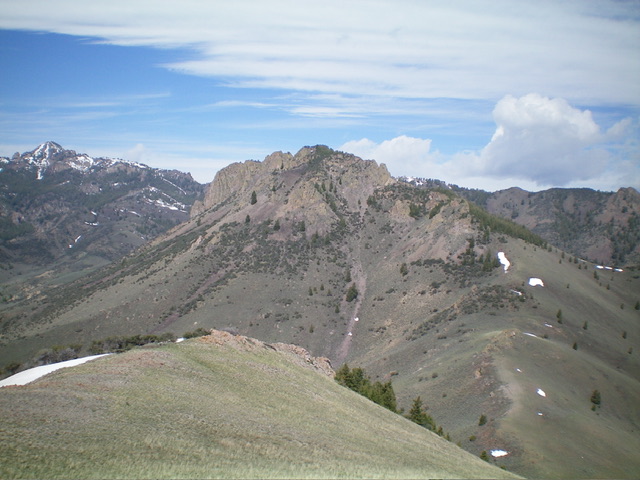
Peak 8585 as viewed from Peak 8290 to its east. Livingston Douglas Photo
Access
From US-93 at Darlington (13.2 miles north of the US-93/US-20 junction in Arco and 2.4 miles north of the Antelope Creek Road junction), drive west on 3700N (a good county road that is unsigned at US-93) for 3.2 miles to a sharp right/north bend in the road. Continue 1.5 miles north on the well-graded county road to an unsigned junction with Sheep Canyon Road. Park at this junction (5,865 feet; 43⁰49’56”N, 113⁰29’17”W).
If your 4WD vehicle has good tires, you can drive a mile up Sheep Canyon Road to an unsigned junction. If you have a 4WD high-clearance vehicle, you can drive about two miles up Sheep Canyon Road to another unsigned junction and cut down on the hiking mileage required for this climb. This adventure includes Peak 8585 and nearby Peak 8290. It covers 10.5 miles with 3,650 feet of elevation gain round trip.
Map Errors
3700N is shown as “Dove Road” on the USGS topo map and is labeled as a 4WD road when it is actually a well-graded county road and does NOT require 4WD. The USGS map fails to show the ATV trail that continues south all the way to the 7,460-foot connecting saddle between Peak 8585 and Peak 8290. The National Forest map shows the ATV trail ending at this saddle when, in fact, it continues southward down a wide gully and probably goes to Marsh Canyon Road. Both the USGS and NF maps fail to show a critical ATV trail junction at about 6,900 feet where another good ATV trail heads west.
East Ridge, Class 4
The Climb
From the base of Sheep Canyon Road, hike southwest up Sheep Canyon Road as it slowly ascends up a sagebrush slope to reach an unsigned junction (shown on maps) at about a mile. Go straight/southwest here. The road narrows and gets rougher now. It also wiggles a bit. At two miles, reach a critical unsigned junction in a narrow meadow and a junction of two canyons. Go hard left/south here onto an ATV trail and avoid hiking farther up into Sheep Canyon (as the straight ATV trail does).
The ATV trail now climbs more steeply and has several twists and turns to reach a third junction (not shown on maps). The better ATV trail continues west but the correct ATV trail heads left/south. The ridge saddle between Peak 8585 and Peak 8290 is now obvious and the ATV trail goes straight to it via a gully. Follow the ATV trail southward up to the gentle, open, grassy saddle at 7,460 feet.
From the saddle, scramble west up the open ridge and come up over a minor hump. Drop 20 feet to a minor saddle then continue west-northwest as the ridge steepens and thick mountain mahogany and large ridge blocks/outcrops take over. Work around the right/north side of the massive ridge blocks and battle through the dense mountain mahogany (soon joined by ridge pines).
Visibility is now nil. The ridge turns left/southwest and flattens. Work along it in a combination of ridge rock/outcrops and mountain mahogany to reach the base of the largest ridge tower. The situation now becomes very steep and ugly. Climb directly up ledges and minor chutes on the northeast side of this tower (Class 4) then scramble up easier (and less exposed) ridge rock to reach an ugly gap after this tower. Downclimb the tower to a minor notch (Class 3+) to reach a second ridge tower.
Skirt this impossible tower on its left side and find a way up ledges and narrow chutes to regain the ridge crest. Continue up Class 3 ridge blocks southwest then west up flatter terrain (thick with pines and mountain mahogany) to finally reach the summit area. Stay right/north on or just right/north of the ridge crest to reach the small, open summit of Peak 8585. I built a cairn on the high point.
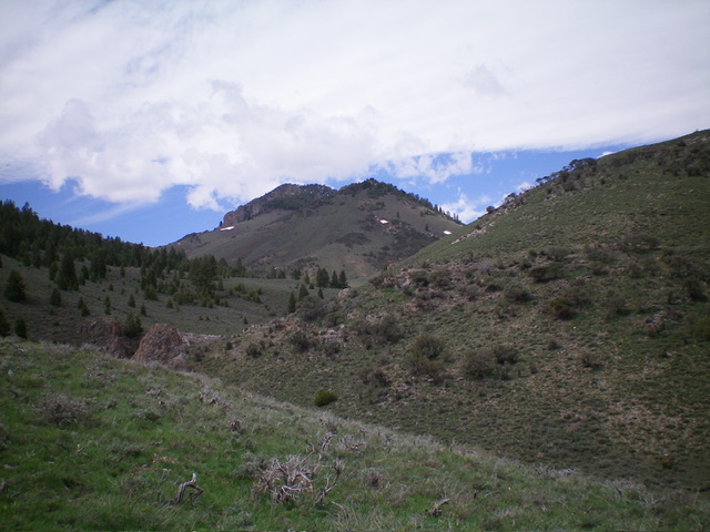
Peak 8585 (dead center) as viewed from the northeast near Sheep Canyon Road. Its ruggedness isn’t visible yet. Livingston Douglas Photo
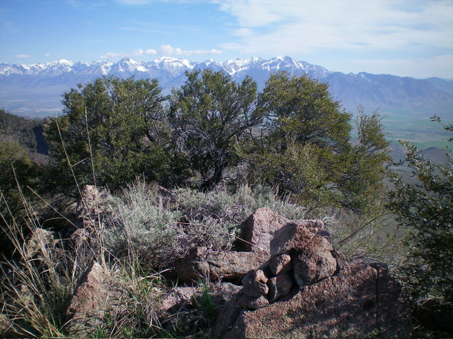
The summit of Peak 8585 with its newly-built summit cairn. Livingston Douglas Photo
East Gully, Class 3
The Descent
From the summit, return east on the thick ridge crest and look for the east gully. It is hard to find but it heads directly east at the connecting saddle with Peak 8290. Descend Class 3 ledges/chutes in fragile rock and mountain mahogany to enter the east gully (which does NOT go all the way to the ridge). Descend the east gully in steep, loose scree/gravel, brush/sage, and mountain mahogany. Grab onto the brush and mountain mahogany to avoid slipping. The underlying loose scree eventually ends and the gully becomes a diagonal contour eastward to reach the lower, easy part of the east ridge just above the connecting saddle. The side-hilling here is not fun due to the very loose gravel/scree that is scattered about. Once on the easy veg of the lower east ridge, cruise down to the saddle. This concludes the first leg of today’s 2-peak journey. Peak 8290 is up next.
Additional Resources
Regions: EASTERN IDAHO->White Knob Mountains
Mountain Range: White Knob Mountains
First Ascent Information:
- Other First Ascent: East Ridge
- Year: 2023
- Season: Summer
- Party: Livingston Douglas
- Other First Ascent: East Gully (Descent)
- Year: 2023
- Season: Summer
- Party: Livingston Douglas
Longitude: -113.5409 Latitude: 43.7929