Elevation: 8,930 ft
Prominence: 310
This peak is not in the book. Published November 2022
Peak 8930 and its sister peak (Peak 9105) are tucked in between Adams Gulch and the Rooks Creek drainage in a seldom-visited part of the Smoky Mountains. They are most easily climbed together from Warm Springs Road to the south. USGS Griffin Butte
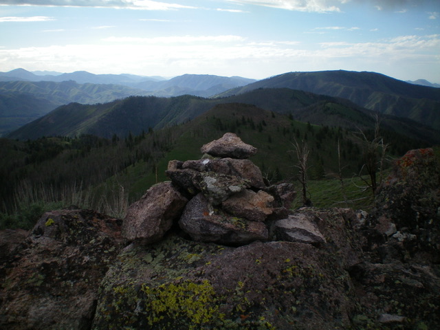
The summit cairn atop Peak 9105 with Peak 8930 just behind it in mid-ground. Livingston Douglas Photo
Access
From ID-75 in Ketchum, turn diagonally left onto [signed] Warm Springs Road. Reset your odometer at this junction. At 2.7 miles, enter the Sawtooth National Forest. At 5.9 miles, reach a signed junction with FSR-049. Drive about 70 yards up FSR-049 and park in a shaded pullout area along the road (6,110 feet). GPS coordinates: 43⁰40’02”N, 114⁰27’10”W.
South Shoulder/Southeast Ridge, Class 2
The Climb
From the junction of FSR-049 and Warm Springs Road, hike about 1.7 miles up FSR-049 (which becomes FST-146) to a sharp right turn at the mouth of a dry gully to the left. FSR-049/FST-146 now leaves West Fork Gulch to climb up and across the south side of Peak 8445 and head over to Eves Gulch. Please note that the Sun Valley Trails Map shows a jeep road heading up this side gully (the USGS topo map shows no such road). There is no jeep road nor any remnants of a jeep road. Leave FSR-049/FST-146 here (6,800 feet) and bushwhack about 50 yards north-northwest up the gully then leave it to scramble right/east to gain the crest of a steep, semi-forested shoulder.
This is a very steep climb in scrub and scattered pines with loose underlying scree/gravel. The shoulder becomes forested higher up. Before reaching the top of the south shoulder, there is a wicked burn area to scramble up through. The brush is thick and the downed timber is everywhere. The terrain is relatively flat as well. It is brutal. Thankfully, it doesn’t last for long. The south shoulder ends at an open saddle on the southeast ridge, just northwest of Peak 8445.
Once on the crest of the southeast ridge, follow it northwest over a few ridge humps in mostly open terrain with one or two forested sections to reach a final ridge saddle at 8,460 feet. Bushwhack west through more scrub to reach the crest of the south ridge. Follow the south ridge right/north to reach the rocky, high summit ridge. This ridge crest is an impressive sight from a distance and can be intimidating. Either climb up over the rocky ridge outcrops (Class 2+/3) or skirt them on their left/west sides (Class 2). The summit high point is a rocky outcrop and has a decent cairn, no doubt built by local hunters.
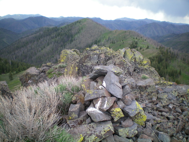
The summit cairn atop Peak 8930. Livingston Douglas Photo
Northwest Ridge, Class 2
The Descent (then Ascent)
From the summit, follow the ridge north (briefly) then northwest through easy vegetation, some scattered blowdown, and loose underlying scree/gravel to reach a mostly-forested saddle. This is the 8,620-foot connecting saddle between Peak 8930 and nearby Peak 9105. This concludes the first leg of today’s 2-peak adventure. Peak 9105 is up next.
South Ridge/West Fork Gulch, Class 2
The Descent
From the summit, descend the rocky south ridge down to easier, wider ridge terrain below. Continue heading north and descend directly into the West Fork Gulch. This gulch is narrow, steep-sided, and relatively thick with vegetation and blowdown. It is not a fun bushwhack. But it is a more direct route back to FSR-049. That’s the only good thing about it. This is 1-1/2 miles of punishment. That said, it took less than an hour to bash through it and reach the blessed jeep road awaiting below (FSR-049). Once on FSR-049, follow it south then southeast back to Warm Springs Road and your parked vehicle. This concludes the final leg of today’s 2-peak journey.
Additional Resources
Regions: Smoky Mountains->WESTERN IDAHO
Mountain Range: Smoky Mountains
Longitude: -114.48129 Latitude: 43.70801