Elevation: 9,233 ft
Prominence: 373
This peak is not in the book. Published November 2020
Peak 9233 is an Idaho peak that may be blocked by private land on the Idaho side (Carmen Creek Road). This is the lengthy route entirely on public land from the Montana side (Ajax Lake). On this route, you must climb the east ridge which is a full-on, Class 3 effort. Remote and rough. That’s how I would characterize this summit. It was a 14.0 mile, 3,250-foot journey for me. Brutal. If possible, try to do this peak via its west ridge from Carmen Creek (Idaho side). USGS Badger Spring Gulch
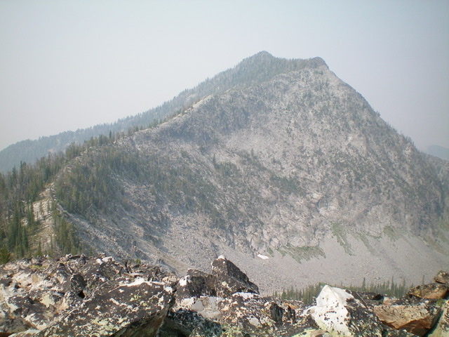
Rugged Peak 9233 as viewed from the saddle at the base of the east ridge. Livingston Douglas Photo
Access
From Wisdom, MT, drive south on MT-278 for 6.6 miles to a [signed] right/west turn for “Twin Lakes Campground.” Reset your odometer here. At 4.1 miles, bear left/south at a signed junction. At 8.1 miles, turn left/south at a signed junction. At 12.9 miles, go straight at a signed junction. At 13.0 miles, reach the NF boundary. The road is now FSR-945. At 16.6 miles, reach a “T” junction. Go right/west on FSR-625/Big Swamp Creek Road. Reset your odometer here.
At 2.3 miles, reach a [signed] road junction with FSR-3944/Slag-a-Melt Road (right). Continue straight on FSR-625/Big Swamp Creek Road. At 4.6 miles, reach a road junction and a road sign that states “Primitive road; Ajax Lake 4 miles.” Park in a large dispersed camping area 0.1 mile past this point (on FSR-625) or continue driving up the road as far as you can. The road is rockier and rougher from here on and gets very rough for the final 0.5 mile to Ajax Lake.
The Approach via Ajax Lake, Class 3
The Climb
From the large dispersed camping area (7,280 feet), hike 4.5 miles up FSR-625/Big Swamp Creek Road to Ajax Lake (8,522 feet). Follow a use trail (sometimes good, other times very weak) around the north side of Ajax Lake to reach the southwest corner of the lake. Look west toward the saddle that separates Ajax Peak from Don Moore Peak. Look for 2 snow-filled couloirs that are just below the saddle. Your goal now is to reach the saddle at the top of these two couloirs. However, going straight west at them is not a good plan as there are cliff bands to block you.
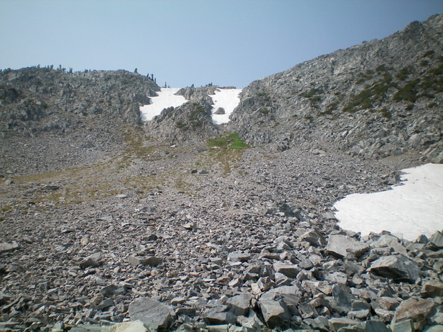
The permanent snow-filled couloirs on the north side of the Ajax Peak/Don Moore Peak saddle. Climb up the arete on the left side of the leftmost couloir (Class 3) to reach the saddle. Livingston Douglas Photo
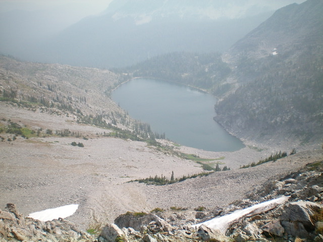
Looking down at Ajax Lake from the Ajax Peak/Don Moore Peak saddle on a smoke-hazy day. Livingston Douglas Photo
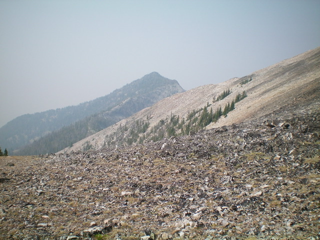
The first look at distant Peak 9233 from the Ajax Peak/Don Moore Peak saddle. The real work now begins. Livingston Douglas Photo
Scramble southwest up boulders to cross to the left/south side of a prominent gully. Climb up through the rock and veg of the ridge/face on the left side of that gully to reach a flatter, angled slope of talus. Head right/northwest to reach an upper talus basin that sits below the two aforementioned couloirs (see photo). Scramble west to the base of the snow-filled couloirs and climb an arete on the left/south side of the leftmost couloir (Class 3). The rock here is generally solid and you will quickly reach the Ajax Peak/Don Moore Peak saddle at 9,460 feet. From here, you can see Peak 9233 to the west. It takes just over 2-1/2 hours to get here and the real work has just begun.
From the saddle, descend southwest down the center of a wide gully of loose talus/scree to reach a basin/meadow at 8,850 feet. From the flat meadow, descend another 50 vertical feet and contour west across boulders to find a good use trail that heads diagonally upward and right/west across a face. This use trail morphs into a game trail and ends just before reaching the Ajax Peak/ Peak 9233 saddle. You will gain 80 vertical feet in this traverse from below the meadow to here. Scramble west across this narrow, clogged, rock/trees/brush saddle. It’s awful. Once across the saddle, you reach the base of the east ridge.
East Ridge, Class 3
The Climb
Climb northwest up the narrow, knife-edged ridge to the [false] east summit (Point 9160+). This climb includes endless ridge towers with krummholz, blowdown, ups and downs, and no escape. Use the left/south side of the ridge to make headway when the towers are impossible to climb over.
The east summit is a magnificent, open, dark-brown, rocky corner point. But your work is not yet over. The true/west summit is still 0.2 miles away and is quite visible from here. Unfortunately, the connecting ridge is another Class 3 mess. More of the same nightmare as the climb up to the east summit, but not as many ups-and-downs. High up, you must do a full-on Class 3 climb up rock to reach the final Class 2 scramble to the summit. There is a decent cairn on the summit.
![The true/west summit of Peak 9233 as viewed from the [lower] east summit. The mix of rock and trees on this traverse is brutal. Livingston Douglas](https://www.idahoaclimbingguide.com/wp-content/uploads/F79981F7-FBE5-4F76-8B61-5BFF741E47F5.jpeg)
The true/west summit of Peak 9233 as viewed from the [lower] east summit. The mix of rock and trees on this traverse is brutal. Livingston Douglas
Alternate Return Route to the Ajax Peak/Don Moore Peak Saddle, Class 2
For an easier navigational (and less uphill) return to the Ajax Peak/Don Moore Peak saddle, try this. Descend the east ridge back to the Ajax Peak/Peak 9233 saddle. Once across the saddle, continue northeast up the southwest ridge of Ajax Peak on solid boulder scrambling. Once you reach about 100 vertical feet below the Ajax Peak/Don Moore Peak saddle, begin a diagonal upward right/east traverse across the south face of Ajax Peak to reach the obvious saddle, which is in clear view from the southwest ridge of Ajax Peak. This diagonal traverse is mostly on solid boulders with a few short sections of loose scree to cross on the way. From the Ajax Peak/Don Moore Peak saddle, retrace the ascent route back to Ajax Lake and follow the jeep road back down to your parked vehicle.
![The summit of Peak 9233, looking east at the [lower] east summit (hump in mid-ground) with Ajax Peak in the distance on a smoke-hazy August day. Livingston Douglas Photo](https://www.idahoaclimbingguide.com/wp-content/uploads/231E4107-D921-4D7B-BFA2-C9E7A401D192.jpeg)
The summit of Peak 9233, looking east at the [lower] east summit (hump in mid-ground) with Ajax Peak in the distance on a smoke-hazy day. Livingston Douglas Photo
![Looking back at the [lower] east summit (hump in mid-ground) and the rugged connecting ridge. The east ridge continues diagonally rightward and down from the east summit in the photo. It is a challenging, time-consuming Class 3 endeavor. Livingston Douglas Photo](https://www.idahoaclimbingguide.com/wp-content/uploads/E75F9DF8-B766-48C3-B27E-13860D69A081.jpeg)
Looking back at the [lower] east summit (hump in mid-ground) and the rugged connecting ridge. The east ridge continues diagonally rightward and down from the east summit in the photo. It is a challenging, time-consuming Class 3 endeavor. Livingston Douglas Photo
Additional Resources
Regions: Beaverhead Range->EASTERN IDAHO
Mountain Range: Beaverhead Range
First Ascent Information:
- Other First Ascent: East Ridge
- Year: 2020
- Season: Summer
- Party: Livingston Douglas
Longitude: -113.75819 Latitude: 45.32439