Elevation: 9,335 ft
Prominence: 355
This peak is not in the book. Published November 2022
Peak 9335 is located just west of the main north-south Smoky Mountains Crest in Camas County. It sits at the head of Royal Gorge and the Bluff Creek drainage. Its south face is particularly rocky and rugged. The easiest way to climb Peak 9335 is from the [elusive] Royal Gorge Trail and the rocky east ridge. USGS Baker Peak
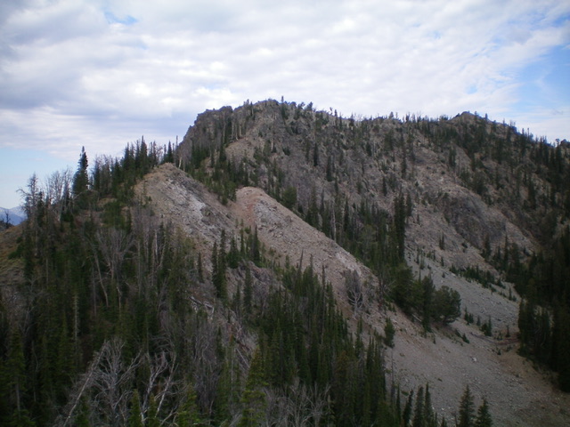
Peak 9335 and its rocky east ridge, my ascent route. The summit is well right of center. Livingston Douglas Photo
Access
The Norton Lakes Trail/FST-135 [(A)(4)(b) on Page 213] is located 1.3 miles up FSR-170 from Baker Creek Road/FSR-162. The trailhead is at 7,645 feet.
East Ridge, Class 3
The Climb
From the Norton Lakes trailhead parking area, follow the Norton Lakes Trail/FST-135 across a footbridge and quickly reach a signed junction with the Norton Creek-Prairie Creek Trail/FST-134. FST-134 is a narrow, overgrown, poorly-maintained footpath, a big contrast to the well-beaten, well-maintained Norton Lakes Trail. Follow FST-134 for 2.3 miles to a signed junction with FST-138 (“Royal Gorge Trail ¾ Mile”). Go left onto FST-138 and follow it for 0.4 miles to a signed junction with FST-835(“Royal Gorge Trail ½ Mile”). This is a spur trail that leads to an unsigned “T” junction with the Royal Gorge Trail/FST-196. Go right onto FST-835. Follow this trail for 0.4 miles to an unsigned junction with a much weaker footpath that goes to the right.
Believe it or not, this is the “T” junction with the Royal Gorge Trail. Go right/northwest here. Do NOT stay on the well-beaten trail that heads south down Bluff Creek (it is the south leg of the lengthy Royal Gorge Trail). The right turn here heads up over a minor saddle then drops into Royal Gorge. It is the north leg of the Royal Gorge Trail. Follow the narrow footpath for 0.1 miles to the crossing of a forested, narrow ridge saddle which is more of a ridge notch. This 8,980-foot saddle sits at the base of the east ridge of Peak 9335. This elusive, hidden saddle is your ticket to the summit of Peak 9335.
Leave the trail and bushwhack west up the [initially easy] forest-and-scrub ridge to reach rockier ridge terrain above. Scramble up through a major ridge tower/block by squeezing through a notch on its left/south side. Don’t try to sidehill around it. Continue west up through rocky, but reasonable, ridge outcrops to reach easier ridge terrain and the small, rocky summit perch of Peak 9335. The summit had a minimal cairn so I rebuilt it and enlarged it. Return to the 8,980-foot connecting saddle with nearby Peak 9615. This concludes the first leg of today’s 3-peak adventure. Peak 9615 is up next.
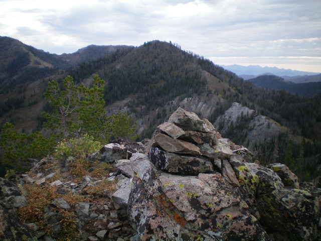
The summit cairn atop Peak 9335 with Peak 9615 behind it in mid-ground. Livingston Douglas Photo
Additional Resources
Regions: Smoky Mountains->WESTERN IDAHO
Mountain Range: Smoky Mountains
Longitude: -114.69329 Latitude: 43.71979