Elevation: 9,367 ft
Prominence: 867
Climbing and access information for this peak is on Page 202 of the book. From personal experience I can state that the route in the book does not work as a Class 3 climb as it encounters impossible towers of rotten rock. Livingston Douglas has provided the definitive update for this peak which includes a detailed update of the East Face/South Ridge route listed in the book and rates the route Class 4 and the Southeast Chute/East Face route which he descended as well as information about the Ross Fork Fire’s impact on the peak. Derek Percoski provided a photo showing his ascent line up the Southeast Chute/East Face route. Updated November 2022
This is truly an interesting peak with many potential steep lines to the summit. Based on my attempt to follow the route in the book, I can state that the route, if it goes at all, would require losing significant elevation to avoid intervening towers and cliffs. USGS Frenchman Creek
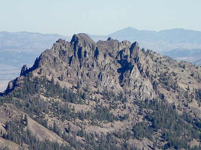
Rugged Peak 9367 as viewed from the southeast. The southeast gully (my descent route) is in dead center. Livingston Douglas Photo
Livingston Douglas Updates and Routes
Access
From ID-75 south of Stanley, turn left/south onto [poorly-signed] Frenchman Creek Road/FSR-195. Drive 2.9 miles to a nice forested pullout on the left/east side of the road just after the road enters the forest after a lengthy stretch in the open valley floor. Park here (7,580 feet). GPS coordinates: 43⁰50’51”N, 114⁰47’23”W.
Book Updates
The book states “hike up to the peak’s south ridge at 8,600 feet.” Well, it’s a challenging scramble in itself to get to the south ridge. I would not characterize it as a “hike.” Granted, I did the approach hike from Frenchman Creek, not Smiley Creek, but the contour lines are similar (or steeper) from the Smiley Creek side of the mountain and it looks rugged when viewed from Smiley Creek. You won’t find game trails or a climber’s trail to help you.
And then there’s Smiley Creek. The book states to “cross Smiley Creek.” Well, that’s easier said than done. The Smiley Creek drainage is wide and is thick with willows, marshes, and beaver ponds. And it’s not a small creek. Bushwhacking across the valley floor from Smiley Creek Road and fording Smiley Creek won’t be easy. The south ridge is rated a Class 3 but I climbed it and it goes at Class 4, not Class 3.
To make matters worse, the Ross Fork Fire swept through the Smiley Creek drainage in early September 2022 and then was blown by west winds up the west face of Peak 9367 and scorched it completely. It was one of the worst burn areas of the 2022 fire season in Idaho. Climbing up through that burn area from Smiley Creek could be very problematic. Stick to the Frenchman Creek side of Peak 9367 which is likely to be much less charred.
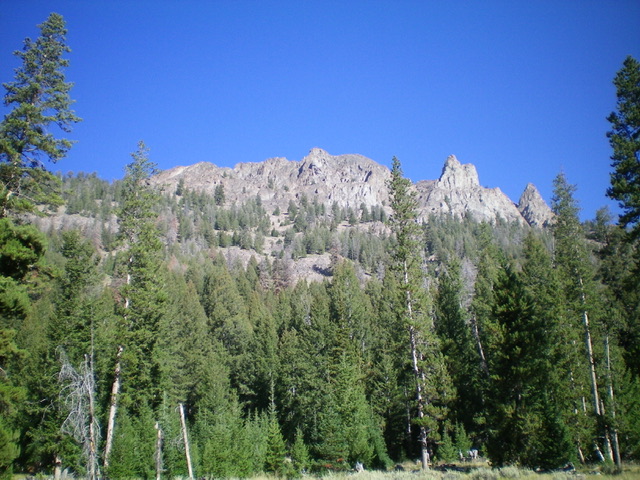
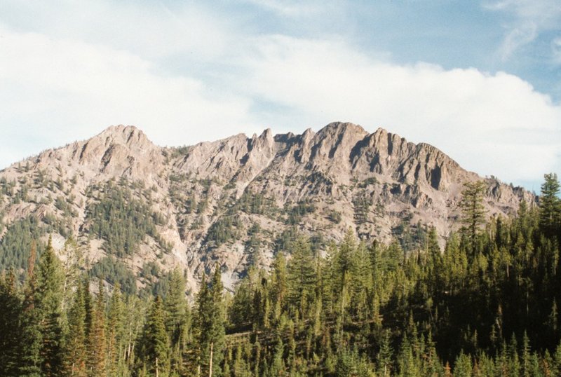
Peak 9367 as viewed from Frenchman Creek Road to its southeast. Livingston Douglas Photo
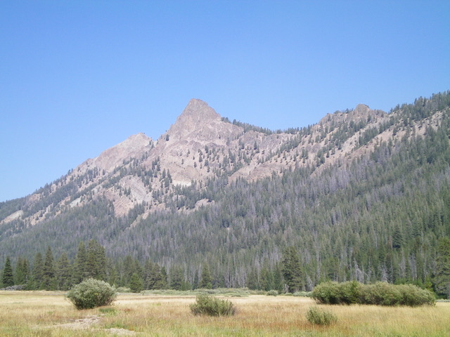
Peak 9367 as viewed from the Smiley Creek Valley to its southwest. Livingston Douglas Photo
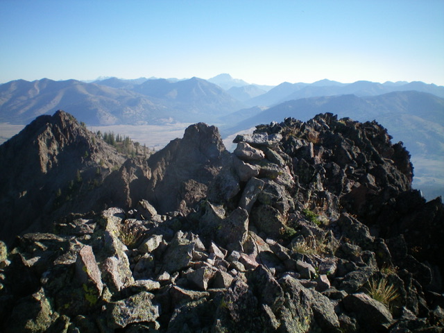
The summit cairn atop Peak 9367, looking north along the rugged summit ridge. Livingston Douglas Photo
East Face/South Ridge, Class 4
The Climb
From the parking pullout, walk north on Frenchman Creek Road briefly into the open valley then bushwhack west-northwest up through a STEEP, fairly thick forest with loose scree/gravel. There are also some Class 3 cliff bands and boulders to navigate. High up, angle right/north to move into a forested gully. Climb up the gully for a short distance to reach the semi-open, forested south ridge at a saddle (8,620 feet). From the saddle, follow the somewhat-steep but easy ridge up to the base of the steep, open ridge blocks/towers and ridge rock about 300 vertical feet above the aforementioned saddle.
Climb up Class 3 ridge rock to reach a large tower that is impossible to climb. Descend right/east down steep ledges and loose, steep scree to skirt the base of the tower, dropping 80 vertical feet in so doing. After passing the tower, climb a steep chute of talus/scree and face rock then exit the chute (to its right) and climb a rib to regain the ridge crest. Follow the knife-edged ridge crest (Class 4) over a couple of minor outcrops/towers to reach another large, impossible ridge tower. Drop 30 vertical feet to the right off the ridge crest to reach a final chute. Climb this chute then exit the chute onto a rocky rib. Cross to the north side of the rib and then scramble diagonally leftward to reach the summit ridge (Class 2). Once on the ridge crest, it is a short, easy scramble to the [surprisingly gentle] rocky high point. The summit had a modest cairn so I built it up.
Southeast Chute/East Face, Class 3
The Descent
Not particularly enjoying the rugged south ridge, I decided to try a different route to descend off Peak 9367 back to Frenchman Creek Road. From the summit, return to the final chute and descend it to find another chute heading right/south. Descend this steep-ish talus chute to reach a bend and two impossible chutes below. Cross talus/scree to the right/south to reach a rib then cross it and descend an easier chute and ledges (the southeast chute), always angling right/south for easier terrain. Once at the bottom of the final chute, descend steep talus/scree into the forest. Downclimb a minor cliff band at 8,400 feet then a more challenging one at 8,200 feet.
Continue steeply down through the forest, angling right-ish/south to reach the road closer to the forested pullout. In some areas of the forest, it’s just easier to descend directly southeast down the face. Reach Frenchman Creek Road less than ¼ mile north of the forested pullout. Peak 9367 is a mess of towers, chutes/gullies, steep face rock/blocks, narrow ribs, exposed knife-edges, and very loose talus/scree on steep angles as well as unreliable, narrow ledges on the face rock and ribs. Take this peak seriously for whichever route you choose to climb.
Derek Percoski Southeast Chute/East Face Route Photo and Commentary
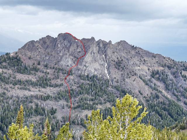
The Southeast Gully/East Face route. Derek Percoski Photo
As shown in the photo, you will want to say out of the gully until
you get past the treeline as the lower section is rugged and broken.
At around 9200′ you’ll see a shortcut gully that branches off to the left
toward the summit. It doesn’t make much difference if you take that or keep
heading straight up.
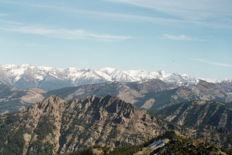
Peak 9367 as viewed from Vienna Benchmark
Peak 9367.
Additional Resources
Mountain Range: Sawtooth Range
Longitude: -114.7926 Latitude: 43.8570