Elevation: 9,380 ft
Prominence: 680
This peak is not in the book. Updated October 2025
Peak 9380 is a rocky summit located in the western section of the White Knob Mountains. It is most easily climbed via its south ridge from the mouth of Stag Creek. Fording the East Fork Big Lost River may be your greatest challenge. There is private land on its north side that make access from the north difficult, if not impossible. USGS Harry Canyon
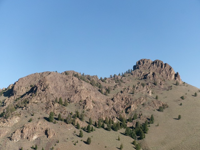
Peak 9380 as viewed from the southeast. The summit block is right of center. I climbed the obvious, steep chute in the center of the summit block. Livingston Douglas Photo
Access
From the signed junction of FSR-135/Copper Basin Road and FSR-136/Wildhorse Creek Road, drive east on FSR-135 for 4.8 miles to a sign for “Stag Creek” and a side road that leads down to a campsite and parking area on the south side of the East Fork of the Big Lost River. This side road is not shown on the USGS topo map and the Challis National Forest map but it is shown on the Sun Valley Idaho Trail Map (Adventure Maps).
Drive down this short 2-track road (4WD recommended) and park in a grassy area/campsite alongside the river. Stag Creek is on the opposite side of the river. This campsite is at 7,160 feet and 43°53’59.7”N, 114°00’16.7”W. This is the first leg of a 3-peak adventure that includes Peak 9380, Peak 9292, and Peak 9268. It covers 9.5 miles with 3,750 feet of elevation gain round trip.
South Ridge/South Chute, Class 3
The Climb
From the grassy parking area/campsite, put on sandals and drop five feet to ford the East Fork Big Lost River. Contrary to another climber’s comments, this fording is not difficult if done in late Summer or Fall. I forded it in early August and the river was not even knee-deep. And the river is hardly 50-feet wide as that climber reports. It is only 20-25 feet wide. You need not wait until the cold mornings of mid-October to do this crossing.
Once across the river, stow your sandals and put on your boots. Follow cattle trails north through the creekside willows to quickly reach sagebrush terrain. Scramble northwest diagonally up a sagebrush slope on a cattle trail to reach the mouth of a dry gully. Bushwhack northwest up a sagebrush shoulder, passing the gully on the way. This shoulder leads directly up onto the crest of the south ridge of Peak 9380. Follow this magnificent open ridge northward in easy, short scrub all the way up over Point 8672.
From Point 8672, descend 45 feet northeast to a minor saddle. Continue north then northwest up the rounded ridge. Leave the ridge and contour northwest under Point 8990 to reach Saddle #1 at 8,820 feet. Stay in the reasonable sagebrush and below rocky sections higher up in completing this traverse. From sagebrush-covered Saddle #1, bushwhack west up steeper sagebrush to reach the base of the summit cliffs. Scramble west up a gully on the left/south side of the summit cliffs to reach the base of the south chute (this chute is visible as you climb the south ridge).
The south chute cuts the south face of Peak 9380 in half. Scramble right/north up this narrow, rocky chute. Climb face rock with good holds on the right/eat side of the chute (Class 3). Move back into the chute higher up and quickly reach its top and a ridge (of sorts). This ridge heads left/west to the summit. Scramble up the Class 2 ridge/face rock to the summit. The summit has a large cairn.
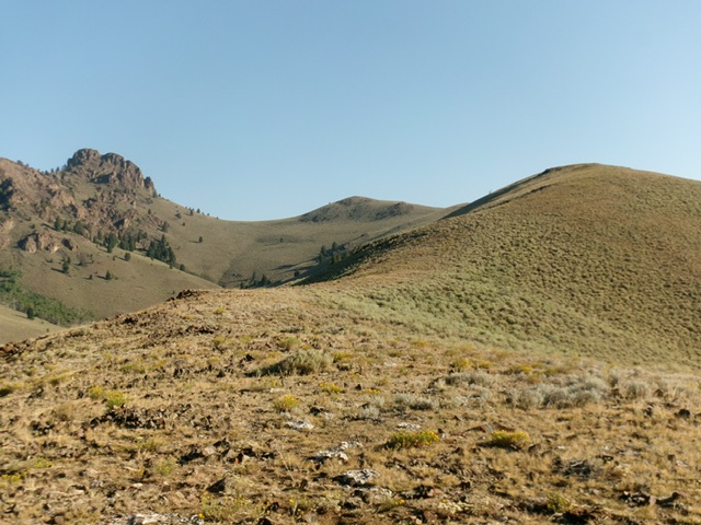
Peak 9380 (rocky outcrop left of center) as viewed from midway up the easy, sage-covered south ridge. This was the first leg of my ascent route. Livingston Douglas Photo
Northwest Gully/West Face, Class 2+
The Descent
From the summit, return to the top of the south chute. From here, descend the easier, wider northwest gully (the Baugher route). This gully is mostly loose talus and scree and requires some care in descending. Reach the pine forest below and reach flatter, easier, non-rocky terrain. Head left/southwest underneath the many ridge towers and aretes on the west face of Peak 9380. Bushwhack southwest then west through easy pine forest (albeit on an angled slope) to reach the hidden saddle with Peak 9292. This 8,780-foot connecting saddle concludes the first leg of today’s 3-peak journey. Peak 9292 is up next.
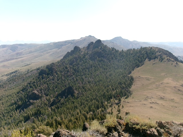
Peak 9380 and its forested west face as viewed from Peak 9292. The connecting saddle is right of center. This photo shows my descent route from Peak 9380. Livingston Douglas Photo
Additional Resources
Regions: EASTERN IDAHO->White Knob Mountains
Mountain Range: White Knob Mountains
Longitude: -114.01689 Latitude: 43.93329