Elevation: 9,524 ft
Prominence: 384
This peak is not in the book. The name was suggested by Rick Baugher. I added two photos by Rick Baugher to the bottom of this page. Published November 2021
Peak 9524 is a rugged, rocky summit that is located at the head of Crows Nest Canyon on the west side of Pass Creek Road in the Lost River Range. USGS Methodist Creek
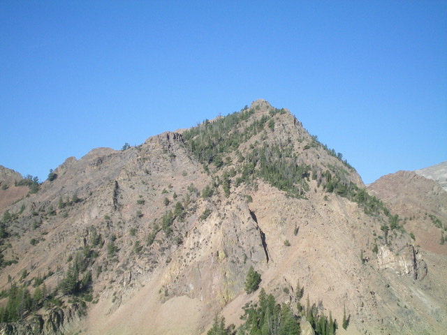
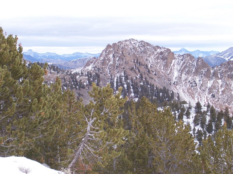
Peak 9524 (right of center) as viewed from the northeast. Livingston Douglas Photo
Access
This is the first leg of a 2-peak adventure that includes Peak 9524 and Peak 9386. It covers 10.0 miles with 4,300 feet of elevation gain round trip.
Pass Creek Road/CR-122 is located along US-93 south of Mackay and is signed as 3900W. This junction is exactly 7.4 miles south of Main Street in Mackay and 18.3 miles north of the junction of US-93 and US-20 in Arco. Turn north onto [signed] Pass Creek Road and drive 4.4 miles. Park in a large pullout on the left/west side of the road at the base of an old 2-track road (6,100 feet). Just across Pass Creek Road (on its east side) is the [signed] Pass Creek Ranch.
The Approach, Class 2
From the parking pullout, hike west for about ½ mile to a fence row and a patch of private property. If you lack landowner permission, follow the fence row right/north up to the National Forest boundary then head west along that boundary into Crows Nest Canyon. If you have landowner permission, cross to the south side of the drainage and find the continuation of the 2-track road heading west up a shoulder. Follow the 2-track road as it crosses a second drainage (with a small creek) and climbs up onto another shoulder just west of the first shoulder (see USGS topo map).
Continue up the 2-track as it bends right-ish/northwest into Crows Nest Canyon. The 2-track eventually ends and a use/game trail continues well up into the canyon in its center or just right of center. The terrain in the canyon is mostly sagebrush then becomes mostly pine forest with a few scant open areas of sagebrush. Visibility is limited and there are multiple side gullies and shoulders that confuse the issue. You will be able to always see the massive cliffs on the right/east side of the canyon to stay on course. High up in the canyon, the game trail disappears after passing a massive boulder/talus field on the right/east side of the canyon at the edge of the pine forest.
Scramble north up a talus gully (at the base of the east side cliffs) to reach the west ridge at about 9,400 feet, quite close to the summit. I would call this the South Gully/West Ridge Route. Unfortunately, that is not how I reached the west ridge. Once past the massive boulder/talus field, continue heading up the center of Crows Nest Canyon through forested terrain and a mix of side gullies and shoulders. When the canyon bends left/west, continue straight/north to intercept the west ridge at about 9,050 feet. The final push to the ridge crest requires a steep face climb up steep, loose gravel/scrub. A diagonal game trail will help you in this section.
West Ridge, Class 3
The Climb
Once on the west ridge (at about 9,050 feet), follow the ridge crest right/northeast and skirt just below a massive ridge buttress (Point 9200+) and drop 40-50 vertical feet to reach a ridge saddle that sits just above a rock-filled depression to its north (shown on the USGS topo map). From the saddle, follow the ridge crest east-northeast, skirting the right/south side of ridge towers as necessary.
The ridge terrain is almost immediately pretty rough. The ridge crest itself is impossible due to numerous ridge towers. Stay below the towers and find a notch in an arete. This notch has a clump of pine trees on its east side. Once through the notch, cross a few crumbly chutes and ledges on the right/south side of the ridge to reach the summit block. Climb back up onto the ridge to finish off the peak with an easy Class 2 scramble on ridge rock to the top. The summit has a decent cairn.
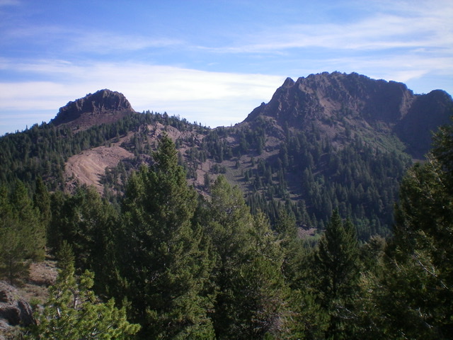
Peak 9524 (summit is right of center) as viewed from the southwest. The west ridge is the skyline from the rocky buttress (left) to the summit (right). Livingston Douglas Photo
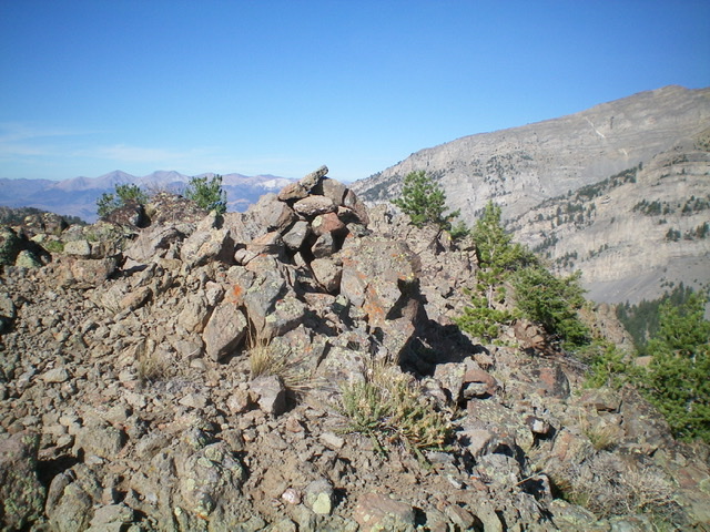
The large summit cairn atop Peak 9524. Livingston Douglas Photo
The Descent
Return back down the west ridge to the ridge entry point described earlier. Continue southwest down the semi-open forest of the ridge crest on loose scree/gravel to reach the small, hidden connecting saddle with Peak 9386. This saddle is at 8,900 feet and concludes the first leg of today’s 2-peak journey. Peak 9386 is up next.
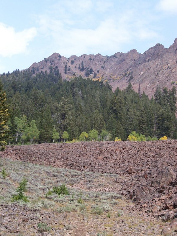
CROWS NEST PEAK From the andesite boulder field at 8800′ the view is north up Crows Nest Canyon. The 9524′ summit is positioned behind the middle tower. The easiest route follows the gully to the right of the left tower, then follows the ridge east (right). Other interesting lines await exploration. Rick Baugher Photo.
View NW to Crows Nest Peak el 9524′ (prominence 384′) which is actually a southeast spur of Invisible Mountain. Framed on the horizon is the Lemhi Range. Bell Mountain on left, and Diamond Peak right. 11/20/06. Rick Baugher Photo.
Additional Resources
Regions: EASTERN IDAHO->Lost River Range
Mountain Range: Lost River Range
Longitude: -113.48201 Latitude: 43.95719