Elevation: 9,532 ft
Prominence: 832
This peak is not in the book. Published November 2022
Big Witch Peak is a sprawling mass of high ridges that offer great scrambling opportunities, particularly from the north and from the southwest. The peak is most easily reached from the Timber Draw Trail/FST-166 to its north. USGS Hyndman Peak
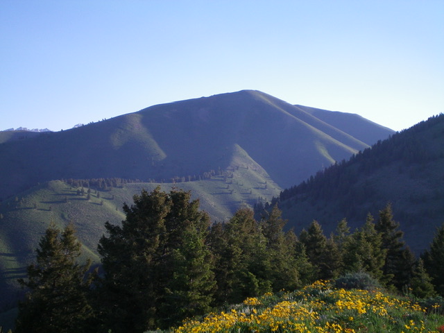
Big Witch Peak as viewed from the north. The summit is left of center. Livingston Douglas Photo
Access
From ID-75 north of Hailey, drive east then northeast up [signed] East Fork Road for 11.0 miles to the Federal Gulch Campground (right). Drive 0.2 miles through the campground to reach the turnaround at the trailhead for Federal Gulch Trail/FST-169. Park at the trailhead (6,850 feet). The USGS topo map fails to show the Timber Gulch Trail/FST-166, a critical oversight.
Timber Draw/Northeast Ridge, Class 2
The Climb
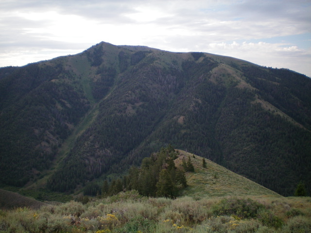
The summit area of Big Witch Peak. Livingston Douglas Photo
From the Federal Gulch trailhead, hike about ½ mile up Federal Gulch Trail to a signed junction with the Timber Draw Trail/FST-166. Go right/south up FST-166 and follow it for about 2.4 miles as it makes its way up Timber Draw then does a series of forested switchbacks to reach a high saddle at the base of the northeast ridge. Leave the trail here and follow a horse trail (on-and-off) southward up the sagebrush-covered ridge to reach the summit ridge at about 9,500 feet. Go right/west here and reach a cairned point at a ridge corner. This is not the summit. Head left/south and drop 30 feet to a minor saddle. Continue south up a rocky ridgeline to reach the high point of Big Witch Peak. The summit has a modest cairn. The far south end of the summit ridge is 10-15 feet lower (as per my altimeter), though the USGS map implies that it is higher.
North Ridge/North Face, Class 2
The Descent
From the summit, return north-northeast to the cairned ridge corner point. From that point, follow the nice, open ridge crest left/northwest to a sagebrush saddle. This section of the ridge is a combination of scrub, loose shale, and minor ridge outcrops. From the saddle, scramble northwest up 130 vertical feet to the top of Point 9283. Head right-ish/north from Point 9283 down a steep section of rocky outcrops and loose scree to reach flatter ground and easier going. Once down to 8,800 feet, look for a ridge heading northwest. I couldn’t find it in the thick forested terrain. If you find it, follow it down to the Federal Gulch Trail and hike back to the trailhead.
From the 8,800-foot level, descend north on a ridge to 8,600 feet. From there, the ridge is gone so veer left-ish/northwest on a shoulder of sorts which soon turns into a face with lots of veg and blowdown in the forested terrain. Farther down, move left/west across a gully to reach a shoulder. The bushwhack across the dry gully is wicked. Once on the shoulder, follow it northwest then north down to the Federal Gulch Campground. The north side of Big Witch Peak is thickly forested and offers no visibility, so it is very difficult to stay on route. The forest bushwhack is difficult, a complete contrast to the magnificent, open ridgelines high up.
Southwest Ridge, Class 2
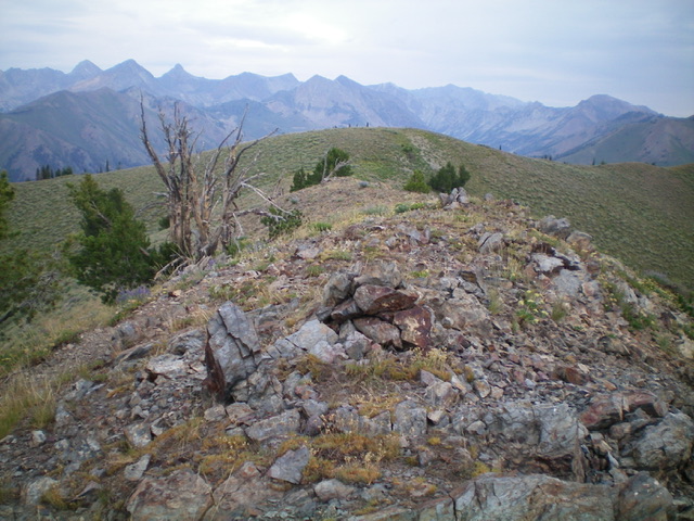
I got a good look at the magnificent, open southwest ridge of Big Witch Peak from Peak 8005 (see photo), which sits above Big Witch Creek near the Cove Creek drainage. Follow an excellent cattle/use trail up the left/northwest side of Big Witch Creek up to the 7,000-foot level and a fork in the Big Witch drainage. The southwest ridge begins here. Leave the drainage and climb northeast up the open southwest ridge all the way to the summit. This is a longer route but is in completely open terrain.
Big Witch Peak as viewed from Peak 8005 to its south-southwest. The southwest ridge comes up from the lower left of the photo then bends straight uphill in the center of the photo. It looks like a magnificent route to climb. The summit is in dead center. Livingston Douglas Photo
Additional Resources
Regions: EASTERN IDAHO->Pioneer Mountains
Mountain Range: Pioneer Mountains
Longitude: -114.14191 Latitude: 43.64309